Thursday, February 26, 2009

Meandering With The Marin County Parks & Open Space Department

If you're looking for yet more outdoor opportunities in Marin, the County Parks & Open Space Department will be offering a number of outings from March through May. Some will mirror hikes we'll be doing, and others will go to places not on our hiking schedule. (Click here to view and print out their Spring 2009 newsletter with a calendar of events). (For all events: Heavy rain cancels some events; dress in layers, wear appropriate clothes, shoes and gear; bring water and snacks; use Google maps to locate meeting points. If you have questions call 415.499.6387 or visit www.marinparks.org)

Following is information on six of of their many planned outings which will be led by the Open Space District's Interpretive Naturalist, David Herlocker (dherlocker@co.marin.ca.us or 415 499-3647):
  • Thursday, March 12, 10am to 2pm, Baltimore Canyon
    So many trails, so many choices: whether we head down to see the waterfall or traverse the chaparral to relax at Echo Rock, we’ll find early wildflowers and spectacular views. Meet at the Crown Road Trailhead (from Sir Francis Drake Boulevard, go south on College Avenue, right on Woodland, left on Evergreen; continue uphill to Ridgecrest; 50 feet uphill from this junction, go left onto Crown Road and follow to end).
  • Friday, March 20, 9am to 3pm, Big Rock—to the Top
    We’ll take our time enjoying the gentle grades of the Big Rock Trail as we ascend the second highest peak in Marin. We’ll look for flowers and other natural highlights as
    we make the 1,200 ft climb and still have plenty of time to enjoy lunch at the top.
    Meet at the Big Rock Trailhead (about 5 miles west of Highway 101 on Lucas Valley Road).
  • Saturday, April 11, 9am to 2pm, San Geronimo Ridge
    The ridge at the top of Gary Giacomini Preserve is one of the great gems in the county. Wildflowers (including some unusual serpentine endemics), a pygmy Sargent Cypress forest and incredible views are our reward for the sustained climb that will bring us out of the valley. Meet at the Willis Evans Trailhead (formerly Bates Canyon, on Redwood Canyon Drive, not Redwood Drive).
  • Wednesday, April 29, 9am to 2pm, Wildflowers and Wildlife at Carson Falls
    This walk starts with the unique serpentine flora of the Pine Mountain Fire Road, and
    continues to the spectacular Carson Falls area where flowers, butterflies and frogs
    are abundant. Meet at the Pine Mountain Fire Road Trailhead (about 1 mile south of
    the Meadow Club on Fairfax-Bolinas Road).

  • Sunday, May 17, 9am to 2pm, Birds of Mount Burdell
    By now the breeding season should be in full swing as the Bullock’s orioles, lazuli buntings and black-headed grosbeaks provide both a soundtrack and an elaborate color scheme. Meet at the Marin County Open Space District gate (end of San Andreas Drive, Novato).
  • Wednesday, May 27, 10am to 2pm, Wildflowers of Ring Mountain
    The late season bloom on this ridge includes one of the rarest and most unusual plants in the world, the Tiburon Mariposa Lily. We’ll look for this and other flowers as well as butterflies, birds and other wildlife. Later in the day, we may travel to Old Saint Hilary’s Preserve to see the lovely Tiburon Jewelflower. Meet at the end of Westward Drive, Corte Madera.

Deer Park to Phoenix Lake Hike (March 3) Preview

For the first time since mid-December, we'll be back hiking in the Mount Tam watershed lands managed by the Marin Municipal Water District. Here's Wendy's description of this hike: "We're so lucky to have such beautiful areas so close to central Marin! We should see baby blue eyes, Indian paintbrush and other wildflowers, and early butterflies like the spring azure!". (We did this hike much later in the Spring last year on April 29th - click here for a recap of that outing --- so we may not see the same plants that we spotted that time).

Directions to trailhead: Go west on Sir Francis Drake Boulevard to Fairfax. As you enter Fairfax, turn left at the gas station, and make an immediate right in front of the movie theater. This puts you on Broadway. Make the first left onto Bolinas Avenue. Just after it veers left, turn left on Porteous Avenue. Follow it to the parking lot at Deer Park. 15 minutes from College of Marin. Restrooms at trailhead. (Click here for a Google Map showing the area near the trailhead and for driving directions).

Weather forecast: As of Thursday, February 26, the National Weather Service forecast for Fairfax on Tuesday, March 3rd, was mostly cloudy with a chance of showers and a high near 54. (Click here for an updated forecast).

More on this hike: Presumably we'll follow the same route as last year. The Martin's Hiking in Marin trail guide does not have a single map and directions for our hike from Deer Park School to Phoenix Lake and back, but you can use the following two maps and hikes from their book to piece together our path:

Start off using the Martin's Hike "C6 - Deer Park Road - Yolanda Trail". Head up the Deer Park Fire Road to Oak Tree Junction, then turn left (to the south) and hike uphill on the Six Points Trail. When you reach the Six Points junction, switch to Hike "C4 - Hidden Meadow - Yolanda Trail" and hike down the Yolanda South Trail to Phoenix Lake.

Using that same hike and map, follow Shaver Grade uphill, and while doing so, refer back to the C6 hike and map to follow the Grade to Five Corners. Continue straight down Deer Park Fire Road to Boy Scout Junction. Cross the fire road and take the Junction Trail back to its intersection with Deer Park Fire Road (just where you turned off onto Six Points Trail when you were headed toward the lake).

MMWD has a printable map of its watershed which shows these trails, and here's a Google Earth view looking from Deer Park over Bald Hill towards Phoenix Lake. We'll head from bottom to top and a little left of center in this picture to reach the lake, then turn right at the lake and go from top to bottom by starting up Fish Gulch (shown in purple lettering on the photo) and onto the Shaver Grade (shown in white lettering). Click on the photo to open a larger image in your Web browser.

Tuesday, February 24, 2009

Back At The (Audubon Canyon) Ranch - February 24th

For the first time in days, sunshine greeted us as we fell out of bed, ate breakfast, packed up our gear, and drove west to Bolinas Lagoon to hike the trails surrounding Audubon Canyon Ranch. Unlike our trek up Steep Ravine a week ago, the only clouds on the horizon were light and puffy white posing no chance of raining on our parade over hill and dale. Within a half hour of starting our hike (almost precisely on the stroke of 10 am), the slight chill we'd felt during our pre-hike roundtable discussion had dissipated and we began to strip off layers of clothing as we headed up the Zumie's Loop Trail towards Bolinas Ridge.

During recent hikes we had spotted a lone Douglas Iris here and there. This week we started seeing them in groups. Turkey Vultures enjoyed the warming air as well, soaring above us as we climbed the steady, steep trail across the open chaparral land above Bolinas Lagoon. Allen's Hummingbirds that had spent the winter in Mexico joined the "TV's" in the sky overhead, heralding the arrival of the spring mating season. (Click here for Wendy's list of all flora and fauna spotted on this hike).

About an hour and a half into the hike we left the open hillsides and entered a forest of redwoods nourished by winter rains and drippy, summer fog. Here and there we found the remnants of the waning mushroom season. Now our ever upward trek turned into a down, then up, then down, then up again descent and ascent as we crossed the first of two fern and redwood lined streams that divide three ridges into parallel canyons on the Audubon preserve lands.

Two hours after setting out, we left Zumie's Loop and turned left and uphill on the Griffin Loop Trail. Before long, we were dropping down into another small watershed where sunlight filtered through the redwood canopy above onto the ferns below. We weren't the only ones enjoying the cool, fresh air in these leafy defiles --- salamanders and newts "hung out" here, too. Crossing the next stream was an exercise in "walking the plank" --- with "helpers" stationed on either side of the creak to make sure now of us went swimming with the amphibians.

For the next half hour or so we continued a fairly gentle traverse of the hillside until the forest began to give way to chaparral again. At 12:45 pm we plopped down in a clearing where the Griffin and Bourne Trails meet and enjoyed our mid-day meal in the sunshine.

Unlike the earlier part of the trek, it was literally all downhill from here. Along the way we stopped to join Silvia in singing a birthday serenade to Wendy to the tune of "Hi Lili, Hi Lo". (Click here for the lyrics to to the song sung by Leslie Caron in the movie "Lili"). After a half hour of walking, and putting 4-5 miles behind us from the outset, we were back to the preserve headquarters and the end of a fine Spring weather hike.

(This Google Earth satellite photo shows the area we hiked in on Tuesday. Click on the photo to open a larger image in your Web browser)
(Pictures of this hike are now on-line. You can view them in the mini-slideshow window in the "Meandering In Marin On Tuesdays" blog, or by clicking here to go directly to the Picasa Web album of photos from the latest hike).

Friday, February 20, 2009

Sign Up Now For Spring Hiking Series

Our Winter "Final Exam" hike is scheduled for Tuesday, March 17th at Bon Tempe and Lagunitas Lakes. The first Spring hike will be Tuesday, March 24th (at Indian Valley Open Space in Novato) and continue every Tuesday (except for April 14th) through May 12th. (Monday hikes run March 23rd through May 1th with no class on April 13th).

Registration for the Spring 2009 College of Marin "Meandering" hike series will begin this coming Monday, February 23rd. Click here to enroll on-line. To hike on Tuesday, sign up for course #35107 EC. (Monday's class is course #35106 EC). Cost for the series is $115.00. (A complete list of the hikes will be posted on the blog when it becomes available).

Another View of Steep Ravine And Dipsea Trails

Isn't technology fun! In this image, the earth has been titled up so you can get a "3D" view of Mount Tam and a better idea of the terrain in Steep Ravine. The Dipsea Trail is clearly marked where it runs across the top of the ridge, although you can't see where we turned back into the trees to make our descent down the steps and back to the Dipsea's junction with the Steep Ravine Trail. (Click on the photo to see an enlarged picture in your Web Browser).

Bird's Eye View of Our Steep Ravine/Dipsea Trail Hike

This Google Earth satellite photo shows the area we hiked in on Tuesday. The end of "Steep Ravine Canyon" appears on the ocean side of Highway 1. The forested area on the other side of the highway is where the Steep Ravine Trail runs up to Pantoll (which is the open area you'll find along a line between the "Wooded Knoll" and "Cardiac Hill" landmarks). The Dipsea Trail is the squiggly brown line that runs along the ridge top from "Cardiac Hill" towards the ocean. Panoramic Highway is the white squiggly line which can be seen climbing uphill from Stinson Beach into the forested area on its way toward Mill Valley. (Clicking on the photo should give you a larger image in a window in your Web Browser).

Thursday, February 19, 2009

Audubon Canyon Ranch Hike (February 24) Preview

For our next hike, we'll move a few miles north of where we climbed up Steep Ravine and stepped down the Dipsea Trail and visit Audubon Canyon Ranch's Bolinas Lagoon Preserve. The preserve doesn't open to the public for birdwatching until March 14th this year, but as Wendy says, "Lucky us! We have permission to hike in Audubon Canyon Ranch! This is beautiful habitat, not usually open to the public."

Directions to trailhead: Coming from North or Central Marin: Take Sir Francis Drake Boulevard to Olema. Turn south (left) on Highway 1 and follow for about 10 miles to Bolinas Lagoon. Preserve will be on the left approximately 1 mile further. Carpoolers can meet at St. Rita's Church in Fairfax at 8:45 am.

Coming from Southern Marin:
From Highway 101 take the Stinson Beach exit. Follow approximately 12 miles to Stinson Beach. Continue 3 1/2 miles north to the preserve gate on right hand side of the highway.

Time: 1 hour from College of Marin. Restrooms at trailhead.

Weather forecast: As of Thursday, February 19th, the National Weather Service forecast for Bolinas on Tuesday, February 24th, predicted a chance of shower under mostly cloudy skies with a high near 59. (Click here for an updated forecast).

More on this hike: If you have the Martins' book, Hiking Marin, go to hike "F18 Griffin Loop - Bird Overlook Trails" for a map of trails within the preserve. There are two major loop trails (probably about 3 miles long each) going uphill and down, and a shorter 0.8 mile loop nearer to the bottom of the hill.

Wednesday, February 18, 2009

Meandering On Angel Island

So, if hiking with Wendy, Bob Stewart, and the Marin Agricultural Land Trust still doesn't satisfying your need to get out and about in Marin County, hop the ferry from Tiburon to Angel Island State Park and go on one of the hikes (February 28-June 7) run by the Angel Island Association. (Silvia Lange of our Tuesday "Meandering" group will no doubt lead some of these outings; check with her to find out on which dates she'll be working on the island).

Meander in Marin with MALT

Every Spring and Fall, the Marin Agricultural Land Trust (MALT) runs hikes and tours in West Marin on properties covered by conservation easements or engaged in agricultural pursuits. You can taste milk, wine, olive oil and oysters, and meet some of Marin's ranching families.

MALT has just posted its Spring (March-June) list of hikes and tours on its Web site (www.malt.org). To sign up for an event, click the pre-registration link on the event listings, or contact MALT at 415-663-1158 or hikesntours@malt.org. (Members get a discount on hike and tour fees; click here to become a member --- it's under the "Donation" heading on this Web page).

Here are two of the eight outings that might be of particular interest to our hiking group:
  • Leiss & Corda Ranches
    Wildflowers, Vineyards & Wine Tasting

    Saturday, March 20

    Hike over pastures and through the woods with Leiss family members on their ranch in Chileno Valley where wildflowers grow in profusion. Botanist and co-founder Phyllis Faber will help identify the flowers. From there, hike overland to the Corda Vineyard. Those who can't make the scrambling hike can drive to Corda Ranch, and then take a hayride to the vineyard where we'll hear from Mark Pasternak, Marin's most prolific grape grower. Wine tasting at the Corda Winery included. Click here to complete the required pre-registration for this event.

    TIME: 10 A.M.–3 P.M.
    WHERE TO MEET: 179 Wilson Hill Rd. From Marin, go west on Hicks Valley/Wilson Hill Rd. Go right at intersection with Marshall/Petaluma Rd. 2.75 mi. to Leiss Ranch on right. From Petaluma, take Western Ave. west for 2 miles; turn left at Chileno Valley Rd., 4.1 mi. to ranch.
    WHAT TO BRING: Water, picnic, hiking shoes
    DEGREE OF DIFFICULTY: Wildflower walk and hayride tour boot Ranch to Vineyard hike bootboot
    COST: $30 / $35 non-members
  • Ryan-Tocalino, Grossi, Daniels & Dolcini Ranches

    Saturday, May 9

    Join Marin County Open Space Naturalist David Herlocker and Alison Kiehl, MALT’s Stewardship Associate, for a long hike starting at Stafford Lake and wending over four ranches with MALT easements. You’ll see some spectacular views and visit hidden valleys and redwood groves. Learn about the ranching operations as well as the natural habitats and identify a variety of birds, plants, and wildlife. Click here to complete the required pre-registration for this event.

    TIME: 11 A.M.–3 P.M.
    WHERE TO MEET: Stafford Lake County Park, 3 miles west of Novato; Free parking at Area #5
    WHAT TO BRING: Water, picnic, hiking boots that can get dirty and wet
    DEGREE OF DIFFICULTY: bootbootboot
    COST: $25 / $30 non-members

Meandering Here and Afar with Bob Stewart

Before our Muir Woods hike (February 10th), Wendy passed around copies of a brochure on outings in Marin and elsewhere being led by Bob Stewart. Here are the Bay Area day trips he has planned for April:
  • Wednesday, April 1st - Mount Burdell
  • Thursday, April 2nd - Mitchell Canyon, Mount Diablo
  • Tuesday, April 7th - Chimney Rock, Point Reyes National Seashore
  • Wednesday, April 8th - Mount Tam
Stewart will also be running trips in the Southwest and Mexico during the Spring and Fall, and to Trinidad and Tobago and the mountains of California in the Summer. (Click here to view and print a copy of his brochure).

Bob Stewart (like Wendy) has been an instructor for Point Reyes Field Seminars. Here's his "bio" for a 2001 PRFS brochure: "Bob Stewart has taught biology in public schools and College of Marin, and served as Landbird Biologist and Director of Education at the Point Reyes Bird Observatory. For 15 years Bob worked for the County of Marin and is well know for the 2,000 plus outings he led for the general public on a variety of topics including: bird behavior, butterflies, insects, mushrooms, grasses, flowering plants, habitats and general ecology. Since 1973, he has led birding and natural history tours to a variety of locations around California and the Southwest, and Central America. Look for his books Common Butterflies of California, and Butterflies of Arizona, A Photographic Guide."

Stewart now lives in Patagonia, Arizona (southeast of Tucson) and can be reached at: P.O. Box 1274, Patagonia, AZ 85624, tele: (520) 394-0114.

Tuesday, February 17, 2009

Deja Vu All Over Again (Steep Ravine, Feb. 17)

Last year's hike in Steep Ravine on the Tuesday after President's Day was wet. After three days of pretty solid downpour in Marin, this year's outing looked to be a reprise, weather-wise. One of us (Linda) was smart and went to Maui. Others presumably tuned into the TV weather forecast the night before, heard the weather report on the radio Tuesday morning, or read the prediction of rain and thunderstorms in the morning San Francisco Chronicle or Marin I-J, and decided that discretion (i.e., staying home) was the better part of staying dry. But The Magnificent Seven (Wendy, her former student, Matthew, Angela, Nate, Silvia, Stan, and Dick) threw caution to the wind and drove through dwindling rain showers to the trailhead and were rewarded with a fine winter hike along a 
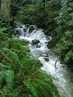
fern-lined trail past cascading waterfalls.

Although the weekend's rain ended before our hike began, copious flows of water out of Muir Woods and down Redwood Creek flooded the entrance to the Muir Beach parking lot, preventing anyone without a high-clearance vehicle from making a pre-hike "pit stop" at that location. (Fortunately, "rest facilities" were available just down the road at the Muir Beach Overlook). The stretch of Highway One from Muir Beach to Stinson Beach has often slumped down toward the ocean during winter rains. But the last road repair job seems to be holding, the pavement is pot-hole free, and although the road winds back and forth across the hillsides, this morning it afforded grand views to the west across the stormy sea and back to the east towards Muir Woods.

After we pulled into the parking area next to the trailhead, Stan noticed a "Trail Closed" sign suggesting that our intended pathway up the mountain was blocked. But a State Park Ranger who happened to be just across the highway (at the entrance to the access road leading down to the cabins at Steep Ravine) told us not to worry, we'd be able to follow our planned route without a problem. Since the wind was gusting strongly, we didn't tarry at the trailhead, and promptly set off at 9:45 am. While the recent wet weather would lead one to believe that mushrooms would now flourish like mad, Wendy told us that their season was actually nearly at and end and we saw relatively few fungi during the hike. Wildflowers were not abundant yet, but ferns were everywhere along Webb Creek.

A little over half an hour into the trek we reached the junction between the Dipsea and Steep Ravine trails: Turning right across the creek would have led us up long, long fights of steps that make up the lower part of the Dipsea, while going straight ahead for another 0.8 mile would allow us the luxury of climbing up (instead of down) a ladder on the Steep Ravine trail. We chose to continue upward, crossing bridges over Webb Creek numerous times and passing by many, waterfalls, until we arrived at the bottom of the ladder a little after 11 am.

Eventually we passed out of the redwood forest into a mix of bay and firs, and began traversing the mountain on switchbacks instead of steadily pressing upwards along Webb Creek which we now left behind. Just about noon we came out of the trees at the Pantoll parking lot. Last year, rain forced us to seek shelter under the eaves of the ranger station and eat our lunch sitting on concrete. This time we were able to dine at a relatively dry picnic table out in the open, even though the base of the clouds was hanging just overhead. We had the place to ourselves (nor did we see anyone on the trail during the hike), enjoyed our repast, and then turned south on the access road leading past the park department buildings until we reached the Dipsea Trail.

For about thirty minutes, we hiked across the hill and dale in light rain, looking south to Muir Beach and along the coast towards San Francisco, before we re-entered the forest and were protected from wind and precipitation once again. We slowly, slowly stepped our way down the Dipsea "stairway" for almost another half hour until we crossed Webb Creek at the junction of the Dipsea and Steep Ravine trails where we had began our uphill climb in earnest three hours earlier. Rain fell intermittently during the last five to ten minutes of the hike, but had ended by the time we returned to our cars, stripped off our rain gear, and began the drive home.

(Some of us headed south on Highway One past Muir Beach after the hike. Dick opted to drive north past Stinson Beach, up the Olema Valley, and back through Samuel P. Taylor State Park to San Anselmo, stopping to do some bird-watching and shoot photos along the way. Here's his description of this post-hike sojourn).

Dark clouds hung over the ocean as I approached Stinson Beach, but the rain had stopped and I was able to park along the highway and run across the road to the sea-side and look down on the beach and across the bay to Bolinas. If I was smart, I would have gone to the Parkside Cafe for a Warm Strawberry-Rhubarb Crisp with Vanilla Bean Ice Cream and coffee. But not being too bright, I drove through town and stopped at the southern end of Bolinas Lagoon to look for birds.

The tide was ebbing and much of the shallow lagoon's muddy bottom was exposed. American Wigeon's made their "rubber ducky" squeaky sounds, and Pintails sailed around where the water was deep enough for waterfowl to swim. The non-native lilies that we've seen along the Sky Trail in Point Reyes National Seashore were growing in bunches between Highway One and the lagoon. I missed seeing the Kingfisher that could reliably be found perched on a telephone wire in this area (maybe they've moved the line underground here), but spotted Mountain Bluebirds inside the fence surrounding the Stinson Beach Campus of the Bolinas-Stinson School.

As I continued north along Highway One I could see flocks for shorebirds flying or poking their snouts down into the mud in search of a mid-afternoon "snack" prompting me to mull over the possibility that I could make up for missing out on the fruit crisp in Stinson Beach if the Bolinas Bay Bakery was still open and serving up pastries or brownies. But I passed on that opportunity to do more birdwatching near the northern end of the lagoon. I stopped near a grove of "wiry" trees south of Audubon Canyon Ranch (where we'll be hiking next week) and found a mass of little orange flowers growing in the pull-out next to the road.

Back on the highway, I sped up the Olema Valley at a good clip, passed briefly at the junction of Sir Francis Drake and Highway One to consider where I might indeed get a tasty treat now that it was nearly three o'clock, and then drove on east. Near where a sign marks the "entrance" to the Golden Gate National Recreation Area, and a few miles west of Samuel P. Taylor State Park, I pulled over to the shoulder to photograph Black Angus cattle grazing in a Kelly Green pasture sloping upward to the still cloud-filled sky. Just as I hopped back in the car, a large Red-Shouldered Hawk swooped down from above me, flew over the cattle on the opposite side of the road, and landed in the pasture.

As I drove through Samuel P. Taylor State Park, Papermill Creek, rilled with mud from the recent storms, swept westward toward Tocoloma on its journey to Tomales Bay. By now rain had begun to fall in earnest for the first time that day. I drove into the parking lot next to the Shafter Bridge to see if the weekend's storms had inticed any salmon to swim upstream to spawn, but the water was too turbid to tell. So I ran across and up the road to the Inkwells where the creek went roaring over and around the rocks, and then returned to my car.

Rain continued to fall as I drove through Lagunitas, Forest Knolls, past the San Geronimo Golf Course, and up the western flank of White's Hill. Then, as I descended into Fairfax, the rain suddenly came to a halt as if it had it a wall built between West and East Marin. After a cursory thought about heading to the Marin Coffee Roasters in Fairfax for sustenance, I opted instead do a "drive by" at the Java Hut and take my goodies and latte home with me for an end of hike and drive snack.

(Pictures of this hike, and Dick's drive home along Bolinas Lagoon and east from Olema, are now on-line. You can view them in the mini-slideshow window in the "Meandering In Marin On Tuesdays" blog, or by clicking here to go directly to the Picasa Web album of photos from the latest hike).

Monday, February 16, 2009

"Open Road" Meanders

If you enjoyed watching "Bay Area Backroads" with host Doug McConnell on local TV, then stay tuned for McConnell's "Open Road" which will premiere on KQED-TV on Monday, April 6 at 7:30 PM. The half-hour show will be divided into three parts: click on the links below to see a "rough cut" of each (much of the show is about travel in Alaska) which Dick has obtained. (If you have a somewhat slow Internet connection, like Dick, these clips may play slowly at first while they are "streaming to your computer; if so, just wait until the download is complete, then replay the clip at a faster speed):

Part 1 (Southeast Alaska)

Part 2 (Bear watching in Alaska)


Part 3 (Best of the West Road Trips and much more --- including a close up glimpse at what looks to be a Shrike at Mono Lake)

McConnell also has a Web site and a "blog" --- click here for more information.

Sunday, February 15, 2009

Weather Update for Steep Ravine Hike (February 17th)

In the preview for the Steep Ravine hike he wrote a few days ago, Dick said that the weather forecast was " Rain likely, cloudy, with a low around 44." (That would have been the Tuesday evening rather than the daytime forecast).

Here's the current forecast for Tuesday as of 7 a.m. Sunday: A 50 percent chance of showers. Mostly cloudy, with a high near 56. South southwest wind between 8 and 13 mph. (Click here for an updated forecast). So quit complaining about the rain --- it's good for garden and shouldn't be so heavy as to "wash out" our hike. (Click on cartoon image at the left to enlarge it for viewing).

Dipsea Demon Dishonored at Death

On last Tuesday's Muir Woods hike, we learned that Jack Kirk had run the Dipsea Race 68 straight times (1930-2003; the race wasn't run every year), the last when he was age 98. (He died in January of 2007 at the age of 100). Kirk won the race twice and was known as "The Dipsea Demon".

In Sunday's I-J Spots Section, editor Dave Albee reports that on the way home from Fresno on Monday he pulled off Highway 99 to visit Kirk's grave site and was appalled to see that there was no stone maker --- "no recognition that the man ever lived or died. Nothing but a cold and empty patch of brown grass." Albee talked to the caretaker of the Plainview Cemetery where Kirk is buried and learned that it would cost $400 to give Kirk's burial plot a standard headstone. Albee suggested that if each of the 1,500 runners in the annual race gave $1 to a "Dipsea Demon Dignity Fund", money for the gravestone could easily be raised. If you feel moved to contribute, send your donation to Dipsea Race, P.O. Box 30, Mill Valley, CA 94942. (The 99th Dipsea Race will take place on June 14, 2009).

Wednesday, February 11, 2009

Steep Ravine Hike (February 17) Preview

On our last hike, we stayed mostly inland from the coast. This week, we start near the ocean, hike up the side of Mount Tam, then drop back towards the sea.

Here's Wendy's description of the hike: "On this favorite February hike we should see giant wake robin, redwood evergreen violets, star lilies, Smith’s fairy bells, fetid adder’s tongue and calypso orchids! We’ll go up Steep Ravine since some of us find the ladder is easier to go up than down. Lunch at Pantoll."

Directions to the trailhead: Take the Stinson Beach/Highway 1 exit off Highway 101. Go through Tam Junction, stay on Route 1, and follow signs to Muir Beach. Pass the road that goes to Muir Beach staying on Route 1 (towards Stinson Beach), pass Slide Ranch, and keep going until you see the locked gate for the Steep Ravine cabins on the west (left) side of the road. There is parking is on the east (right) side. Time: 1 hour 5 minutes from COM. No restrooms at trailhead (but you can turn in at Muir Beach en route and use the ones in the parking lot).

Weather forecast: When we hiked in this area almost exactly a year ago, a strong storm buffeted the coast, and it rained heavily enough to discourage several of our group from making the trek. As of Wednesday, February 11th, the forecast for Bolinas on the day of the hike is a little like last year: Rain likely, cloudy, with a low around 44. (Click here for an updated forecast). The good news is that these trails are fairly heavily forested and offer some protection from the falling rain. Last year, we stayed dry at lunch by sitting under the eaves of the Pantoll Ranger station. So don't let a little precipitation keep you from joining us; just be sure to pack your rain gear.

More on this hike: If you have the Martins' book, Hiking Marin, look at their hike "B14 Dipsea - Steep Ravine Trails" which starts at Pantoll, goes down the Dipsea, up Steep Ravine, and ends back at Pantoll. Since we're beginning and ending our outing down on Highway 1, our hike will be slightly longer, but basically the reverse of the Martins' hike. (Page 6 of the Mt. Tam State Park brochure has a park map that you can "zoom in" on to see these trails).

A Stroll Through The Big Trees (Muir Woods February 10)

If we're lucky, we might spot a critter or two on a hike. This time we saw the cranial remains of several. Before we set off up the trail, Wendy pulled out bags of bones from her car and did a "Show & Tell" with animal skulls.

When we did this hike last August, it looked like winter, with heavy, dripping fog greeting us as we pulled into the lower parking lot at Muir Woods National Monument. The fog persisted through most of the hike with the sun making an appearance when near the end of the hike we finally descended into the valley floor where Redwood Creek runs. However, on this week's hike the sun was out when we met up and continued to shine throughout our trek. But much of the route (up the Dipsea Trail and Deer Park Fire Road, down the Ben Johnson and Hillside Trails) was in shade, and a sometimes brisk and chill wind blew during the day.

After "Show & Tell" and our usual pre-hike "roundtable" discussion of our past week's activities, we "walked the plank" across the creek and began a long, steep climb up the fern lined Dipsea Trail through a mixed Bay, Oak and Fir forest. Along the way, a hand full of runners, perhaps training for the Dipsea Race in June, made their way past us. ( Before we started our hike,Wendy recounted some of the race's historical high points ; click here for more information and on the book about the Dipsea Race by Barry Spitz, also author of Open Spaces: Lands of the Marin County Open Space District).

We finally broke out of the trees about a half-hour later and into the chaparral lands that open toward the ocean, taking us out of Muir Woods and into a section of Mount Tamalpais State Park. In August, we saw many spiders which had woven webs, laden with "dew" from the summer fog, in the Coyote Bush lining the west side of the trail. This time, we saw none. The imminence of spring brought a pair of Red Tail hawks soaring over the hillside in a courting dance. But clouds gathering overhead from the west reminded us that the National Weather Service had predicted a 20% chance of rain after 10 am and even if that deadline wasn't met, precipitation from a winter storm was likely to fall before midnight.

We then veered to the right onto the Deer Park Fire Road and then into a wide lane through the Redwoods which would loom over the trails during the remainder of the hike. In less than an hour we had re-entered the Muir Woods National Monument and reached the junction with the downward leading Ben Johnson trail and like last summer, despite to take an early lunch break in the clearing under the trees where filtered sunlight gave off a little warmth to help warm off the chilly breeze that had sprung up. But the lowly winter solar heat didn't invite us to linger long, and soon many of us were packing up our gear, standing up and getting ready to make our cooling muscle warm up from hiking.

Two and a half miles remained between us and our cars as we turned east off the ridge line and began our descent, over steps and switchbacks, down into that portion of Muir Woods frequented by tourists to the San Francisco Bay Area. In August, we saw the first of the Oyster Mushrooms; this time we also spotted Turkey Tails (true and false), Waxy Caps, and the ever-popular Red Righteous mushroom. Spring wildflowers --- Zigadene, Footsteps of Spring, and Fetid Adder's Tongue --- were abloom. (Click here for Wendy's list of flora and fauna seen on this hike).

Despite the rain of the last week, the trail was fairly dry, with only a few muddy spots, and little if any water running in the streams we crossed --- a reminder that we appear to be in a drought year with little hope of achieving normal rainfall amounts by the end of the "official" rain-measuring season in June.

Like last summer, when we turned south off the Ben Johnson Trail and started our traverse on the Hillside Trail, we encountered tourists hiking a short loop up from the entrance to Muir Woods and back again. But this week there were fewer visitors in the park than six months ago, and when we reached the parking lot we didn't see cars circling and looking for places to park as had been the case in August.

(Pictures of this hike taken by Theresa Fisher and Dick Jordan are now on-line. You can view them in the mini-slideshow window in the "Meandering In Marin On Tuesdays" blog, or by clicking here to go directly to the Picasa Web album of photos from the latest hike).