Wednesday, April 29, 2009

Olompali Hike Pictures Are Now On-Line!

Pictures taken by Theresa Fisher and Dick Jordan during the Olompali State Historic Park hike (April 28th) are now on-line.

You can view them in the mini-slideshow window in the "Meandering In Marin On Tuesdays" blog, or by clicking here to go directly to the Picasa Web album of photos from the latest hike. (Albums of photos from our hikes can be accessed by clicking on the links on the right-hand side of the blog).

Tuesday, April 28, 2009

Estero Trail At Point Reyes Hike (May 5) Preview

Although in the recent past we've hiked part of the Estero Trail (pictured at left in this image by Point Reyes area photographer Marty Knapp) near Limantour in Point Reyes National Seashore, this time we'll go farther north in the park and begin our hike off Sir Francis Drake Boulevard and head south toward's Drake's Estero. Here's Wendy's description of the hike: "This is not a loop, but there are marvelous views! This hike has provided surprises including the red-sided garter snake, rays, and a Western Pine Elfin butterfly."

Directions to trailhead: Take Sir Francis Drake Boulevard. Turn right at Olema and make an immediate left onto Bear Valley Road. (Use the restrooms at the park's Visitor Center in Bear Valley if you do not want to wait until you reach those at the trailhead). Continue until you pick up Sir Francis Drake again. Go through Inverness. Go past the turn off to the right onto Pierce Point Road, then pass Mt. Vision Road on your left, and then in one mile you'll come to the road to Estero Trail. Take this road to the parking lot at the trailhead. Time: 1 hour from College of Marin. Restrooms at the trailhead. (Carpoolers can meet at St. Rita's around 8:35 - 8:45 am).

Weather forecast: As of Tuesday, April 28th, the National Weather Service forecast for Inverness on Tuesday, May 5, was mostly sunny with a high near 59. (Click here for an updated forecast).

We'll be closer to the coast, so the weather could be cooler, foggier, and windier. (Click here for a forecast for the Point-Reyes Chimney Rock area). Real-time weather reporting for the Point Reyes Lighthouse is also available (click here).

More on this hike: "Hike G11 Estero - Drakes Head Trails" in the Martins' book, Hiking Marin, shows where we'll be hiking, although not necessarily our exact route. Two hikes ("Estero Trail to Sunset Beach" and "Estero Trail to Drakes Head" in Tracy Salcedo-Chourre's book, Exploring Point Reyes National Seashore and Golden Gate National Recreation Area also cover this area). The trails are also shown on the park's North District Hiking Trails map. The Google Earth image gives a bird's eye view of this part of the park. (Click on the photo to open a larger image in your Web browser).

Monday, April 27, 2009

Fine Art On Exhibit in Novato

Wendy’s husband, Bill (who sometimes goes "Meandering" with us) is an award-winning fine art and nature photographer and artist, and his works have appeared in calendars and have been exhibited in numerous galleries and national exhibitions. His photographs and paintings are in private and corporate collections in the US and Europe. You can see his work (one of his pieces is shown at the left) at his Web site (www.dreskinfineart.com) and at that of the Marin Museum of Contemporary Art (www.marinmoca.org).

Bill's work is featured in the Marin Museum of Contemporary Art exhibition "Inspired by The Masters" running from April 25th through May 17th at the museum located at 500 Palm Drive in Novato (part of the former Hamilton Air Force Base). The museum is open Tuesday through Sunday from 11 am to 4 pm; closed Monday. Admission is free. For more information, go the MarinMOCA Web site, phone (415) 506-1037, or send an e-mail to info@marinmoca.org.

Sunday, April 26, 2009

Dick (The Photographer) Does It Again!

If you subscribe to the Marin I-J, you'll find a black and white copy of the photo at the left on page 2 of the Sunday, April 26, Travel Section, atop the "Signposts" column. Dick Jordan shot this photo of a building reaching skyward when he was in Phoenix at the end of March. (The color photo appeared in Thursday's edition of the Contra Costa Times which provides travel stories for the I-J).

This is the second of Dick's photos that has appeared in the I-J and Contra Costa Times in the last four months. His photo of dogs wearing sunglasses peering out of a window in downtown Ketchikan, Alaska, appeared in the "Signposts" column on January 4th.

Thursday, April 23, 2009

Wolf Ridge Hike Photos Now On-Line!

Pictures taken by Theresa Fisher and Dick Jordan during the Wolf Ridge hike (April 21st) are now on-line.

You can view them in the mini-slideshow window in the "Meandering In Marin On Tuesdays" blog, or by clicking here to go directly to the Picasa Web album of photos from the latest hike. (Albums of photos from our hikes can be accessed by clicking on the links on the right-hand side of the blog).

Wednesday, April 22, 2009

Have We Been There, Done That?

Whether are not you are new to the "Meandering in Marin on Tuesdays" group you may wonder when or if we've hiked in a particular area. The "Meandering" blog can tell you. Search for information on any past hike or other topic mentioned in a blog "post" by simply typing in "keywords" in the "Search" box at the top left-hand side of the blog.

For example, typing in "Burdell" will pull up all of the information on hikes we've done on Mount Burdell.

NEW! Wildlife Blogs & Websites Links On The Meandering Blog

The "Meandering in Marin on Tuesdays" blog now has a list of wildlife blogs and Web sites on the right hand side of the blog, just below the list of Marin County Hiking and Parks Links. The first two wildlife links Dick has added are for Audubon Canyon Ranch and North Bay Bird Sightings (alerts on birds recently spotted in the North Bay sent out by Birdingonthe.Net).

Let Dick know about other Web sites or blogs related to wildlife in the North Bay and he'll add them to this list.

Tuesday, April 21, 2009

Happy Birthday, Lillian!

Lillian Hanahan (pictured at left, second from right, kneeling in the front row on our May 6, 2008 hike to the top of Hill 88) didn't make today's Hotter-Than-Hell-What-Were-We-Thinking Wolf Ridge hike. Instead, she went off having fun (we hope) celebrating her birthday (the number of which we cannot reveal without her permission, but divide by 7, carry the 2, and multiply by 6, and you'll realize she's way ahead of the Energizer Bunny).

Happy Birthday, Lillian! We look forward to having you meandering with us for many years to come.

Mad Dogs, Englishmen, and Meanderers Hike In The Midday Sun (Wolf Ridge, April 21)

Three weeks of hiking, three seasons of weather: Stormy Wet Winter (Chimney Rock, April 7) followed by Breezy Sunny Spring (Soulajule, April 13) and then Just Plain Hot Summer (today on Wolf Ridge). Although just a day earlier the National Weather Service had forecast a high of only 71 degrees for the coast west of Sausalito, Dick noticed that the thermometer in his car that measures outside temperatures kept steadily climbing as he drove south on Highway 101 to reach the trailhead. But travelling west under the headlands through the Baker-Barry Tunnel leading to Fort Cronkhite and Rodeo Lagoon, he figured there would be a cool breeze blowing off the ocean. No such luck --- it was 80 degrees when he pulled into the parking lot by the beach.

Standing by our cars in our shorts and chatting was comfortable enough and if we would have been smarter, we might have just turned this outing into a day at the beach. But after ten minutes of exchanging news of the past week's activities, we headed for the Coastal Trail. The trail comes close to the cliff's edge during the first quarter mile with views back to Rodeo Beach as well as out to sea. The route climbs steadily, alternating between cow track and remnants of old roads, lined with wildflowers. Within twenty minutes we were feeling the heat of the day. With no cooling fog flowing in off the ocean, it promised to be a long, hot walk to the top of Hill 88. Fortunately, Theresa Fisher helped us beat the heat by spraying us with a wet breeze from a squirt bottle.

Part of the rocky headlands surrounding the Golden Gate are composed of serpentine rock, but in this area the underlying strata is mostly chert that making up what is known as the Franciscan Complex. Millions of little fossil shells, called radiolaria, created these rocks, often seen folded and bent along this part of the California coast.

About a half hour into the hike we reached Battery Townsley. Built in 1938 to house two 16-inch naval guns powerful enough to lob a projectile over the Farallone Islands and hit ships more than 30 miles out to sea, it is now home to nesting Cliff Swallows. Flying in with mud to shore up their nests in the ceiling of the battery, they looked like miniature dive-bombers as they swooped in through the ocean-side gun port.

When we stopped here on our hike last May, the coast was shrouded in fog; today it was an entirely different story as you can see from Dick's attire shown in this composite of photos taken by Theresa in 2008 and today. The entry to the battery acted like a breeze-way so we were happy to linger a bit in the shade while Wendy recounted the history of this fortification.

Within a few minutes after leaving Battery Townsley we had ascended far enough to be able to look south and east toward San Francisco and see the Golden Gate Bridge rising above the Marin Headlands. Here the trail changed from narrow path into a stone staircase followed by a steep scramble up a dirt chute and back to the road which dead-ends with a drop-off over the cliff and into the sea.

This would have been a great place to wait for a bus and ride back downhill, but alas, no bus was coming so we huffed and puffed our way upwards for another forty minutes until we topped out the hike at 960 feet above sea level at the summit of Hill 88.

The Integrated Fire Control SF-88 Nike Missile installation in the Marin Headlands was located atop Hill 88. (One of Dick's high school classmates was stationed here in 1968). It one of several Nike installations ringing the San Francisco Bay Area.

Today, hawks and Turkey Vultures rather than Nike ground-to-air guided missiles soar over this part of the Golden Gate National Recreation Area. A few crumbling buildings remain at the site. We sat in the shade under one of the structures that once held a radar dome, enjoying our lunch out of the midday sun (into which only Mad Dogs, Englishmen, and Meanderers in Marin dare to venture).

Last year, we "wandering nomads" posed for a group portrait atop Hill 88, clad in jackets, fleece, and wool hats. The fog was so thick the usual 360 degree vistas were non-existent. Instead of sitting in the shade, we sprawled out in the open during lunch, hoping that a few warming tentacles of sunshine might pierce the clouds and reach us huddled on the ground. Six of us featured in that 2008 photo made a repeat appearance in this year's group shot. (Both photos were taken by Dick who was "slipped into" the picture by Theresa Fisher using "post-production" Photoshop manipulation).

After a half-hour lunch break we began our descent of Hill 88. To the north and west we could see the hills above Muir Beach, Bolinas Mesa, and all of the way to Point Reyes and Chimney Rock. As we made a sharp turn back to the east onto the Miwok Trail, we looked down into Tennessee Valley and across the hills where we had hiked last fall. The temperature had continued to climb and hit 90 as we traversed the slopes below Hill 88. (Before the hike was over, six of us would throw in the towel and head for home early). The sun was baking our brains, but brought out a raft of different wildflowers (including Iris, Lupine, and Columbine) along this section of the trail. (Click here for Wendy's list of all of the plants and critters we saw on this hike).

An hour after lunch we hit the junction where the Miwok splits itself in two: Straight east for another mile and a half until it meets the Bobcat Trail, and our route --- straight downhill to the south along the western edge of the Gerbode Valley for a similar distance until the Miwok and Bobcat join again. The broad fire road is easy to follow and offers views of the hills surrounding the valley as well as south to San Francisco.

About a quarter hour walking down this section of the trail we began to feel the sea-breeze finally kicking in. Thirty minutes of hiking brought us back to Bunker Road where "Susan's Taxi" was waiting to shuttle the foot-weary the final three-quarters of a mile, while five of us crossed the road and made our way back above the northern shore of Rodeo Lagoon and the hike's terminus. When everyone else headed home, Dick lingered on the beach enjoying the 20 degree drop in temperature, shooting a few final photos, and watching the Cliff Swallows scoop up mud for their nests.

Theresa's GPS said we did 4.9 miles, a bit less than the distance given for the hike in the Martins' book, Hiking Marin, which pegs it at 5.2 miles. (Our route is shown in blue on the following Google Earth photo; click on it to open a larger image in your Web browser).


The Martins say there is a 1,000 elevation gain on the hike, while Theresa's GPS says that we climbed to 940'. (Click on the following hike profile to open a large image in your Web browser).


(Pictures taken by Theresa Fisher and Dick Jordan during the Wolf Ridge hike are now on-line. You can view them in the mini-slideshow window in the "Meandering In Marin On Tuesdays" blog, or by clicking here to go directly to the Picasa Web album of photos from the latest hike).

Summer Hiking Schedule

Three more hikes remain in the Spring College of Marin Semester:Then it's "no more pencils, no more books, no more teacher's dirty looks" until late Summer/Fall when "School's In Again".

But not to worry, Wendy's Summer "Happy Trails To You" weekly (only $17/hike; pay by cash or check when you show up at the trailhead; no reservations required, but let Wendy know if you're coming on one of our one-way car shuttle hikes) program will begin the week after "School's Out For The Year". Many of these summer outings will be out at Point Reyes National Seashore where the weather is cooler (thanks to the incoming fog which was sorely missed on our April 21st Wolf Ridge hike) than at inland hiking locales. Some of these outings are shuttle hikes which we can't do during the school year due to College of Marin policies precluding "official" carpooling.

Wendy is still working out the details of these Summer hikes, but here are the dates for our "SummerIn" interim period of Come-As-You-Are-Come-When-You-Can session on Mondays and Tuesdays starting May 18:
  • Monday, May 18
  • Tuesday, May 19
  • Monday, May 25 (Memorial Day) - No class
  • Tuesday, May 26
  • Monday, June 8 - No class
  • Tuesday, June 9 - No class
  • Monday, June 15
  • Tuesday, June 16
  • Monday, June 22
  • Tuesday, June 23
  • Monday June 29 No class (but you're welcome to join Wendy on the Point Reyes Butterfly Count)
  • Tuesday, June 30
  • Monday, July 6
  • Tuesday, July 7
  • Monday July 13 - No class
  • Tuesday July 14 - No class
(Click here to print out this list of hike dates).

Not to worry -- Wendy will undoubtedly schedule additional hikes in either July or August before school starts again.

Detailed information for each of these of hikes will ready by the the College of Marin Spring "Final Exam"hike (Monday, May 11; Tuesday, May 12) at the latest.

Olompali State Park Hike (April 28) Preview

We're back to Mount Burdell for a second time this Spring, this time to hike on the eastern flank beginning at Olompali State Historic Park. (Click here for a recap of last year's "April Fools Day" jaunt). Here's what Wendy says about this hike: "This site was a Miwok settlement inhabited from about 500 AD, a ranch given to Mary Black when she married James Burdell, a home for the Grateful Dead and a gathering place for Bay Area rock musicians, and finally a State Historic Park. We’ll take a loop trail for the natural history and then check out the historical buildings. We can expect Chinese houses, fork-toothed ookow, and paper onions, but Olompali is full of surprises that in past years have included caterpillars of Lorquin’s admirals, silver-spotted skippers, gopher snakes, and a junco’s nest with nestlings! This is often a buggy hike so bring some insect repellent in case."

Directions to trailhead: Olompali State Historic Park is 2.5 miles north of the city of Novato. Take Highway 101 north. Exit on the Redwood Landfill Road and cross the freeway. Olompali is on the west side of 101. Restrooms at trailhead. 35 minutes from College of Marin. (Carpoolers can meet at Smith Ranch Park & Ride lot around 9:15-20 am).

Weather forecast: As of Tuesday, April 21st, the National Weather Service forecast for Novato on Tuesday, April 28 was mostly sunny with a high near 66. (Click here for an updated forecast). Let's hope the NWS prediction is more accurate that their forecast of 71 degrees for the Wolf Ridge hike.

More on this hike: Hike "E14 Two Hikes at Olompali State Park" in the Martins' book, Hiking Marin, shows the trails in the parks. The Google Earth image below shows this section of Mount Burdell looking from east to west. (Click on the photo to open a larger image in your Web browser).

A Fine Deal on Fine Wine

During today's hike on Wolf Ridge, Dick mentioned that Castle Vineyards (which is in the process of changing its name to Anaba and opening a new tasting room on May 1st at the intersection of Highway 121 and Arnold Drive near the Town of Sonoma) is selling off its inventory of Castle-labeled wines for $7-$13 (most go for $10/bottle) compared to original retail prices in the $22-$32/bottle range. (On a hot day like today, a chilled bottle of their $6.99 Rose sounds good!). Most of this wine may be sold by the end of next week. For more information on the wines and prices, click here to review the order form. The tasting room phone number is (707) 996-1966, Ext. 106.

Castle's tasting room is currently located at 122 West Spain Street in Sonoma, next door to The Girl & The Fig bistro (one of Dick's favorite restaurants; open 11:30 am-10:00 pm daily, and until 11 pm Friday and Saturday). Castle Vineyards wines were previously featured on that restaurant's wine list; the new Anaba 2007 Sonoma Valley "Coriol", a white wine made from a blend of Rhone-style grapes, is now being offered by G&TF.

Sunday, April 19, 2009

More Soulajule Hike Photos

Joseph Skornicka (pictured at left) of the Monday Meanderers has created an on-line slideshow of great pictures from last Monday's Soulajule hike that is set to music. To view these photos, send an e-mail to Joseph and ask him to send you an "invite" to view his Phanfare photo Web site (with photos from the Soulajule and other "Meandering" hikes).

Things Are Heating Up For The Wolf Ridge Hike (April 21)

Hot enough for you? Temperatures will be in the 80's in Eastern Marin cities and towns for the next few days and just a tad cooler along the coast.

The blog "post" previewing our hike on Wolf Ridge in the Marin headlands on Tuesday, April 21st, included a forecast for sunny skies and a high temperature of 62. The National Weather now predicts a high near 74 and east northeast wind 5 to 11 mph becoming west northwest. (Click here for an updated forecast).

Thursday, April 16, 2009

Scouting About Soulajule Reservoir (April 13)

Although "school was out" this week for our regular College of Marin hiking classes, about twenty of us "vacationing" hikers from the Monday and Tuesday Meandering groups met up with Wendy on Monday morning for a "scouting hike" around MMWD's Soulajule Reservoir. Although several of us misunderstood the directions to the trailhead and stopped short of the parking lot at the dam, eventually we all ended up at the jumping off spot. (Although the MMWD Web site provides trail maps for the Mt. Tam watershed, it features neither a map nor access information for the Soulajule area. The water district says that it owns a couple thousand acres of watershed around both Nicasio and Soulajule reservoirs with much of the drainage into these lakes running across privately owned land).

During our pre-hike "confab", Dick told that group that he had last been out to Soulajule in the late 1970's when the law firm for whom he worked was hired by MMWD to help it acquire land for an expanded reservoir at this location. (In his 1976 report to MMWD on restoration of salmon runs in Walker Creek, aquatic biologist D.W. Kelley noted that a small reservoir existed on Arroyo Sausal, an upstream tributary of Walker Creek which eventually empties into Tomales Bay. Kelley's report includes a map that shows the size of today's Soulajule reservoir which MMWD was then considering building). In his post-hike research, Dick hasn't been able to find the exact date of construction for the new reservoir, but it would have come fairly close on the heels of the last major drought in Marin during 1976-1977. (For more on that drought, read The Man Who Made it Rain, about J. Dietrich Stroeh, manager of MMWD at the time; the book is available in Marin County libraries).

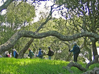
We began the hike passing the eastern end of the dam and then climbing a short, steep "cow track" trail until it leveled out onto a narrow path skirting the edge of the lake. From here we could get a clear view south and west down the main arm of the lake. After less than a quarter mile, we turned east, crawled under a barbed wire fence (which may have marked the edge of the MMWD-owned land) and continued to along the shoreline of the reservoir. Although we passed an odd tree here and there, the terrain was mostly grassland carpeted with wildflowers running steeply down to the lake.

Another half mile or so of meandering along the lake front brought us to a forested point of land where we spotted woodpeckers and had to pick our way through the trees and brush as the trail began to fade out. After a tenth of a mile and twenty minutes of tedious "bushwhacking" we emerged from the woods and back out into open fields, tossed off our packs, shedded layers of outerwear, and took a drink out of our waterbottles. We continued eastward for another five minutes, then turned back to the north and hiked uphill near a creek, stopping to check out a"Mosquito Hawk" (aka "Crane Fly") which Wendy had captured. (Click here for Wendy's list of all of the flora and fauna spotted on this hike).

Swinging back to the east, we zig-zagged our way across the landscape for another tenth of a mile, then headed straight uphill until reaching a broad, flat meadow extending west towards our starting point. With wildflowers at our feet, and mountain peaks rising up all around us, we could have been in the Austrian alps ready to burst into a chorus of "The Hills Are Alive With The Sound of Music" or at least a yodel or two.

Instead of doing a musical Julie Andrews impersonation, we began a steady, steep ascent eastward. After fifteen minutes of walking straight up the fall line, some of us opted to plop down in a warm, sunny spot with scenic views back towards the Three Peaks area to the west. (The Panfiglio Ranch in the Three Peaks area has been preserved for perpetual agricultural use under a conservation easement given to the Marin Agricultural Land Trust in 2008).

Christina, Stan and Linda continued on for a bit further before finding a shady place for lunch while the rest of us trudged upward for another twenty minutes following Christina's husband, Chuck, who probably would have led us all the way to Petaluma if we hadn't gang tackled him a half mile later at the top of the ridge. From the "summit" we enjoyed a panorama extending south and east to San Francisco Bay and Mount Diablo, south to Mt. Tam, and west to Inverness Ridge.

(The Google Earth photo below looks the west from the "summit", over Three Peaks, and then west to Point Reyes; click on it to open a large image in your Web browser).


(Click on the panoramic photo below to open a larger image in your Web browser)

The "Summit Team" then descended the ridge to join the rest of the group for lunch. Around 12:45 PM we packed up our gear, and headed down the hill towards the lake. If we would have gone north and west, we probably could have shortened the walk back to our cars, but a phalanx of long-horned steers dissuaded us from going in that direction. Within fifteen minutes we were at the edge of the reservoir, "diving" under the barbed-wire fence again. In another fifteen minutes and a third of a mile of hiking we reached the parking lot and our waiting cars.

The weather was sunny, but the wind was sharp and cold as we began the hike and it was still breezy when we reached the lake again three hours after starting out. But the lunch spot was perfect, and overall the weather was much better than last Tuesday when we were whipped by rain and wind at Chimney Rock. (Lucky for us, we didn't do either the Chimney Rock or the Soulajule hikes this Tuesday. Winds at Point Reyes gusting up to 63 mph would have flattened us across the ground, and the breeze probably would have strong enough to blow us off the "summit" at Soulajule).

On this outing we only hiked about 3.5 miles (see the Google Earth photo below for our approximate route; click on it for a larger image) which took us three and a half hours with stops and out lunch break. At the parking lot we were about 300' above sea level; those of us who climbed all the way to the "summit" reached a height of just under 1,100'.


(Pictures taken by Dick Jordan during the Soulajule hike are on-line. You can view them in the mini-slideshow window on the "Meandering In Marin On Tuesdays" blog, or by clicking here to go directly to the Picasa Web album of photos from the latest hike).

(Most of us retraced our route back through Hicks Valley driving home from the trailhead. Dick was bound for Santa Rosa and headed over Wilson Hill to Petaluma. The following pictures and comments relate to his post-hike drive).

Over thirty-five years ago when I owned a French-built "Motobecane" 10-speed bike, I pushed it up one side of Wilson Hill and rode it down the other. Today I went straight at the intersection of the Petaluma-Marshall Road and Hicks Valley Road, put my foot on the gas pedal instead of a bike pedal, and easily ascended this 736' high mound where I could peer down into the Stubbs Vineyard Pinot Noir plantings in the valley below and to the west, and gaze over the green hills and off toward Petaluma to the east.

After spending a while enjoying the scenery and taking some more photos, I rode the steep grade to the bottom and followed the road until it joined and morphed into Chileno Valley Road. In a short while I passed a solitary llama in one field and grazing sheep in another before pulling over at San Antonio Creek (marking the Marin-Sonoma County line) to shoot some final pictures.

Continuing on along Chileno Valley Road until it met Western Avenue running westward from downtown Petaluma, I decided that even though I'd not had to huff and puff pushing a bike up Wilson Hill, I had scrambled several hundred feet up the trail above Soulajule Reservoir and had earned a mid-afternoon "treat" at Petaluma's "Tea Room" Cafe. So when I reached town, I parked my car and strode over to this informal eaterie and refilled my calorie tank with a large, moist and sweet chocolate cupcake washed down with a giant cup of latte that I had to raise to my lips with both hands to prevent spilling it down the front of my shirt.

(Dick's round-about trek home continued on Tuesday with a drive down the Valley of The Moon from Santa Rosa to the Town of Sonoma for wine tasting at Castle Vineyards and lunch at The Girl & The Fig bistro).