 Wendy is back East for a week, so there will be no "Meandering" hike on Tuesday, August 4th. (The next Tuesday outing will be August 11th). But Stan Walker will be leading a contingent of Monday and Tuesday hikes on a ramble through the Presidio of San Francisco, followed by lunch out. If you're interested in going, contact him via e-mail (swalkrn@comcast.net) or by phone (415 331-2803).
Friday, July 31, 2009
Meander on Monday (Not Tuesday) in the Presidio
Wendy is back East for a week, so there will be no "Meandering" hike on Tuesday, August 4th. (The next Tuesday outing will be August 11th). But Stan Walker will be leading a contingent of Monday and Tuesday hikes on a ramble through the Presidio of San Francisco, followed by lunch out. If you're interested in going, contact him via e-mail (swalkrn@comcast.net) or by phone (415 331-2803).Monday, July 27, 2009
"Final Exam" Hike Photos Now On-Line!
 Pictures taken by Dick Jordan during the Tomales Bay State Park "Final Exam" hike (July 21st) are now on-line.
You can view them in the mini-slideshow window in the "Meandering In Marin On Tuesdays" blog, or by clicking here to go directly to the Picasa Web album of photos from the latest hike. (Albums of photos from our hikes can be accessed by clicking on the links on the right-hand side of the blog).
Sunday, July 26, 2009
Muddy Hollow Trailhead Hike (7/28) Preview
 This week we return to Point Reyes National Seashore to do a loop hike from the Muddy Hollow Trailhead. Last July we did a shuttle hike ending our outing at the Limantour Beach parking lot. Later in the year, the National Parks Service closed the section of the trail that leads to Limantour and when we did the Muddy Hollow Trailhead hike again in December 2008, we followed the new route and looped back to our cars and the hike's starting point.
Here's Wendy's description of our upcoming hike: "This trail has been redone and the pond removed to create more wetlands. Now we can do this as a loop instead of a shuttle. Great views and, we hope, some birds! Last year the elk were already bugling the first week in August so with luck we’ll see and hear them. Note: this hike is longer than we usually do (about 7 miles), but last time we made it back on time."
Directions to the trailhead: Take Sir Francis Drake Boulevard west to Olema. Turn right on Route 1, then make an immediate left onto Bear Valley Road. Continue past Park Headquarters (turn in if you need a restroom, there are none at the trailhead) and go left on Limantour Road. When you see a paved road to the Hostel on the left, turn right on the dirt road to Muddy Hollow parking lot. Carpool from St. Rita at 8:55 am.
Weather forecast: As of Sunday, July 26, the National Weather Service forecast for this area was patchy fog before 11 am, otherwise mostly sunny with a high near 56. West southwest wind between 8 and 17 mph with gusts as high as 21 mph. (Click here for an updated forecast).
More on this hike: The Martins' book, Hiking Marin, was lasted updated in 2006, so it does not show the re-routed trail back to the Muddy Hollow Trailhead. But their hike "G7 Coast - Beach - Muddy Hollow Trails" does show the area where we'll be hiking. However, the Point Reyes National Seashore's North District Hiking Map does show the new loop trail and pegs the distance at exactly 7.0 miles. The following Google Earth image shows the area (click on it to open a large picture in your Web browser).

Friday, July 24, 2009
Sign Up For Fall "Meanders" Begins On August 3rd
 The College of Marin's Fall Community Education classes are now listed on-line. Here's the Monday and Tuesday schedule for the "Fall 1" and "Fall 2" series of hikes:
- The first Fall 1 class (Mon and Tues) meets at Samuel P. Taylor State Park
- Fall 1
- 6 Mondays, 9:45am-1:45pm
- Sept. 14-Oct. 19
- Fee $98
- Course #85124 EC
- 7 Tuesdays, 9:45am-1:45pm
- Sept. 8-Oct. 20
- Fee $115
- Course #85125 EC
- (You must register separately for the second Fall series)
- Fall 2
- 7 Mondays, 9:45am-1:45pm
- Oct. 26-Dec. 7
- Fee $115
- Course #85126 EC
- 7 Tuesdays, 9:45am-1:45pm
- Oct. 27-Dec. 8
- Fee $115
- Course #85127 EC
Thursday, July 23, 2009
How Now, Multi-Colored Cows?
After reading the blog post about our Bull Point hike on July 7th, Silvia Lange reminded Dick that an article in the Marin Agricultural Land Trust's newsletter explained why we have some many different colored cows in West Marin. Here's that article:
THE COLOR OF COWS
How now, brown cow—but why so few of them in Marin County? The answer involves economics, environment and, to a degree, successful marketing.
The cattle dotting our rolling hills are mostly black-and-white Holstein-Friesians, the chief dairy animal in California. There are many Black Angus, too, raised for beef and cross-breeding. You’ll spot brown-and-white Herefords, also raised for beef, and every once in a while someone experiments with an exotic breed—Texas Longhorn, Brahman, Charolais, or Limousin. What we seldom see in Marin are the “classic” picture-book dairy breeds of Guernsey and Jersey. There’s a reason for that.
Holstein-Friesian is a Dutch breed, large and rugged and sturdy. A market-weight cow will be as much as 1,250 pounds, and a full-grown bull weighs nearly a ton. These typically docile animals (though the bulls can be fierce; don’t tease them) are ideally suited for grazing on Marin’s grassy hills, as they have large middles and will consume large amounts of forage. Significantly for California dairy farmers, the fat content of Holstein milk is the lowest of any major dairy breed.
“With all the grass we have in West Marin, the English breeds like Hereford and Angus do really well because they were originally bred to thrive on English pastures,” points out rancher and current malt Board chair Sam Dolcini. “Holsteins are the workhorses of dairy breeds with a big engine designed to produce lots of milk. Jerseys are more like sports cars, with smaller and higher-revving engines that deliver more performance in the form of protein and fat.”
The dairying counties of New England are where you’ll see fawn-colored Guernseys and Jerseys. The dairy industry there produces high-fat-content milk for butter, cheese, and ice cream. The natural fat content of Guernsey milk is about five percent; Jerseys produce milk with even more fat, about 5.3 percent. Both breeds are smaller than Holstein-Friesians, and graze successfully on the rocky New England pastures.
In contrast, dairying in California since World War II has been chiefly a commodity industry structured to produce low-cost milk for drinking rather than high-fat milk for processing into cheese and other dairy products. That’s why Holstein-Friesian dominates here. While Marin cheese production has lately blossomed, this development is too recent and not yet large enough
to impact the choice of cattle. Elsewhere in California, commodity milk production is the primary feature of the dairy industry, which means Holstein-Friesians are always readily available to California dairy farmers, including farmers in Marin.
Everyone knows that Black Angus produce flavorful, tender beef. We know this because of a highly effective marketing campaign carried out by the Certified Angus Beef organization. “They’ve done such a good job that now a lot of the black cattle you see aren’t Angus at all,” says Sam. “There are black Limousin and Gelbviehs too. Black is perceived by a lot of people to be a color of quality, and breeders are responding to that.” Angus are good breeders, and they’re used as crossbreeders not just to impart color but to improve milk quality and breed out horns. They carry the dominant gene for natural “polling,” or hornlessness. Horns can cause bruises and other wounds in a riled-up herd.
The Hereford steer, with rusty brown on the sides and back and white on the belly, face, and tail switch, is one of the primary beef animals in the United States. It’s a very old breed, originating from English cattle raised in Herefordshire that were cross-bred with Flemish cattle. They were originally used as draft animals on English farms due to their enormous strength and size of up to 3,000 pounds.
“Every once in a while someone tries something new out here,” says Sam. “There are a few Shorthorns, which is another English breed, in West Marin too. There have been a few Longhorns on occasion, and there are even a few Brahma cattle with the big humpy
backs out near Nicasio right now. If you find out what those cattle are doing out there, let me know!”
—(By Steve Bjerklie)
![Reblog this post [with Zemanta]](http://img.zemanta.com/reblog_e.png?x-id=67e65977-f61f-40a4-87a1-c2621b454419)
THE COLOR OF COWS
How now, brown cow—but why so few of them in Marin County? The answer involves economics, environment and, to a degree, successful marketing.
The cattle dotting our rolling hills are mostly black-and-white Holstein-Friesians, the chief dairy animal in California. There are many Black Angus, too, raised for beef and cross-breeding. You’ll spot brown-and-white Herefords, also raised for beef, and every once in a while someone experiments with an exotic
 breed—Texas Longhorn, Brahman, Charolais, or Limousin. What we seldom see in Marin are the “classic” picture-book dairy breeds of Guernsey and Jersey. There’s a reason for that.
Holstein-Friesian is a Dutch breed, large and rugged and sturdy. A market-weight cow will be as much as 1,250 pounds, and a full-grown bull weighs nearly a ton. These typically docile animals (though the bulls can be fierce; don’t tease them) are ideally suited for grazing on Marin’s grassy hills, as they have large middles and will consume large amounts of forage. Significantly for California dairy farmers, the fat content of Holstein milk is the lowest of any major dairy breed.
“With all the grass we have in West Marin, the English breeds like Hereford and Angus do really well because they were originally bred to thrive on English pastures,” points out rancher and current malt Board chair Sam Dolcini. “Holsteins are the workhorses of dairy breeds with a big engine designed to produce lots of milk. Jerseys are more like sports cars, with smaller and higher-revving engines that deliver more performance in the form of protein and fat.”
The dairying counties of New England are where you’ll see fawn-colored Guernseys and Jerseys. The dairy industry there produces high-fat-content milk for butter, cheese, and ice cream. The natural fat content of Guernsey milk is about five percent; Jerseys produce milk with even more fat, about 5.3 percent. Both breeds are smaller than Holstein-Friesians, and graze successfully on the rocky New England pastures.
In contrast, dairying in California since World War II has been chiefly a commodity industry structured to produce low-cost milk for drinking rather than high-fat milk for processing into cheese and other dairy products. That’s why Holstein-Friesian dominates here. While Marin cheese production has lately blossomed, this development is too recent and not yet large enough
to impact the choice of cattle. Elsewhere in California, commodity
 milk production is the primary feature of the dairy industry, which means Holstein-Friesians are always readily available to California dairy farmers, including farmers in Marin.
Everyone knows that Black Angus produce flavorful, tender beef. We know this because of a highly effective marketing campaign carried out by the Certified Angus Beef organization. “They’ve done such a good job that now a lot of the black cattle you see aren’t Angus at all,” says Sam. “There are black Limousin and Gelbviehs too. Black is perceived by a lot of people to be a color of quality, and breeders are responding to that.” Angus are good breeders, and they’re used as crossbreeders not just to impart color but to improve milk quality and breed out horns. They carry the dominant gene for natural “polling,” or hornlessness. Horns can cause bruises and other wounds in a riled-up herd.
The Hereford steer, with rusty brown on the sides and back and white on the belly, face, and tail switch, is one of the primary beef animals in the United States. It’s a very old breed, originating from English cattle raised in Herefordshire that were cross-bred with Flemish cattle. They were originally used as draft animals on English farms due to their enormous strength and size of up to 3,000 pounds.
“Every once in a while someone tries something new out here,” says Sam. “There are a few Shorthorns, which is another English breed, in West Marin too. There have been a few Longhorns on occasion, and there are even a few Brahma cattle with the big humpy
backs out near Nicasio right now. If you find out what those cattle are doing out there, let me know!”
—(By Steve Bjerklie)
Wednesday, July 22, 2009
Die Schulpfkuchen Vas Zehr Gut!
 Let's see, what did we have to eat at yesterday's "FinalExam"? Soup (Dick has no imagination), Mighty Ape Wraps, Chicken Satay, Potato Salad, Curried Veggies, etc., etc.
Of course, the piece de resistance, as usual, was Wendy's dessert.
Here's the recipe:
SCHLUPFKUCHEN
( Roe Doulgas' recipe)
(1 g = 0.35 ounces)
150g butter (room temperature)
150g sugar
150g flour, 1 tsp. baking powder (sifted together)
3 eggs (separate yolk from white)
Grated lemon rind !!!
Cherries (or experiment with other fruit)
Beat egg whites (with a pinch of salt) until stiff and reserve in refrigerator.
Beat butter and sugar; then add egg yolks, one at a time, until mixture is fluffy. Now continue mixing gently by hand.
Add lemon peel and then, bit by bit, the sifted flour/baking powder. Finally, gently incorporate the stiff egg whites.
Quickly and gently spread the dough in a buttered baking pan (one from which you can remove the rim after baking) and cover with plenty of pitted cherries. Very lightly push cherries into dough. (Also good with blueberries!)
Bake at 350º for 40-50 minutes.
Going "Ape" Over The Final Exam (July 21) Lunch
Although the skies were cloudy and the wind came up a bit, we eleven hikers managed to sit still long enough to scarf up lots of good eats and polish off nearly two bottles of wine before hitting the trail back to the parking lot. (If you're reading this in an e-mail, you may or may not be able to see and view the following videoclip. If you can't see it, and your e-mail program has a "Show Images" button, try clicking on that).
For his contribution to the "Final Exam" lunch during our Tomales Bay State Park, Nate brought this dish:
Mighty Ape Wrap
Ingredients:
La Tortilla Factory Hand Made Style Corn Tortillas (available at Safeway)
Fresh Ground Peanut Butter (Whole Foods)
Haig's Traditional Hummus (Whole Foods)
Marinated Kale (Whole Foods Salad Bar)
Black stringy seaweed (Whole Foods Salad Bar)
Assembly:
Spread a generous gob of peanut butter on Tortilla, followed by a generous gob of hummus.
Lay on some marinated kale and seaweed.
Roll.
Enjoy!
(Click here for view and print Dick's "Summer Gazpacho" soup recipe).
Monday, July 20, 2009
Winter in Summer (Bull Point, July 7)
Ah yes, hiking out in Point Reyes in the summer. Little chance of getting a tan, and even a fleece bikini wouldn't keep you warm on  Ocean Beach on a day like the one we had when we did the Bull Point hike on July 7th. When we were standing around the parking lot in jackets and wool hats before setting out on the hike it was overcast and probably less than 60 degrees. Thankfully, the breeze petered out within an hour and although the sun never broke through the marine layer, it turned out to be a decent enough day for
  hiking especially since there is hardly a tree along the entire route and on a bright, sunny day we probably would have been grousing about how damn hot it was.
About twenty minutes after we left the trailhead, Wendy turned back to the north away from the trail and led us cross-country looking for a rare lily-like flower which she finally located in a boggy-area not far from the road. Then we backtracked to the old ranch road that leads out to Bull Point and began heading south again.
This area is actively grazed (no wonder it's called the Bull Point trail) and we would have been well-advised to have carried John Pukite's A Field Guide to Cows along with us. (Dick's wife, who works for the Marin Agricultural Land Trust, keeps a copy at home). We saw White Cows with Pink Noses ("Charolais"), White Cows with Black Noses ("British White"), Black or Black-Brownish Cows with White Faces ("Black Baldy", a cross between Angus and Hereford), and other cows with black and white, or black and brown coats that could be a cross between these breeds.
For about half an hour we followed the road steadily upward along the edge of the "mesa" that leads to Bull Point. Creamery Bay lay below us to the east with much of its muddy bottom exposed by the low tide. After reaching the top of the hill we continued toward Bull Point and had a fine view south and west to the mouth of Drake's Estero. We turned left and headed toward Schooner Bay, dodging the grazing and lazing cows along the path. When we reached the bay, we swung back around to the north and looked out across the bay to the oyster beds maintained by local rancher and oysterman, Kevin Lunny.
Just as the clock struck mid-day, we descended the short distance from the headland to the beach and found a comfortable spot for lunch. Wendy spotted a bat ray splashing off-shore (net bags protect the oysters from being eaten by the rays) and we could see all of the way up the far end of the bay where the road runs from Inverness Ridge out to Point Reyes Lighthouse. After a half hour break, we were retracing our steps b ack to the parking lot and dodging cows and cow pies again. The day had warmed up a bit, so we started shedding some of the layers that we'd piled on at the beginning of the outing. But the sun still never came out while we were hiking.
About an hour later we were nearly back to our cars when we spotted a couple of interesting and probably rare beetles meandering their way down the trail. We covered the 4.0 mile route at a leisurely rate, with a fair amount of lolly gagging along the way. After all, we weren't in a foot race, but just meandering!
 Ocean Beach on a day like the one we had when we did the Bull Point hike on July 7th. When we were standing around the parking lot in jackets and wool hats before setting out on the hike it was overcast and probably less than 60 degrees. Thankfully, the breeze petered out within an hour and although the sun never broke through the marine layer, it turned out to be a decent enough day for
  hiking especially since there is hardly a tree along the entire route and on a bright, sunny day we probably would have been grousing about how damn hot it was.
About twenty minutes after we left the trailhead, Wendy turned back to the north away from the trail and led us cross-country looking for a rare lily-like flower which she finally located in a boggy-area not far from the road.
 Then we backtracked to the old ranch road that leads out to Bull Point and began heading south again.
This area is actively grazed (no wonder it's called the Bull Point trail) and we would have been well-advised to have carried John Pukite's A Field Guide to Cows along with us. (Dick's wife, who works for the Marin Agricultural Land Trust, keeps a copy at home). We saw White Cows with Pink Noses ("Charolais"), White Cows with Black Noses ("British White"), Black or Black-Brownish Cows with White Faces ("Black Baldy", a cross between Angus and Hereford), and other cows with black and white, or black and brown coats that could be
 a cross between these breeds.
For about half an hour we followed the road steadily upward along the edge of the "mesa" that leads to Bull Point. Creamery Bay lay below us to the east with much of its muddy bottom exposed by the low tide. After reaching the top of the hill we continued toward
 Bull Point and had a fine view south and west to the mouth of Drake's Estero. We turned left and headed toward Schooner Bay, dodging the grazing and lazing cows along the path. When we reached the bay, we swung back around to the north and looked out across the bay to the oyster beds maintained by local rancher and oysterman, Kevin Lunny.
Just as the clock struck mid-day, we descended the short distance from the headland to the beach and found a comfortable spot for lunch. Wendy spotted a bat ray splashing off-shore (net bags protect the oysters from being eaten by the rays) and we could see all of the way up the far end of the bay where the road runs from Inverness Ridge out to Point Reyes Lighthouse. After a half hour break, we were retracing our steps b
 ack to the parking lot and dodging cows and cow pies again. The day had warmed up a bit, so we started shedding some of the layers that we'd piled on at the beginning of the outing. But the sun still never came out while we were hiking.
About an hour later we were nearly back to our cars when we spotted a couple of interesting and probably rare beetles meandering their way down the trail. We covered the 4.0 mile route at a leisurely rate, with a fair amount of lolly gagging along the way. After all, we weren't in a foot race, but just meandering!
Saturday, July 18, 2009
It's Foggy, It Must Be Summer! (Bull Point, July 7)
 Pictures taken by Dick Jordan during the Bull Point hike (July 7th) are now on-line.
You can view them in the mini-slideshow window in the "Meandering In Marin On Tuesdays" blog, or by clicking here to go directly to the Picasa Web album of photos from the latest hike. (Albums of photos from our hikes can be accessed by clicking on the links on the right-hand side of the blog).
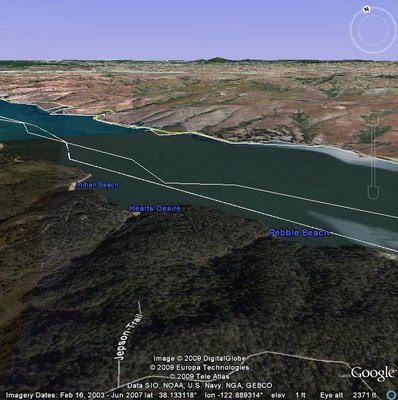
Tomales Bay State Park "Final Exam" Hike (July 21) Preview
It's the end of the first half of "summer school" this coming week when we return to Tomales Bay State Park for our hike. Here's Wendy's description of the outing: "Bishop pine forest, beach, and a favorite scenic picnic spot over-looking Tomales Bay. Bring something to share for our gourmet potluck lunch, and utensils, plate, and cup.
Directions to the trailhead: Take Sir Francis Drake Boulevard. Turn right at Olema and make an immediate left onto Bear Valley Road. (Stop at the Bear Valley Visitor Center to use the restrooms as there are none at the trailhead).
Continue until you pick up Sir Francis Drake Boulevard. Go through Inverness and over the ridge. At the "Y" where the road veers left to Drake's Beach and the Lighthouse go straight. This puts you on Pierce Point Road.
Just BEFORE the right turn that takes you down to Heart's Desire Beach there is a dirt parking lot on the right. If you don't know it you may need to go to the road to Heart's Desire and then turn around. We'll take the Jepson/Johnson loop.
Driving time one hour from College of Marin. Restrooms before lunch. Carpool leaves St. Rita at 9:00 am.
Weather forecast: As of Saturday, July 18, the National Weather Service forecast for this area on Tuesday, July 21st was for patchy fog before 11 am, otherwise partly sunny with a high near 61. (Click here for an updated forecast).
More on this hike: "G14 Johnstone - Jepson Trails" in the Martins' book, Hiking Marin, shows the area in which we'll be hiking. The trails are also shown on page 4 of the Tomales Bay State Park brochure. The Google Earth image below shows this part of the state park. (Click on the image to open a larger version in your Web browser).

Friday, July 17, 2009
Let's Meander to the Moon, Shall We?
On July 20, 1969, Neil Armstrong became the first human to walk on the Moon. (Not one of our typical, meanders). A Boston Globe article on this historic event inspired Dick Jordan to write the following bit about where he was meandering on that date. (Where were you at that time? Let us know by adding a "Comment" to this blog post).
Here's Dick reminiscence:
" restaurant taking a lunch break from work at the secret military installation on in the Pacific Ocean where I was 'employed' as an enlisted member of the U.S. Air Force. There were lots of restaurants, stores, and movie theaters on the island, and it was populated by thousands of "locals", as well as U.S. military personnel and their families. I could drive for twenty or thirty miles along the north-south axis of the island in my little two-cylinder Toyota which was like a soup can powered by a Singer sewing machine. But at that historic moment in time, I felt so far away from home that I might as well have been on the Moon, not just a fifteen-hour plane ride away from the West Coast of the U.S.
As a kid growing up in the '50's I was certain that one day soon I would be able to travel not just to the Moon, but to Mars for sure, and probably to a lot of other planets and galaxies as well. I read Robert Heinlein's science fiction novels and watched "Tom Corbett - Space Cadet" on TV. My friend Karl and I formed the "RK Rocket Club". We took the tops off ballpoint pens, stuffed the bottom part full of paper matches, then lit the heads and watched our "rockets" rocket along the sidewalk. We shot off "Pop-Bottle" rockets on the Fourth of July. But, of course, we never got to the Moon, or Mars, or anywhere else "off-planet".
Today, fifty years later, I realize I won’t be doing any interplanetary travel in my lifetime and that the odds of even being able to watch a modern-day astronaut do so is slim and none. But this is no longer that big of a deal to me. After all, there are no Rick Steves guidebooks to the solar system, and I can't use my frequent-flyer miles to get a free ticket to any of its planets."
Here's Dick reminiscence:
"
 restaurant taking a lunch break from work at the secret military installation on in the Pacific Ocean where I was 'employed' as an enlisted member of the U.S. Air Force. There were lots of restaurants, stores, and movie theaters on the island, and it was populated by thousands of "locals", as well as U.S. military personnel and their families. I could drive for twenty or thirty miles along the north-south axis of the island in my little two-cylinder Toyota which was like a soup can powered by a Singer sewing machine. But at that historic moment in time, I felt so far away from home that I might as well have been on the Moon, not just a fifteen-hour plane ride away from the West Coast of the U.S.
As a kid growing up in the '50's I was certain that one day soon I would be able to travel not just to the Moon, but to Mars for sure, and probably to a lot of other planets and galaxies as well. I read Robert Heinlein's science fiction novels and watched "Tom Corbett - Space Cadet" on TV. My friend Karl and I formed the "RK Rocket Club". We took the tops off ballpoint pens, stuffed the bottom part full of paper matches, then lit the heads and watched our "rockets" rocket along the sidewalk. We shot off "Pop-Bottle" rockets on the Fourth of July. But, of course, we never got to the Moon, or Mars, or anywhere else "off-planet".
Today, fifty years later, I realize I won’t be doing any interplanetary travel in my lifetime and that the odds of even being able to watch a modern-day astronaut do so is slim and none. But this is no longer that big of a deal to me. After all, there are no Rick Steves guidebooks to the solar system, and I can't use my frequent-flyer miles to get a free ticket to any of its planets."
Monday, July 13, 2009
Dick Jordan's Next Travel Story Appears August 2nd
 Dick Jordan's "staycation" story on the Bay Model in Sausalito will appear on the new "Bay & Beyond" page of the Marin I-J Travel Section on Sunday, August 2nd. The piece will probablyrun in the Contra Costa Times and possibly other Bay Area News Group newspapers such as the San Jose Mercury News. The I-J Travel Section isn't on-line, but the Contra Costa Times should have it posted on their Web site.
Friday, July 10, 2009
NEW S ALERT! Wait On Ordering from The Meandering On-Line Store
If you were planning on placing an order at the Meandering in Marin On-Line Store, hold off for a while. Theresa Fisher wasn't entirely happy with the products she ordered, and we may have to adjust the designs on the clothing items. (Nothing is ever simple, is it?).
Dick Jordan will let you know when we've resolved these problems.
Dick Jordan will let you know when we've resolved these problems.
Thursday, July 9, 2009
Hike & Wine in Sonoma (Monday, July 13)
 The fact that there are no "official" Meandering hikes this coming week (Wendy is out of town) has not deterred the die-hard Monday group from hitting the trail and they have invited the Tuesday hikers to join them for hiking, wining, and dining near the Town of Sonoma. (If you plan on going, please RSVP to peggespike@yahoo.com or call Pegge Spike at (415) 382-0416 since they need to make a reservation at the restaurant for the post-hike lunch).
Here are the details per an e-mail from Pegge:
"The hike is on the grounds of the Bartholomew Park Winery at the end of Castle Road. [Click here for a map that shows the winery in relation to the Town of Sonoma].
We will meet at the parking lot behind the Barracks [part of Sonoma State Historic Park] just off the Plaza. (Click here for a location map which you can zoom in on).
From Marin: 101 North to Hwy 37 toward Vallejo.
About 5-6 miles to Hwy 121 to Sonoma--a left turn by the Infineon Raceway.
About 6-7 miles and Hwy 121 curves to the right [and heads towards Napa].
About 1 mile and Route 12 turns to the left to Sonoma proper. This (12) is Broadway and it ends at the Plaza/City Hall after about 5 miles.
At end of Broadway turn right--go to stop sign and turn left. You will pass the
Sebastiani Theatre [on your right]. Continue to stop sign [the Sonoma Mission is on the right at this corner].
Go straight for about half a block to city parking lot on left. We will car pool to the trailhead.
Call Anne if you get lost (510) 333-3886.
I think we should aim for the usual meeting time of 9:45. There are restrooms near the parking lot. We are in no big rush since the hike is about 2 hours or a little less.
It could be hot, but about 3/4 of the trail is under trees. [As of Thursday, July 9, the National Weather Service forecast for this area on Monday, July 13 was sunny with a high near 89. Click here for an updated forecast].
There is a lot of up and down and the trail can be slippery with gravel. Recommend good tread and hiking poles for those who usually use them. There is a chance to bail out before the last big "up." There are restrooms at the end of the trail...and, of course, the winery. Nice tasting room.
Our usual lunch place has been EDK (El Dorado Kitchen). A little upscale but we are worth it. There are others with outside tables. Might depend upon our numbers so can decide
later.
Wish there were wildflowers and water in the creek...alas, not at this time. The views are nice and the company the best.
Cheers to you and all!
Anne"
[The Google Earth image below shows the hills surrounding the Bartholomew Park Winery. Click on the image to open a larger version in your Web browser].

Sunday, July 5, 2009
Bill Dreskin Featured Photographer at New Gallery!
 Photographs by Wendy's husband, Bill (shown in the photo at left as he hiked with us at Palomarin recently) will be featured at a newly opened art gallery called "The Coastside"in Half Moon Bay. The art of several painters and work by two other photographers will be displayed as well. The Coastside is open 10 am to 5 PM (it may be closed Tuesdays) and will focus on art that reflects the beauty of California's Pacific coast shoreline, hills, and ranches.
The gallery is located at 300 Main Street in lovely Zaballa Square. Adjacent galleries offer high quality art glass and beautiful woodworking. Gift shops and good restaurants serving lunch and dinner are nearby. (Click here for more information on visiting Half Moon Bay).
Friday, July 3, 2009
NEW! Grand Opening of the Meandering in Marin On-Line Store!
 Welcome to the Grand Opening of The Meandering in Marin On-Line Store!
Our store features over thirty items of apparel, including T-shirts, sweatshirts, and hats sporting our Famous Logo designed by Christina
 Oldenburg. (Clothing comes in "unisex", men's, and women's sizes)
Drink your favorite hot beverage from one of our
 mugs bearing the Meandering in Marin Photo Collage, or "Drink While You Drive" using our commuter cup. Or let your computer mouse meander across our mousepad while you consult our Year-At-A-Glance calendar to remind you to send a personal note to your favorite relative using our Acorn Woodpecker notecards designed by Theresa Fisher. And we have even more merchandise in our on-line store!
Our store is strictly non-for-profit, run by CafePress.com, and designed for the use and benefit of the Monday and Tuesday Meandering in Marin hikers. (The general public can't find our store using Google or other search engines).
You can place your order on-line using a credit card and have your favorite items shipped directly to you. But unlike shopping until you're dropping at the mall, as a Meandering in Marin On-line Store customer you pay the same "wholesale" price (plus tax and shipping) that you would be charged if you were running a store and buying merchandise from CafePress.com to mark-up and sell at a profit in your own money-making venture.
CafePress.com offers a 30-day money back guarantee on all products. If you would like to return or exchange an item, please contact CafePress.com to fill out a request form, and they will send you an RMA and instructions on how to send the item(s) back. (Shipping charges are not refundable).
Click here to shop at the Meandering in Marin On-Line Store (or copy paste the store's Web address into your Web browser: www.cafepress.com/meanderingmarin).
Any questions? If so, send an e-mail to Dick Jordan of the Tuesday group who set up the store for us.
Thursday, July 2, 2009
Vacation "On The Farm" in England in 2010
 Tour Organic Farms in England
June 15-25, 2010
Britain has long been at the forefront of the organic farming movement, thanks in part to Prince Charles' passionate involvement. As a benefit for MALT, Inverness resident and MALT supporter Paul Coopersmith has designed "Organic Farms, Private Gardens & Country House Hotels," a 10-day tour offered June 15-25, 2010, by his company, Coopersmith's One-of-a-Kind Tours™. Visit some of England's most celebrated organic farms and beautiful private gardens, Prince Charles' Duchy Home Farm (where the photo of piggies was taken by MALT's Elisabeth Ptak) and Highgrove House among them. (Click here for the full itinerary).
Limited to 20 people, the tour price includes a $250/person tax-deductible donation to MALT, to be matched by a $250/person contribution from Coopersmith's. For further information, contact Paul at 415-669-1914 or paul@coopersmiths.com
Hike A Little, Eat a Lot (Heart's Desire to Shell Beach)
There are two ways to hike from Heart's Desire to Shell Beach in Tomales Bay State Park: The long way (5.6 miles) or the short  way (3.1) miles. The short way sounded like a good choice since we planned to eat out in a restaurant after the hike. But in retrospect, the long way would have required us to burn more calories before lunch and be much hungrier when we finally sat down to eat. In any event, we took the Lazy Man's Hike, thereby eliminating 2.5 miles and 500' of elevation gain.
Our group shrunk again this week with only seven of us joining Wendy for this relatively easy walk. After leaving cars at the Shell Beach parking lot, we headed out Pierce Point Road about 1 mile from the "Y" and pulled off to park.
During our usual pre-hike confab, Susan regaled us with stories of the "Southern Belles" she met during her recent trip to Virginia. We then set off downhill on the Jepson Trail towards Heart's Desire Beach, but after a tenth of a mile, we made a sharp turn to the north, crossed a paved road that leads down into the park, and continued on the Johnstone Trail.
The Bishop Pine forest and understory along this trail is quite thick. At times, it was like walking through hedgerows on a narrow path. Apparently the tall pines capture moisture from fog blowing in from the ocean and, in the process, provide a natural "drip irrigation" system watering the plants growing under the forest canopy. Although Summer had formally begun, we still found a couple mushrooms alive and well along the trail. We normally see few if any hikers on Tuesdays, but another large group headed in the opposite direction passed us in two waves.
After about a mile-plus, the Johnstone Trail begins a long, slow half-mile descent to Shell Beach. By the time we were headed downhill, the sun had burned off the marine layer and the weather was quite pleasant. Although the beach is no doubt quite crowded, on Tuesday there were just a couple of guys lounging around on the sand, a lone woman talking on a cell phone (you just can't get away from it, can you?) a little farther down the beach, and two kayakers paddlin
 g south just off-shore.
After hanging out on the beach for a while to look for butterflies and bugs, we continued along the shore for another quarter mile or less, then climbed back up to the parking lot to ferry drivers back to our starting point. Once all of the cars and hikers had been retrieved, we drove back to Olema for a leisurely and civilized lunch out on the deck of the Farm House restaurant. At the end of the meal, the servers brought out a decadent chocolate dessert with a candle for Stan, who was celebrating his 144th birthday (he only looks half his age!).
 way (3.1) miles. The short way sounded like a good choice since we planned to eat out in a restaurant after the hike. But in retrospect, the long way would have required us to burn more calories before lunch and be much hungrier when we finally sat down to eat. In any event, we took the Lazy Man's Hike, thereby eliminating 2.5 miles and 500' of elevation gain.
Our group shrunk again this week with only seven of us joining Wendy for this relatively easy walk. After leaving cars at the Shell Beach parking lot, we headed out Pierce Point Road about 1 mile from the "Y" and pulled off to park.
During our usual pre-hike confab, Susan regaled us with stories of the "Southern Belles" she met during her recent trip to Virginia. We then set off downhill on the Jepson Trail towards Heart's Desire Beach, but after a tenth of a mile, we made a sharp turn to the north, crossed a paved road that leads down into the park, and
 continued on the Johnstone Trail.
The Bishop Pine forest and understory along this trail is quite thick. At times, it was like walking through hedgerows on a narrow path. Apparently the tall pines capture moisture from fog blowing in from the ocean and, in the process, provide a natural "drip irrigation" system watering the plants growing under the forest canopy. Although Summer had formally begun, we still found a couple mushrooms alive and well along the trail. We normally see few if any hikers on Tuesdays, but another large group headed in the opposite direction passed us in two waves.
After about a mile-plus, the Johnstone Trail begins a long, slow half-mile descent to Shell Beach. By the time we were headed
 downhill, the sun had burned off the marine layer and the weather was quite pleasant. Although the beach is no doubt quite crowded, on Tuesday there were just a couple of guys lounging around on the sand, a lone woman talking on a cell phone (you just can't get away from it, can you?) a little farther down the beach, and two kayakers paddlin
 g south just off-shore.
After hanging out on the beach for a while to look for butterflies and bugs, we continued along the shore for another quarter mile or less, then climbed back up to the parking lot to ferry drivers back to our starting point. Once all of the cars and hikers had been retrieved, we drove back to Olema for a leisurely and civilized lunch out on the deck of the Farm House restaurant. At the end of the meal, the servers brought out a decadent chocolate dessert with a candle for Stan, who was celebrating his 144th birthday (he only looks half his age!).
Bull Point (July 8) Hike Preview
This week we head through Inverness, but go farther west to hike in the Point Reyes National Seashore rather than in Tomales Bay State Park. Here's Wendy's description for this hike: "A beautiful but soggy (in places) walk timed to see the coast lily blooming at its only site in Marin! Other endangered flowers we’ve seen other years include the swamp harebell, large-flowered Linanthus, and Point Reyes checkerbloom. We may also see yellow-eyed grass, tinker's penny, white-flowered bog orchid, and Hooker’s evening primrose. Some off trail walking but very little elevation gain." (Click here to check out what we saw the last time we did this hike on July 8, 2008).
Directions to the trailhead: Take Sir Francis Drake Boulevard west to Olema. Turn right on Highway 1, then make an immediate left onto Bear Valley Road. Continue past the road to Park Headquarters (stop here for a restroom break; there are no porta-potties at the trailhead) and go left when you hit Sir Francis Drake again. Go through Inverness. Go left at the "Y" (right takes you out to Pierce Point) and pass MCI and RCA stations on your right. The Bull Point parking lot will be on your left.
Carpool leaves St. Rita at 8:50 am.
Weather forecast: As of Thursday, July 2nd, the National Weather Service forecast for this area on Tuesday, July 8th was for patchy fog before 11am, otherwise mostly sunny with a high near 56. (Click here for an updated forecast).
More on this hike: Hike "H11 Bull Point and South Beach Trails" in the Martins' book, Hiking Marin, shows this as 4.0 mile out and back hike. Tracy Salcedo-Chourre's book, Exploring Point Reyes National Seashore and Golden Gate National Recreation Area, pegs it at 3.6 miles as does the park's North District Hiking Map. The Google Earth image below shows the area where we'll be hiking. (Click on the image to open a larger version in your Web browser).

Subscribe to:
Posts (Atom)