Saturday, January 28, 2012

Winter 2012 Hike Schedule Now Online

You'll find a listing of all Winter 2012 Meandering on Tuesdays hikes on the "Upcoming Hikes" page of the Meandering blog.

Click here to view and print the schedule and details for all of the hikes if you did not receive it via e-mail from Wendy or "snail mail" from the College of Marin.

The first hike is the Blithedale Canyon Loop on Tuesday, January 31st.


Blithedale Canyon Loop Hike (Jan 31) Preview

This week we head to the the eastern side of Southern Marin near Mill Valley.

Here's Wendy's description of the hike:  "A loop with great views of Mt. Tamalpais! We should see the beautiful Mist Maidens, Mission Bells, and huckleberry and Star Lillies in bloom. Probably a 9 fern day!"

(Click here to read a re-cap of our 2010 hike.  View the online album of photos taken on past hikes on these trails).

Directions to trailhead: Take East Blithedale exit from Highway 101. Where you cross Throckmorton it becomes West Blithedale. Go 0.9 miles and look for parking at Marsh Drive and West Blithedale on both the left and the right sides of the street. (Click here for a map and driving directions).

Time: 30 minutes from COM. Carpoolers can meet at the Greenbrae Parking & Ride lot at 9:10 a.m. No restrooms at trailhead. 

Weather forecast:  As of Saturday, January 28, the National Weather Service forecast for Tuesday's hike was partly sunny, with a high near 59.  (Click here for an updated forecast).

More on this hike: Hike "B1 Blithedale Ridge - Corte Madera Trails" in the Martins' book, Hiking Marin, shows the area we will be hiking in although our route may differ slightly from the one they set out for their hike. (This area is also shown on the maps of the Marin County Open Space District's Baltimore Canyon Preserve and Blithedale Summit Preserve).

This Google Earth image shows Marsh Drive and West Blithedale Avenue in Mill Valley where we'll meet to start our hike. We'll head up to the ridge at the top of the picture (which looks east over Corte Madera and Larkspur to the Richmond-San Rafael Bridge), hike along it, then double back to our starting point. (Click on the photo to open a larger image in your Web browser).


Friday, January 20, 2012

Sky Oaks to Deer Park “Final Exam” (1/24) Preview

Downhill and level! Maybe we’ll see some of milkmaids that we saw on the Sky Trail to Bear Valley hike last Tuesday!  (Click here for a recap of the hike we did in October of 2009).

Remember to bring plate, utensils, cups, and a delicious dish to share at the post-hike luncheon.

This is a shuttle hike, so CALL WENDY AT 457-3949 or send her an e-mail her at bdreskin@comcast.net if you are coming!

Directions to trailhead:  Meet at Deer Park to carpool. Take Bolinas Avenue in Fairfax, turn left on Porteous. (If you see Deer Park Villa you’ve gone a bit too far, turn around.) Go to the parking lot at the end. Drivers leave food in cars at Deer Park.  Shuttle drivers will take us to the parking area just beyond the Sky Oaks pay station and leave their cars there.
 
The day use fee is $8.  You can use $1, $5, or $10 bills and coins at the automated pay station, or a Visa or Mastercard. Annual entrance passes are normally $60 ($30 for those 62 and older), but after September 1st you can buy one for half of those prices and the pass will be valid through January 31, 2012.  (You can pay the annual pass fee at the automated pay station.  Keep one part of the receipt which is a temporary pass good for two weeks, then: 1) stop at the Sky Oaks Ranger Station on the way out and ask them to send the other half of your receipt to the main office in Corte Madera which will issue the permanent pass and mail it to you, or 2) send or take the receipt to the main office yourself).

Restrooms at Deer Park and portable at Sky Oaks, and porta-potty en route. Carpool from St. Rita Church in Fairfax at 9:25 a.m.

Weather forecast:  As of Friday, January 20, the National Weather Service forecast for the hike was partly sunny with a high near 58.  (Click here for an updated forecast).

More on this hike:  The Martins' book, Hiking Marin, does not have a hike that matches this one.  But their hikes "C 12 Taylor-Concrete Pipe-Bullfrog FR" and "C7 Deer Park FR-Canyon-Six Points" shows the the general area where we will be hiking as does the MMWD watershed trail map.

Wednesday, January 11, 2012

Sky Trail to Bear Valley Hike (1/17) Preview

Uphill Slog - Sky Trail We return to Point Reyes National Seashore this week for our next to the last Winter 2011-2012 outing

The trail is about 7.3 miles long, but a lot of it is fairly level, so it's a bit easier than the distance implies. This is a shuttle hike, so CALL WENDY AT 457-3949 or send her an e-mail her at bdreskin@comcast.net if you are coming! Note the earlier than usual meeting time at Bear Valley.

Directions to trailhead: We’ll meet at Bear Valley at 9:20 a.m. and carpool to Sky Trail.  When we get to Mt. Wittenberg we’ll go down Old Pine to the Bear Valley Trail. We’ll need some people who are not in a rush to drive people back to Sky Trail after we reach the Bear Valley Visitor Center and parking lot.

Restrooms at Bear Valley, none at Sky Trail trailhead, but some as we pass Coast Camp.

Carpool leaves St. Rita Church in Fairfax at 8:45 a.m.

Weather forecast: As of Wednesday evening, January 11, the National Weather Service forecast for the hike was mostly sunny with a high near 53.  (Click here for an updated forecast).

More on this hike:  "G3 Sky Trailhead to Bear Valley" in the Martins' book, Hiking Marin, is a version of this hike although we usually go straight at Junction #1 shown on their map and continue on to Sky Camp rather than take the detour up to Mt. Wittenberg (which we do on a separate loop hike from the Sky Trail trailhead) and then back down to the Sky Trail before continuing on to the Old Pine Trail, Divide Meadow and on to Bear Valley.  (Click here for the Seashore's South District Hiking Map which shows these trails).

The following Google Earth image gives a bird's eye view of where we'll be hiking:


Sunday, January 8, 2012

San Geronimo Ridge Hike (1/10) Preview

On this hike, we will pass through a pygmy Sargaent cypress area, grasslands, and redwood habitat. There are muddy spots if it has rained, so wear hiking boots and waterproof them.

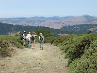
There is an elevation gain of about 600 feet, but most of the hike is along the ridgeline with sweeping views north and south.

This is a shuttle hike, so CALL WENDY AT 457-3949 or send her an e-mail her at bdreskin@comcast.net if you are coming!

Directions to meeting point:  Meet 0.2 miles past the Shafter Bridge (and Cronin Fish Viewing Area parking lot) in Samuel P. Taylor State Park. There is some parking along the road here. We'll leave some cars and carpool to Conifer Way in Woodacre.  No restrooms at trailhead. Carpool from St. Rita Church in Fairfax at 9:20 a.m.
Directions to trailhead from meeting point:  For those who will drive to the trailhead from the meeting point, here are directions to Conifer Way: Go east on Sir Francis Drake Boulevard. Turn right on Railroad Avenue.

Set your odometer when you turn right on Carson Road. At the 0.6 mile mark you will see a sign saying Ivy that makes you think the name of the street as changed.

Go right and you will still be on Carson.

Go 0.2 miles to the junction of Carson and Conifer Way. (There is another junction of Carson and Conifer which you will pass and ignore.) Cars that can do an "unmaintained road" (i.e., one fukll of big potholes) can turn left on Conifer Way and go to the top to park. Others with low clearance (like the Prius!) park at Carson and Conifer and we'll walk up.

Weather forecast:  As of Sunday, January 18, the National Weather Service forecast for the hike was a 20 percent chance of showers, but mostly sunny, with a high near 60. West northwest wind between 6 and 16 mph, with gusts as high as 21 mph. (Click here for an updated forecast).

More on this hike:  On this outing we'll be hiking through the County of Marin's Gary Giacomini Open Space Preserve. After starting up the Conifer Fire Road,we'll head west along the San Geronimo Ridge Fire Road. (Click here for the MCOS District map which shows these trails). Barry Spitz' book, Open Spaces: Lands of the Marin County Open Space District, discusses this area.

The following Google Earth image shows the area we'll be hiking through; click on it to open a larger image in your Web browser: