Sunday, July 29, 2012

Palomarin Hike (7/31) Preview

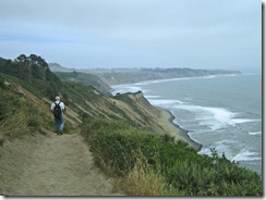
Looking South to BolinasWe resume our summer hikes this coming week with another trip to Point Reyes National Seashore, this time beginning at the far southern end of the park at the Palomarin trailhead near Bolinas.

Here's Wendy's description of this outing: "This hike is not a loop, but has incredible ocean views making it well worth the drive! We should see bee plant, seep-spring monkey flower, salmonberries as well as butterflies and dragonflies. Lunch at Bass Lake." (Click here for a recap of our July 2010 hike ).

Directions to the trailhead: Take Sir Francis Drake Boulevard west to Olema. Turn left (south) on Route 1. Pass Five Brooks and Dogtown, and take the unmarked right turn (on to Horseshoe Hill Road which merges with the Olema-Bolinas Road) towards the town of Bolinas. (If you find yourself going along the shore of Bolinas Lagoon, you've driven too far south and missed the turn.) Turn right on Mesa Road (which eventually becomes a dirt road) and follow it to the Palomarin trailhead parking lot.

Carpool leaves St. Rita at 8:40 a.m.

If you're coming from southern Marin you may prefer to take Route 1 north, turning left just past the end of the lagoon onto the unmarked road into the town of Bolinas, then right on to Mesa Road to get to the trailhead.

Toilets at the trailhead. If you can't wait, use the porta-potties at Five Brooks, a right turn off Highway 1 for those coming south from Olema, or for those heading north from southern Marin, turn left off the highway into Muir Beach or at the ocean overlook just to the north.

Weather forecast:  As of Sunday, July 29, the National Weather Service forecast for the hike was  patchy fog before 11am. Otherwise, mostly sunny, with a high near 68. West wind around 10 mph. (Click here for an updated forecast).

More on this hike: The "F17 Coast Trail to Wildcat Camp" hike in the Martin's book, Hiking Marin, is 11 miles long, but shows the route that we'll take up to Bass Lake, 2.7 miles from the trailhead. (The 8.5 mile "Alamere Falls and Double Point Overlook" hike in Tracy Salcedo-Chourre's Exploring Point Reyes National Seashore and Golden Gate National Recreation Area says the distance to the north shore of the lake is 2.9 miles, while the park's South District Hiking Map pegs it at 2.8 miles).  We’ll retrace our steps back to the trailhead after lunch so our total hiking distance will be around 5.5-6.0 miles.

Friday, July 20, 2012

Tomales Bay State Park "Final Exam" Hike (July 24) Preview

It's the end of the first half of "summer school" this coming week when we return to Tomales Bay State Park for our hike.

Here's Wendy's description of the outing: "Bishop pine forest, beach, and a favorite scenic picnic spot over-looking Tomales Bay. Bring something to share for our gourmet potluck lunch, and utensils, plate, and cup.

(Click here to view photos from past hikes in Tomales Bay State Park).

Directions to the trailhead: Take Sir Francis Drake Boulevard. Turn right at Olema and make an immediate left onto Bear Valley Road. (Stop at the Bear Valley Visitor Center to use the restrooms as there are none at the trailhead).

Continue until you pick up Sir Francis Drake Boulevard. Go through Inverness and over the ridge. At the "Y" where the road veers left to Drake's Beach and the Lighthouse go straight. This puts you on Pierce Point Road.

Just BEFORE the right turn that takes you down to Heart's Desire Beach there is a dirt parking lot on the right. If you don't know it you may need to go to the road to Heart's Desire and then turn around. We'll take the Jepson/Johnson loop.

Driving time one hour from College of Marin. Restrooms before lunch. Carpool leaves St. Rita at 9:00 am.

Weather forecast: As of Friday, July 20, the National Weather Service forecast for the hike was for patchy fog before 11 am, otherwise partly sunny with a high near 63. (Click here for an updated forecast).

More on this hike: "G14 Johnstone - Jepson Trails" in the Martins' book, Hiking Marin, shows the area in which we'll be hiking. The trails are also shown on page 4 of the Tomales Bay State Park brochure. The Google Earth image below shows this part of the state park. (Click on the image to open a larger version in your Web browser).

Thursday, July 12, 2012

TUESDAY, JULY 17 - NO HIKE!

There will be no hike on Tuesday, July 17th. 

But if you want to see how Muddy Hollow has changed since we hiked it six weeks earlier on May 29th, come on Monday, July 18th and carpool from St. Rita's at 8:55 a.m. or meet at the Muddy Hollow Trailhead at 9:45 a.m.

Our next Tuesday hike will be July 24 - Final Exam Tomales Bay State Park Shuttle Hike.

Wednesday, July 11, 2012

Angel Island Hike Photos Now Online!

A slideshow of photos from yesterday's Angel Island hike is now online! You can view the photo slideshow in this post on the Meandering blog or on the Meandering YouTube Channel.


To play the video at the highest quality, click on the "Gear" icon on the right-hand side of the bar at the bottom of the YouTube player and select 1080pHD under “Quality.” Toggle between smaller and larger video player windows by clicking on the small and large rectangles on the bar. Click on the 4-cornered icon on the bar to play the video full-screen on your computer.


Saturday, July 7, 2012

JULY 31 - AUG 28 HIKE SCHEDULE NOW ONLINE!

Details for all Tuesday Meandering hikes from July 31st through August 28, 2012 is now online! Click here to view and print out this information.

Click here to review the list of dates and locations only for Tuesday hikes from July 10 through August 28th.

Registration for both the Fall 1 (Sept. 4 - Oct. 16) and Fall 2 (Oct. 30 - Dec. 11) College of Marin hiking series opens on Monday, August 6th.

Wednesday, July 4, 2012

Angel Island Hike (7/10) Preview

Angel Island State Park hasn't been closed (at least not yet), so we'll head there for our next summer hike.  Here's Wendy's description of the outing: Angel Island is often good for butterflies like Anise Swallowtails, Western Tiger Swallowtails, California Sisters, and Pipevine Swallowtails!We'll go to the top of Mt. Livermore, eat lunch there, and take the last ferry of the day back at 3:30 p.m.

Directions to the ferry dock: We'll take the 10 a.m. ferry from Tiburon to the island. Bring cash or check (credit cards not accepted) for the ferry ($13.50 round trip,  pay as you board, includes the $3.00 park entrance fee which you can save if you have a State Park day pass). (Bring $17 in cash or check for Wendy, too!)

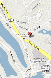
Allow time to park and don't miss the boat! (Although it's only 10-minute trip, the next ferry doesn't run until 11:00 a.m.). The ferry dock is at 21 Main Street. Parking gets more expensive the closer you get to the ferry. There is sometimes on-street free parking if you make a left on Mar West, the corner the library is on. (See map at left). Allow ten minutes to walk (click here to view and print Mapquest walking directions) from there to the ferry.

Here is a map of parking lots (cash only, no credit or debit cards, accepted) and the ferry dock provided by the Angel Island Association and the ferry operator:


Restrooms at ferry in Tiburon and on Angel Island. Carpool from Greenbrae Park and Ride at 9:15 a.m.

Weather forecast: As Wednesday, July 4th, the National Weather Service forecast for Angel Island on Tuesday, July 10 was sunny, with a high near 67. (Click here for an updated forecast).

More information on this hike: The Martin's book, Hiking Marin, sets out two hikes on the island: "A12 North Ridge Trail to Mt. Livermore" and "A13 Angel Island Perimeter Trail."

Click here to go to the Angel Island State Park page on the California State Park's Web site. Click here for on-line information provided by the Angel Island Conservancy.

You'll find a map of the island on page 4 of the state park brochure. To listen to a podcast about Angel Island, click here.

If you have a smartphone, you can get one of free CalParks mobile apps, available for iPhone and Android.

Here's a Google Earth bird's eye view of the island:


Bull Point Hike Photos Now Online!

A slideshow of photos from yesterday's Bull Point hike is now online! You can view the photo slideshow in this post on the Meandering blog or on the Meandering YouTube Channel.


Tuesday, July 3, 2012

Toluma Farms Goat Dairy Virtual Tour

On Sunday, July 1st, Dick Jordan toured the Toluma Farms goat dairy located between Tomales and Dillon Beach.

The dairy is open for tours (call or e-mail ahead of time) at 1 pm on the first Sunday of the month.

Wear your hiking boats and clothes that you don't mind the goats munching on if they want to see what you taste like!

Tours last about an hour and a half.  Click here for more information.

The dairy hopes to open its creamery soon and begin making its own cheese.  (Right now all of its milk is sold to Redwood Hill Farm whose cheese are sold at several grocery stores in Marin.)


This map shows the farm's location. (Click here if the map does not display in the e-mail you received.)