Tuesday, October 28, 2014

A Grand Day at Point Reyes

The weather couldn't have been better for our last "Fall 2" hike out at Point Reyes today.

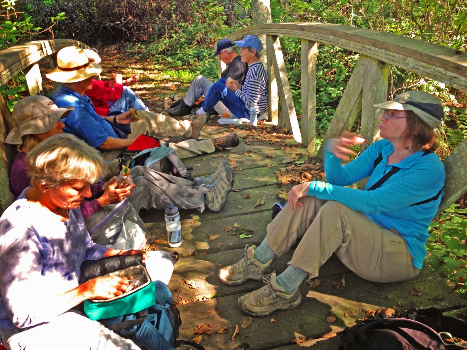
Alas, our "Official Photographer," Theresa Fisher, wasn't along, so you'll have to make do with this iPhone photo taken by Dick Jordan at our lunch stop.


(Click here for photos from past hikes on these trails).

Friday, October 24, 2014

CHANGE TO FALL HIKE LIST

Third time is a charm.

Here's what hopefully is the final revision to the Fall 1 & 2 Hike List.

UPDATED HIKE LIST


The first hike of the "Fall 2" series has been changed, so click here to get a complete list of all Fall 1 & Fall 2 hikes that was updated as of October 24, 2014.

Laguna Trailhead Hike (October 28) Preview

Note: This week's hike was originally to take place at Samuel P. Taylor State Park, but that plan was changed due to closure of the trail we were to hike. "Plan B" was to do Bootjack to Mt. Theater to West Point Inn, but that's also been scrapped and we'll be headed out to Point Reyes National Seashore instead.


This week as we repeat a hike we did last February when Marge filled in for Wendy and we saw scads of woodrat nests: "Today we take a different route from a familiar trailhead to make a 4.6 mile loop. We get our exercise on the uphill before lunch and then stroll downhill to complete the loop."

Directions: Take Sir Francis Drake Boulevard west to Olema. Turn right on Route 1, then make an immediate left onto Bear Valley Road.

Continue past Park Headquarters (turn in if you need a restroom; there are none at the trailhead) and go left on Limantour Road. Turn left at the sign for the youth hostel. Follow that road until you see a right turn across a bridge to the Laguna Trailhead by the Clem Miller Education Center. Park in the parking lot.

To cut half a mile off the hike, turn right instead of left at the sign for the youth hostel, leave your car at the Muddy Hollow parking lot and ride with a friend across the Limantour Road to the trailhead.

Click here for a MapQuest Map that shows the Muddy Hollow area, and click on #1 to get driving time and directions from your location.

55 minutes from College of Marin. Carpoolers can meet at St. Rita Church in Fairfax at 8:55 a.m.

No restrooms at trailhead.

Weather Forecast: As of Friday, October 24th, the National Weather Service forecast for the hike was mostly sunny, with a high near 66. (Click here for an updated forecast).

More on this hike: Hike "G5 Bayview - Muddy Hollow - Laguna" in the Martin's book, Hiking Marin, shows the route we'll take. (Point 1 on their map shows where you'll leave your car to cut 0.5 miles off the hike. Point 2 is where we'll leave the other cars and actually begin hiking.)

Tuesday, October 14, 2014

NO HIKE ON OCTOBER 21ST

Enjoy a week off hiking on Tuesday, October 21st, following the last hike of "Fall 1" today.


We'll resume our weekly treks around the county on October 28th as "Fall 2" begins with a hike on Mount Tam from Bootjack to Mountain Theater to West Point Inn and back.

Wednesday, October 8, 2014

REVISED FALL 1 & 2 HIKE LIST

Since Bill's Trail in Samuel P. Taylor State Park is closed, we won't be able to hike in Devil's Gulch on October 28th as originally planned.

Instead, we'll do the Bootjack to Mountain Theater (with a lunch stop at West Point Inn) hike.

Click here to view and print a revised list of all Fall 1 & 2 hikes.

China Camp: A New Hike

Trail construction and closure forced us to ditch both "Plan A" and "Plan B" for hiking yesterday at China Camp State Park.


Instead of the routes we've taken in the past, this time we parked along San Pedro Road at the park entrance that leads to the Back Ranch campground, discovered that we had to pay $3/person or have park pass just to hike in that section of the park, and headed up the Bay View Trail and Powerline Fire Road.


Fortunately, although the sun was shining on the hillsides and the temperature was warm, there was enough shade to keep our brains from being baked into adobe bricks.

We topped out at about 700' above sea level, now and then being rewarded with sweeping views to the north across San Pablo Bay toward Sonoma and Napa.

Steeply descending the Back Ranch Fire Trail brought us to picnic tables in the campground near the bottom of the hill, leaving us just a short walk back to our cars after lunch.

(Hike "D14 Bay View Trail - Miwok Fire Trail" in the Martin's book, Hiking Marin, shows these trails we walked, although we didn't follow the entire route for that specific hike.)


Tennessee Valley "Final Exam" Hike (10/14) Preview

Down In The Valley Per Wendy, "this loop [around Tennessee Valley] features panoramic views of the Bay. We often see Condominium spiders, and raptors --- including Northern Harriers, American Kestrels, White-Tailed Kites, Red-Shouldered Hawks and Red-Tailed Hawks. When we're lucky we see bobcats!"

REMEMBER TO BRING PLATE, UTENSILS, AND SOMETHING TO SHARE FOR THE GOURMET FINAL EXAM! (Let’s think green and try to cut down on paper and plastic throw-aways as much as possible). We’ll leave the food in the cars and eat when we get back, but bring your water bottle. 

(Click here for a recap of our October 2008 hike. Here's an album of photos from past hikes in this area.).

Directions to trailhead: Take the Stinson Beach exit from Highway 101. Follow signs to Stinson Beach and Muir Woods, then turn left on Tennessee Valley Road and take it to the parking lot at the end.

(Click here for a MapQuest map showing the trailhead. Click on #1 to get driving time and directions from your location.)

40 minutes from College of Marin.

Carpoolers can meet at the Greenbrae Park & Ride lot 9:15 am.  (Click here for a MapQuest map showing the parking lot; click on #1 to get driving time and directions from your location.)

Portable toilets at the trailhead and lunch.

Weather forecast: As of Wednesday, October 8th, the National Weather Service forecast for the hike was partly sunny, with a high near 72.  (Click here for an updated forecast)..

More information on this hike: Hike A8 Miwok – Coyote Ridge – Coastal Trails in the Martin's book, Hiking Marin, shows our route from Tennessee Valley towards Mill Valley, westward to ocean views, then back east to the parking lot.

Friday, October 3, 2014

Mountain Home to Muir Woods Hike Photos Now Online!

Photos taken by Theresa Fisher and Dick Jordan during this week's Mountain Home to Muir Woods hike are now online!

View them on the Meandering blog or click here for the on-line album.

Wednesday, October 1, 2014

China Camp State Park Hike (10/7) Preview

Wetlands To The North This week we hike on the eastern edge of Marin along San Francisco Bay, this time venturing into China Camp State Park. (Click here to read about our November 2008 hike or here for photos from past hikes in this area.)
 
Here's Wendy's description of the outing:
"Learn about wetland habitats and some of the endangered animals that live there like the tiny salt marsh harvest mouse. This area is also of historical interest as the site of a once thriving Chinese shrimp fishing village." (Click here to view and print out the park brochure and map).

Directions to trailhead: Take the San Pedro Road exit from Highway 101 and go east for three miles. PASS the sign that says China Camp State Park and go about 3/4 mile further on San Pedro Road to Miwok Meadows (sign on your right). Park along the road, not inside of the park entrance as Wendy's list of hikes directs.


Click here for a map that shows the parking area along San Pedro Road. Click on #1 to get driving times and directions from your location. 

Time: 30 minutes from College of Marin.

Carpoolers coming from San Rafael or farther north can meet at 9:15 am at the Park & Ride lot on the east side of Highway 101 at Smith Ranch Road in the Terra Linda area north of the Marin Civic Center and downtown San Rafael.

Carpoolers coming from south of San Rafael can meet at Greenbrae Park & Ride lot at 9:15 a.m. (Click here for a MapQuest map showing the parking lot; click on #1 to get driving time and directions from your location.)

No restrooms at trailhead, but you can turn in at the China Camp State Park sign and go past the toll booth (you don't need to pay), past the day use parking area, and to the campground parking area.

Weather forecast: As of Wednesday, October 1st, the weather forecast for the hike was Patchy fog before 11am. Otherwise, sunny, with a high near 76. (Click here for an updated forecast).

More on this hike: Hikes "D13 Miwork - Oak Ridge - Shoreline Trails" and “D14 Bay View Trail – Miwok Fire Trail" in the Martins' book, Hiking Marin show the general area where we will be hiking although our route may vary from the ones they describe due to closure of the Miwok Fire Road.

Estero Trail Panoramic Photos

Theresa Fisher wasn't on last week's Estero Trail hike out at Point Reyes National Seashore, but here are a few panoramic photos that Dick Jordan shot.