Friday, February 27, 2015

Deer Park to Phoenix Lake Hike (3/3) Preview

This is a scenic hike with lunch at Phoenix Lake.  We should see Red Larkspur, Gypsum Spring Beauty, Baby Blue Eyes, and Ground Iris  Maybe we'll hear the first Orange-Crowned Warblers of the season!  (Click here for a recap of our hike in March 2010 or here for photos from past hikes.)

Directions to trailhead:  Go west on Sir Francis Drake Boulevard to Fairfax. As you enter Fairfax, turn left at the gas station, and make an immediate right in front of the movie theater. This puts you on Broadway. Make the first left onto Bolinas Avenue. Just after it veers left, turn left on Porteous Avenue. Follow it to the parking lot at Deer Park.

(Click here for a MapQuest map showing the location of Deer Park; click on #1 to get driving directions and estimated driving time from your location.)

15 minutes from College of Marin. Carpoolers can meet at St. Rita's Church at 9:30 a.m.

Restrooms at trailhead.

Weather forecast:  As of Friday, February 27th, the National Weather Service forecast for the hike was a slight chance of showers. Mostly sunny, with a high near 65. (Click here for an updated forecast).

More on this hike: Presumably we'll follow the same route as in the past. The Martin's Hiking in Marin trail guide does not have a single map and directions for our hike from Deer Park School to Phoenix Lake and back, but you can use the following two maps and hikes from their book to piece together our path:

Start off using the Martin's Hike "C6 - Deer Park Road - Yolanda Trail." Head up the Deer Park Fire Road to Oak Tree Junction, then turn left (to the south) and hike uphill on the Six Points Trail. When you reach the Six Points junction, switch to Hike "C4 - Hidden Meadow - Yolanda Trail" and hike down the Yolanda South Trail to Phoenix Lake.

Using that same hike and map, follow Shaver Grade uphill, and while doing so, refer back to the C6 hike and map to follow the Grade to Five Corners. Continue straight down Deer Park Fire Road to Boy Scout Junction. Cross the fire road and take the Junction Trail back to its intersection with Deer Park Fire Road (just where you turned off onto Six Points Trail when you were headed toward the lake).

Here's a Google Earth view looking from Deer Park over Bald Hill towards Phoenix Lake.


(Click on the photo to open a larger image in your Web browser).

We'll hike from north to south, following the blue line in this picture to reach the lake, where we'll have lunch. Then we'll head south to north along the red line to return to where we began.

(Click here for a printable map of the MMWD watershed which shows these trails.)

 This trail profile shows that we'll be doing a lot of up and downhill hiking.


Monday, February 23, 2015

Corrected Spring 2015 Hike Details

As noted in a blog post earlier today, the dates for the first and last hikes in the detailed schedule for Spring 2015 which Wendy had sent out last week by e-mail were incorrect.


Click here to view, download or print an updated version of that schedule which has the correct dates, plus all of the other details for each hike.

Dick Jordan's "Saving Seals By The Seashore" to Air on MarinTV


Dick Jordan's 10th "short" for public access television, "Saving Seals By The Seashore," filmed at The Marine Mammal Center and Point Reyes National Seashore, airs on MarinTV (Comcast cable in Central/Southern Marin County, California) on:

+     Thu    02/26/15    07:00 PM    Channel 26
+    Wed    03/04/15    07:00 PM    Channel 26

February 27 update: Due to technical problems at MarinTV, Dick's show did not air as scheduled on Thursday, February 26th. Hopefully it will be broadcast on March 4th or other dates in the future.

Don't live in that cable service area? Don't have a DVR?

No problem, you can watch it on YouTube.

You'll see some familiar faces toward the end of this three-minute video.

Spring Hikes; Steep Ravine Trail

Just a quick reminder that registration for the College of Marin Spring Meandering in Marin hike series opened today, Monday, February 23rd. Click here to sign up online.


The detailed itinerary for those hikes which Wendy e-mailed last week contains two errors:
  1. The first hike, West Ridgecrest on Mount Tam, will be on Tuesday, March 31 (not April 1, which is a Wednesday).
  2. The last hike, the Rock Spring "Final Exam," will be on Tuesday, May 12 (not May 11, which is a Monday).
The Friends of Mt. Tam Website (http://www.friendsofmttam.org/) says that the Steep Ravine trail (which we'll hike on Tuesday, April 7) has been reopened.


Wednesday, February 18, 2015

A Sunless Blithedale Canyon Loop Hike

Good news, bad news, on yesterday's Blithedale Canyon Loop hike.

Good news, the sun never came out, so we weren't sweating as we trekked uphill.

Bad news, the sun never came out, so the most colorful thing we saw (besides wildflowers) was graffiti scrawled on the water tanks along the fire road.


(If the video player doesn't appear in your e-mail, go to the blog to see a video clip shot during the hike.)

The wasn't much of a view across the Bay from our lunch stop, and the top of Mt. Tam was never cloud-free.

Indian Valley Open Space Hike (2/24) Preview

This coming week we head to Novato to hike near the Indian Valley campus of the College of Marin. (Note: Originally we planned to do the Steep Ravine hike on February 24th, but the trail is still closed due to damage from storms last December.)

Two loops combine to make an interesting hike. Wildflowers and early butterflies, and a stop at the tadpole/newt larvae pond.

 (Click here for a recap of our 2010 hike. You can view photos from past hikes by clicking here.)

Directions to trailhead: Take Highway 101 to the Ignacio Boulevard exit. Go west and follow Ignacio Boulevard into the Indian Valley College campus.

(Click here for a MapQuest map that shows the parking area. Click on #1 to get driving time and directions from your location.)

Our hike starts from parking lot #6 by the athletic field. (Click here to view and print a map of the campus).  


Bring a singles or dozen quarters (credit card may work, too) to get a ticket from the parking machines ($3/day). 25 minutes from College of Marin.

Carpoolers can meet at Smith Ranch Park & Ride lot at 9:15 a.m.

Restrooms at trailhead.

Weather forecast: As of Wednesday, February 18th, the National Weather Service forecast for the hike was sunny, with a high near 65. (Click here for an updated forecast).

More on this hike: Two hikes in the Martin's book, Hiking Marin, cover the area that we'll traverse: "E6 Indian Valley FR - Waterfall Trail" and "E7 Schwindt - Wildcat Trails".

You can also view and print the map for the Marin County Open Space District's Indian Valley preserve. (Click here for more information about the Indian Valley Open Space Preserve.)

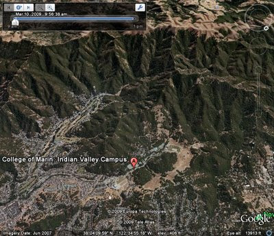
The Google Earth photo below shows this area. (Click on the photo to open a larger image in your Web browser).

Saturday, February 14, 2015

Spring COM Meandering Hiking Series Sign-Up Coming Soon

Registration for the Spring 2015 Meandering in Marin Hiking series will open on Monday, February 23rd.

The Tuesday class (Course # 0451) will run from March 31st through May 12th.

Monday hikes (Course #0450) will take place March 30th through May 11th.

Cost is $142 ($120 for Emeritus College members).

Two other COM classes may be of interest to Meanderers.

Petroglyphs of West Marin (Sat, 4/25; Course #0427; $75) will feature an introduction at the Museum of the American Indian in Novato, followed by a field trip to Mount Burdell, Nicasio, and Olema to look for petroglyphs.

Animal Tracking and Nature Awareness (Sat, 5/2; Course #0428; $75) will be a half-day (8 am - noon) workshop held at Abbott's Lagoon to look for animal tracks and signs.

Click here for more information and to register online.


Friday, February 13, 2015

Blithedale Canyon Loop Hike (Feb 17) Preview

This week we head to the the eastern side of Southern Marin near Mill Valley.

Here's Wendy's description of the hike:  "A loop with great views of Mt. Tamalpais! Early wildflowers and probably a 9 fern day!" (Click here to read a re-cap of our 2010 hike.  View the online album of photos taken on past hikes on these trails).

Directions to trailhead: Take East Blithedale exit from Highway 101. Where you cross Throckmorton it becomes West Blithedale. Go 0.9 miles and look for parking at Marsh Drive and West Blithedale on both the left and the right sides of the street.

Click here for a MapQuest map that shows the parking area near the trailhead. Click on #1 to get driving time and directions from your location.

Time: 30 minutes from COM. Carpoolers can meet at the Greenbrae Parking & Ride lot at 9:10 a.m. No restrooms at trailhead. 

Weather forecast:  As of Friday, February 13th, the National Weather Service forecast for Tuesday's hike was sunny, with a high near 69.  (Click here for an updated forecast).

More on this hike: Hike "B1 Blithedale Ridge - Corte Madera Trails" in the Martins' book, Hiking Marin, shows the area we will be hiking in although our route may differ slightly from the one they set out for their hike. (This area is also shown on the maps of the Marin County Open Space District's Baltimore Canyon Preserve and Blithedale Summit Preserve).

This Google Earth image shows Marsh Drive and West Blithedale Avenue in Mill Valley where we'll meet to start our hike. We'll head up to the ridge at the top of the picture (which looks east over Corte Madera and Larkspur to the Richmond-San Rafael Bridge), hike along it, then double back to our starting point. (Click on the photo to open a larger image in your Web browser).

Tuesday, February 3, 2015

Bootjack Hike (2/10) Preview

We continue the Winter 2015 College of Marin hiking series on the Bootjack Trail on Mount Tamalpais.

The hike description is simple: "A mostly shady trail opens up to an incredible vista at a sunny (we hope!) lunch spot overlooking the ocean! We'll take Bootjack Trail to Van Wyk Meadow, TCC Trail to the Dipsea Trail, and the Old Mine Trail back."

Click here for photos taken on past hikes along these trails.

This map shows the route we'll follow.


Here's the hike's profile showing the elevation changes.


 (Click on the Map or Profile to View a Larger Image)

Directions to trailhead: Take the Stinson Beach/Highway 1 exit off Highway 101. Go west through Tam Valley and up onto the ridge. Turn right onto Panoramic Highway and follow signs to Mt. Tamalpais.  

As you drive up the mountain, look for the Bootjack picnic area and parking lot ($8/car, if you don't have a state park pass) on your right. 

Click here for a MapQuest map that shows the Bootjack parking lot. Click on #1 to get driving directions and times from your location.

If you get to Pantoll at the crest of Panoramic Highway, you've gone too far and need to turn around and drive back down the mountain. (Click here for a map of Mt. Tam that you can view and print out)

50 minutes from the College of Marin. Carpoolers can meet at the Greenbrae Park & Ride lot at 9:00 am. Restrooms at trailhead.

Weather forecast: As of Tuesday, February 3rd, the National Weather Service forecast was sunny, with a high near 62. (Click here for an updated forecast.)

Dick Jordan's 10th TV "Short" For MarinTV

A Bird In The Hands, Dick Jordan's 10th television "short," will air on MarinTV (Comcast Channel 26) on:
  • Wednesday, February 4, 6:30 pm
  • Sunday, February 15, 8:30 pm
It's just 3 minutes long and was produced from still photos which Dick shot of a Bufflehead duck getting a "physical exam" by veterinary staff while Dick was talking a "backstage tour" of the Monterey Bay Aquarium last April.


Aren't a Comcast subscriber? Won't be home to watch the show live? Don't have a DVR?

No problem. You can watch A Bird In The Hands on Dick's YouTube Channel.