Tuesday, April 28, 2015

Wolf Ridge Hike (5/5) Preview

Here's Wendy's description of this annual Spring outing: "Wildflowers and views! 'First of spring' flowers for this hike usually include Cobweb Thistle and Bee Plant, and we sometimes see the amazing Fairy Moth hanging out by Oceanspray."  (Click here for a recap of our 2010 hike.  This is the on-line album of photos taken during our previous hikes in this area.)

Directions to trailhead: From Highway 101 south bound, take the last exit before the Golden Gate Bridge. Turn right, go under the freeway, and get in the left turn lane to go through the one way tunnel with the 5 minute traffic light.

Park at the end of the road. (Rodeo Beach will be on the other side of the road). (Click here for a MapQuest Map for driving directions and times from your location.)

Time: 40 minutes from COM.

Carpoolers can meet at Greenbrae Park & Ride lot at 9:15 a.m. (Click here for a MapQuest map showing the parking lot; click on #1 to get driving time and directions from your location.)

Restrooms at trailhead.

Weather forecast: As of Tuesday, April 28th, the National Weather Service forecast for this year’s hike was patchy fog after 11am. Otherwise, sunny, with a high near 64. (Click here for an updated forecast).

More on this hike: Hike "A5 Coastal - Wolf Ridge - Miwok Trails" in the Martins' book, Hiking Marin, shows our route for this 5 mile-plus hike with a 1,000' elevation gain, as does the "Coastal-Miwok Loop" hike in Tracy Salcedo-Chourre's book, Exploring Point Reyes National Seashore and Golden Gate National Recreation Area. (Hill 88, our probable lunch spot, is 960' above sea level with lovely views on a clear day).

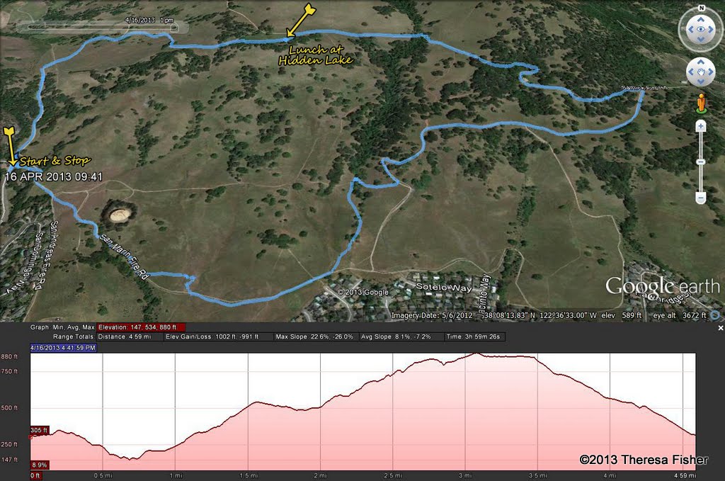
Here's the hike's elevation profile.


 This is the route that we'll follow.


The Google Earth photo below shows the area. (Click on it to open a larger image in your Web browser).


If you have time after the hike ends, stop by The Marine Mammal Center, just above the park road, east of Rodeo Beach. There should be a docent-led tour ($9 adults, $5 for those 65+) at 3:00 p.m. that day, but space is limited, so click here to register on-line to be sure to reserve a spot for yourself. (You can pay on the day of the tour if the tour isn't full.)


"The White Bag" Spy Thriller Spoof Is Out!

Luckily, you don't have to wait for the summer blockbuster movie season to see Dick Jordan as the "Ace of Spies" in the spy thriller spoof , "The White Bag," filmed on location in San Rafael.


Last week Dick finished editing his version of this not-to-be-missed flick that was produced by himself and other students in a class at the Community Media Center of Marin.

Hopefully, Dick's rendition of "The White Bag" will eventually air on MarinTV with other versions produced by his classmates, along with a "Making of 'The White Bag'" mini-documentary.

In the meantime, make yourself a small (the film is only about 3 minutes long) bowl of popcorn and enjoy this parody of Hollywood film noir movies of the 1950's.


(Click here if the YouTube player doesn't display)

Monday, April 27, 2015

Ridge to Bridge

Looking for a slightly more challenging hike than the ones we Meanderers do?

How about going over hill and dale for 26 miles, from the junction of the Bolinas-Fairfax Road and Ridgecrest Avenue on Mount Tam all the way across the Golden Gate Bridge to the Presidio of San Francisco?  (Click here for a map of the route.)

(Michael Fischer Photo)
If that makes your feet ache just thinking about it, not to worry. There's also an option to hike shorter segments.

One of Dick Jordan's fellow "gym rats" (the tall guy in this photo) covered the 18 miles to Tennessee Valley where he stopped for lunch and ended his hike five and half hours after a 6:38 a.m. start. (The guy in the yellow jacket, who also works out at the gym Dick Jordan frequents, continued on to the Presidio.)


You can also ride a bike or a horse instead of putting one foot in front of the other several thousand times.

More good news: You've got a full year to train for the 2016 "Ridge to Bridge" event! (The 19th annual edition took place this past Saturday.)

Wednesday, April 22, 2015

Green Gulch Hike (4/28) Preview

Here’s Wendy’s description for next week's hike:  “Today we get to see the beautiful organic vegetable garden at the Zen Center’s Green Gulch Farms on our way up to the Coyote Ridge Trail. Lunch overlooking the ocean on our way back down to Muir Beach.”  (Click here for a recap or here for the on-line album of photos from a previous hike on these trails).

Directions to trailhead:  Take the Stinson Beach/Highway 1 exit off Highway 101. Go through Tam Junction, and take Shoreline Highway and follow signs to Muir Beach. (Click here for a MapQuest map that shows the trailhead parking lot. Click on #1 to directions and driving times from your location.)

Time: 55 minutes from COM.

Carpoolers can meet at the Greenbrae Park and Ride lot at 9:00 a.m. (Click here for a MapQuest map showing the parking lot; click on #1 to get driving time and directions from your location.)

Restrooms at trailhead. 

Weather forecast: As of Wednesday, April 22nd,  the forecast for the day of the hike was mostly sunny, with a high near 68.  (Click here for an updated forecast).

More on this hike:  Although our actual route may vary, hike A10 (Coastal – Coyote Ridge – Green Gulch) in the Martins’ book, Hiking Marin, covers this area.  (Click here for more information on Green Gulch Farm).

 Here's the hike profile and the route we'll follow.


This Google Earth image shows the area where we will be hiking.

Green Gulch Google Earth View

Tuesday, April 14, 2015

"H Is For Hawk," Wednesday, April 15th in Point Reyes Station

At midnight tomorrow, Wednesday, April 15th, the time for procrastinating on paying Uncle Sam last year's taxes ends.

But at 7:00 pm (before or after you begrudging send off your loot to the IRS), you can attend a special "bird book" event at the Dance Palace in Point Reyes Station.

Here's what the program, sponsored by Point Reyes Books, is all about:

"Helen Macdonald’s H Is for Hawk is among the most anticipated works of nonfiction this spring. Winner of the 2014 Costa Book of the Year and the 2014 Samuel Johnson Prize for Nonfiction, it is the remarkable story of one woman’s resolve to raise and train the most bloodthirsty of birds: the goshawk.

"But it’s also a heart-wrenching account of Macdonald’s grief at the sudden death of her father; a literary meditation on The Sword and the Stone author T.H.White—a writer who also sought to fill a void through training a goshawk; a gripping piece of nature writing that “reads like a thriller” (The Guardian) and transports both writer and reader to the edge of humanity and back."

Click here to read more about the author and tomorrow night's reading.

Leapfrog Lunch on Mount Burdell

The weather was perfect for today's hike on Mount Burdell in Novato.

Hidden Lake, our lunch stop, was indeed hidden: All of the water which had recently been there had completely evaporated.


And the tadpoles that of late had been swimming in that vernal pond had turned into an abundant colony of tiny leaping frogs frolicking away while we enjoyed a sunny midday meal.

Chimney Rock (4/21) Hike Preview

We'll return to Point Reyes National Seashore for this hike which we do every year in Spring. (Click here for a recap of our 2010 trek.  You can also view photos taken on past hikes.)

Here's what Wendy promises for this outing: "This is one of Marin's must-see spring wildflower displays which includes some beautiful endangered flowers.

"We'll see Northern Elephant Seals at the overlook and take time to learn about their history and return from the brink of extinction. (Click here to watch Dick Jordan's "Saving Seals By The Seashore," a 3-minute "short" which aired on MarinTV.)

"We often see Piegon Guiillemots, Eared Grebes in breeding plumage, Common Loons, and Savannah Sparrows on this hike. Bring binoculars if you have them."

Directions to trailhead: Take Sir Francis Drake Boulevard to Olema. Turn right at Olema onto Highway 1, then make an immediate left onto Bear Valley Road.

There are restrooms at the trailhead --- another 30-45 minutes down the road; if you need a restroom break now, take the first left off Bear Valley Road and stop at the Bear Valley Visitor Center.

Continue on Bear Valley Road until you pick up Sir Francis Drake again.

Turn left to follow Sir Francis Drake out to Point Reyes. Go through Inverness.

At the junction with Pierce Point Road, bear left and stay on Sir Francis Drake. Follow signs towards the Lighthouse and Drake’s Beach. You’ll pass the turn to Drake’s Beach on your left.

Keep going until you see a left turn to Chimney Rock. (Sir Francis Drake continues on to end at the Lighthouse parking lot).

Driving time from the College of Marin: One hour, thirty minutes.  

Carpoolers can meet at St. Rita's Church in Fairfax at 8:30 am.

(Click here to get driving directions from your location and a MapQuest map showing the trailhead.) 

Weather forecast: As of Tuesday, April 14th, the National Weather Service forecast for the Point Reyes Lighthouse area was partly sunny, with a high near 58. (Click here for an updated forecast).

Real-time weather reporting for the Point Reyes Lighthouse is also available (click here). Sometimes it is very windy when we do this hike, so in addition to your rain gear (if the forecast changes), be sure to toss some extra layers and a warm jacket and hat (bring some duct tape to "tie" your hat on your head) in your car in case it is "blowin' like snot" (a sailor's term for windy weather).

More on this hike: The general area covered by this hike is shown in hike "G13 PR Lighthouse and Chimney Rock" in the Martin's book, Hiking Marin and the "Chimney Rock" hike in Tracy Salcedo-Chourre's book, Exploring Point Reyes National Seashore and Golden Gate National Recreation Area.

 Click here to view and print a copy of the park map for the Point Reyes National Seashore.

You can also view and print out a map of the Chimney Rock area from the Point Reyes National Seashore Web site.

Here's the hike profile.


Here's the route we'll follow.


The Google Earth image below shows where we'll be on this outing. (Click on the photo to open a larger image in your Web browser).

Wednesday, April 8, 2015

A New and Improved Steep Ravine Trail

Five of us (Wendy, her friend from Otto from Austria, Judy, Arthur, and Dick) correctly guessed that yesterday's heavy rain would stop before and not resume until well after the hike.

Tip: If the weather for a hike sounds like it might be wet and windy, go to the KTUV Channel 2 Website and check out the "FutureCast" which, unlike the National Weather Service Website, predicts cloud cover and rainfall hour by hour and may indicate that we'll be "high and dry" on the trail during the hike that day.


We five who managed to reach the trailhead (albeit 45 minutes late in Dick's case) despite the big traffic snafu on Highway 101 between San Rafael and Corte Madera and along Sir Francis Drake near the Greenbrae interchange discovered that it is now a bit easier to get up the Steep Ravine Trail to Pantoll.


A new bridge has replaced an older one that was wrecked by a falling tree during last December's storms.

(Alas, the other bridges that are missing boards or rotting away haven't been replaced yet.)


 The ladder that we have to ascend next to a waterfall looks to be brand new, too.


And downed trees that nearly blocked some sections of the trail have been removed.

Except for a bit of overcast during our lunch break, and some brisk winds as we crossed the meadows along the Dipsea trail, yesterday's weather was perfect for hiking in Steep Ravine, with a lot of sunshine.

Mount Burdell Open Space (4/14) Hike Preview

This week we head to the Novato area to hike on Mount Burdell.

Here's Wendy's description of the hike: "This loop takes us by Hidden Lake, which hopefully will have water from these later rains. We may see Cream Cups, Tidy Tips, Baby Stars, and Balloon Clover as well as seven or eight species of butterflies. This is the only spot where Bitterroot, the Montana state flower, grows in Marin."  (Click here for a recap of our 2009 hike. Click here for an album of photos from past hikes.)

Directions to trailhead: Take Highway 101 north and take the San Marin Drive exit. Go west on San Marin Drive. Turn right on San Andreas Drive. The entrance to the Open Space will be on your right.

If you come to the dead end of San Andreas you've only gone about half a block too far. No lot, but plenty of curbside parking.

Click here for a MapQuest map showing the trailhead location. Click on #1 to get driving time and directions from your location.

30 minutes from College of Marin.

Carpoolers can meet at 9:15 am at the Park & Ride lot on the east side of Highway 101 at Smith Ranch Road in the Terra Linda area north of the Marin Civic Center and downtown San Rafael. Click here for a MapQuest map showing the location of the lot. Click on #1 to get driving time and directions from your location.

No restrooms on this hike, but you can use the one at the Starbuck's in the shopping center at the intersection of San Marin Drive and San Andreas Drive, just down the street from the trailhead. (Click here to get a MapQuest map and driving directions.)

Weather forecast: As of Wednesday, April 8th, the National Weather Service forecast for the day of the hike was sunny, with a high near 65. (Click here for an updated forecast).

More on this hike: Hike "E13 Old Quarry Trail to Mt. Burdell" in the Martin's book, Hiking Marin, shows the general area that we'll be hiking in, although we'll probably turn left at intersection #2 and head directly to Hidden Lake rather than climb all of the way to the summit of the mountain as shown on the Martin's map.

Click here for a Mount Burdell Open Space Preserve map from the Marin County Open Space District's Web site.

Here's the vertical profile and route for the hike.


The Google Earth image below shows where we'll be hiking. (Click on the photo to open a larger image in your Web browser).

Saturday, April 4, 2015

River Otters Return

Last month while Meandering we saw river otters in both Phoenix and Bon Tempe lakes. (Below is the "Otter Spotter" report we filed with the River Otter Ecology Project.)

On Friday, ABC Channel 7 News in San Francisco reported on the return of river otters to the Bay Area during this interview featuring Dick Jordan's friend, Megan Isadore, co-founder of ROEP.

 
(Click here if the video doesn't display)

If you see river otters while you're out and about in the Bay Area, be sure to submit a report of your sighting to the River Otter Ecology Project.

Thursday, April 2, 2015

Steep Ravine to Dipsea Trail Hike (4/7) Preview

December rains damaged the trail, so this favorite February hike has been put off until now.

We usually see Giant Wake Robin, Redwood Evergreen Violets, Star Lilies, Smith’s Fairy Bells, Fetid Adder’s Tongue and Calypso Orchids during the winter; hopefully they'll still be there two months after we normally hike the area.

We’ll go up Steep Ravine since some of us find the ladder is easier to go up than down. Lunch at Pantoll.  (Click here for a recap of our 2010 hike).

Directions to the trailhead: Take the Stinson Beach/Highway 1 exit off Highway 101. Go through Tam Junction, stay on Route 1, and follow signs to Muir Beach.

Pass the road that goes to Muir Beach staying on Route 1 (towards Stinson Beach), pass Slide Ranch, and keep going until you see the locked gate for the Steep Ravine cabins on the west (left) side of the road. There is parking is on the east (right) side of Highway 1.

Click here for a MapQuest map that shows the location Steep Ravine Trailhead and parking area on Highway 1; click on #1 to get driving directions and time from your location.

Time: 1 hour 5 minutes from College of Marin.

No restrooms at trailhead, but you can turn in at Muir Beach (which has new pit toilets and a paved parking lot) en route and use the ones in the parking lot or the ones a bit farther north at the overlook on the left-hand side of the highway. 

Carpoolers can meet at the Greenbrae Park & Ride lot at 8:50 a.m.(Click here for a MapQuest map showing the parking lot; click on #1 to get driving time and directions from your location.)

Weather forecast: As of Thursday, April 2nd, the forecast for the hike was mostly cloudy, with a high near 61 and a chance of showers. (Click here for an updated forecast.)

More on this hike: If you have the Martins' book, Hiking Marin, look at their hike "B14 Dipsea - Steep Ravine Trails" which starts at Pantoll, goes down the Dipsea, up Steep Ravine, and ends back at Pantoll.

Since we're beginning and ending our outing down on Highway 1, our hike will be slightly longer, but basically the reverse of the Martins' hike. (Page 6 of the Mt. Tam State Park brochure has a park map that you can "zoom in" on to see these trails).