Friday, March 31, 2017

Spring Hike Details Now Online!


Details for all of the Spring 2017 Meandering on Tuesdays hikes are now online.


Click here to view and print them out.

Thursday, March 30, 2017

Indian Valley Open Space Hike (4/4) Preview

This coming week we head to Novato to hike near the Indian Valley campus of the College of Marin to kick off our series of Spring hikes

Two loops combine to make an interesting hike. Wildflowers and early butterflies, and a stop at the tadpole/newt larvae pond.

(Click here for a recap of our 2010 hike. You can view photos from past hikes by clicking here.)

Directions to trailhead: Take Highway 101 to the Ignacio Boulevard exit. Go west and follow Ignacio Boulevard into the Indian Valley College campus.

(Click here for a Google Maps map that shows an aerial view of the parking area. Click on the words "Indian Valley Preserve" to the right of the parking lot to get driving time and directions from your location.)

Our hike starts from parking lot #6 by the athletic field. (Click here to view and print a map of the campus).  


Bring singles or quarters (credit card may work, too) to get a ticket from the parking machines ($4/day; exact change if you are paying with cash vs. credit card). 25 minutes from College of Marin.

Carpoolers can meet at Smith Ranch Park & Ride lot at 9:15 a.m.

Restrooms at trailhead.

Weather forecast: As of Thursday, March 30th, the National Weather Service forecast for the hike was partly sunny, with a high near 76. (Click here for an updated forecast).

More on this hike: Two hikes in the Martin's book, Hiking Marin, cover the area that we'll traverse: "E6 Indian Valley FR - Waterfall Trail" and "E7 Schwindt - Wildcat Trails".

You can also view and print the map for the Marin County Open Space District's Indian Valley preserve. (Click here for more information about the Indian Valley Open Space Preserve.)

Here's the route we'll take and the hike profile.


The Google Earth photo below shows this area. (Click on the photo to open a larger image in your Web browser).

Wednesday, March 29, 2017

Native Plant Sale This Saturday, April 1st

It's spring and a young (or old) gardener's fancy turns to planting.

This is no April Fool's Joke: The Marin Chapter of the California Native Plant Society is hold a sale this Saturday, April 1st.


Here are the details (courtesy of Linda Oqvist).

SPRING NATIVE PLANT SALE

Saturday, April 1st, 2017
9:00 am – 1:00 pm
FALKIRK CULTURAL CENTER
1408 Mission Ave at E Street, SAN RAFAEL

Get your garden ready for summer at our spring plant sale, with a focus on native plants for native pollinators.

We’ll be offering a wide selection of California native perennials, shrubs, and grasses
in 4-inch and larger pots, as well as host plants for Monarch butterflies.

We’ll also have seed packets, books on native plants, cards and posters for sale.

Free admission.

Park along the driveway in front of the mansion, or the parking lot at Mission Ave. and E Street.

Educational Talk 11:00 am - "Welcoming Our Native Pollinators"

Charlotte Torgovitsky will introduce you to some of the native solitary bees, flies, and beetles that also provide pollination services, discuss the best plants and flowers to attract pollinators,
and cover gardening methods that will ensure thriving populations of pollinating insects.
www.cnpsmarin.org

For more details call Charlotte Torgovitsky at (415) 892-9148 or Kristin Jakob at (415) 388-1844 or email kristinjakob@att.net.

Co-sponsored by Marin Master Gardeners California Native Plant Society.

Sunday, March 26, 2017

A "TV," Up Close and Personal

Turkey vultures are about as common in Marin as maggots on a dead animal, and during our hikes we often see them soaring over hill and dale, or in early morning, roosting in trees with wings spread.

But until yesterday, when he visited the Cascade Raptor Center, about 10 minutes drive from his apartment in Eugene, Oregon, he'd never seen one feeding, "up close and personal."


This one, and another "TV," shared the "north" and "south" ends of a rat, and rat organs, fed to them during a "late lunch" by the Center's staff.

Thursday, March 23, 2017

REMINDER - NO HIKE NEXT WEEK (MARCH 28)

Just a quick reminder that there will be no hike next Tuesday, March 28th.

Next up is Indian Valley College Open Space in Novato on April 4th, the first in the series of College of Marin spring hikes.

Tuesday, March 14, 2017

Bon Tempe/Lagunitas Lakes "Final Exam" Hike (3/21) Preview


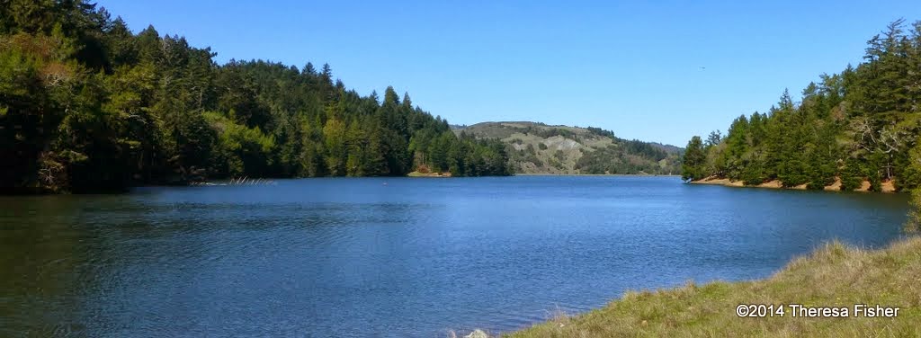
This is a lovely, level lakeside loop! We could see Ring-necked Ducks, Common Mergansers, American Widgeons, Ruddy Ducks, Buffleheads, and more. This could also be the week for our first Acmon Blue butterfly!

(Click here for a recap of our 2010 hike. There's also an album of photos taken on past hikes.)

Remember to bring your contribution to our gourmet feast, a plate, cup, and utensils.  (We'll have lunch at Wendy's home in San Anselmo if rain makes it impossible to use the group picnic area at Lake Lagunitas.)

Directions to trailhead: Take Sir Francis Drake Boulevard into Fairfax. Jog left and make an immediate right in front of the movie theater.

The first left puts you on Bolinas Avenue. Follow this until you see the sign on your left for Lake Bon Tempe and Lake Lagunitas.

Click here for the MMWD map and directions. Or click here for a Google Maps map showing the trailhead location; click on the teardrop icon to get driving directions and estimated travel time from your location.

Unless you have an MMWD pass, continue past the old toll booth, pull over at the parking area on the right and pay the day use fee, and then continue driving until you reach the end of the road.
 
The day use fee is $8.  You can use a credit card, $1, $5, or $10 bills (but not coins or $20 bills) at the automated pay station.

Annual watershed area parking passes for Marin residents are $60 ($30 for those 62 and older). You can buy them online or at the MMWD main office in Corte Madera.

Time: 30 minutes from College of Marin. Outhouse in parking lot; portables en route

Carpoolers can meet at St. Rita's Church at 9:20 a.m. Click here for a Google Maps map showing St. Rita's ("A") and directions and estimated driving time to the trailhead.

We’ll have lunch at the picnic area at Lake Lagunitas so you don’t need to carry the food for the potluck.

Weather forecast:  As of Tuesday, March 14th, the National Weather Service forecast for the hike was a chance of rain. Partly sunny, with a high near 63 (Click here for an updated forecast).

More on this hike: Hike "C13 Bon Tempe Lake Trail" in the Martins' book, Hiking Marin, shows the general area where we will be hiking. However, we'll start and end at trail junction #2 on their map, rather than at Bon Tempe dam. (Click here for an MMWD map that shows this area).


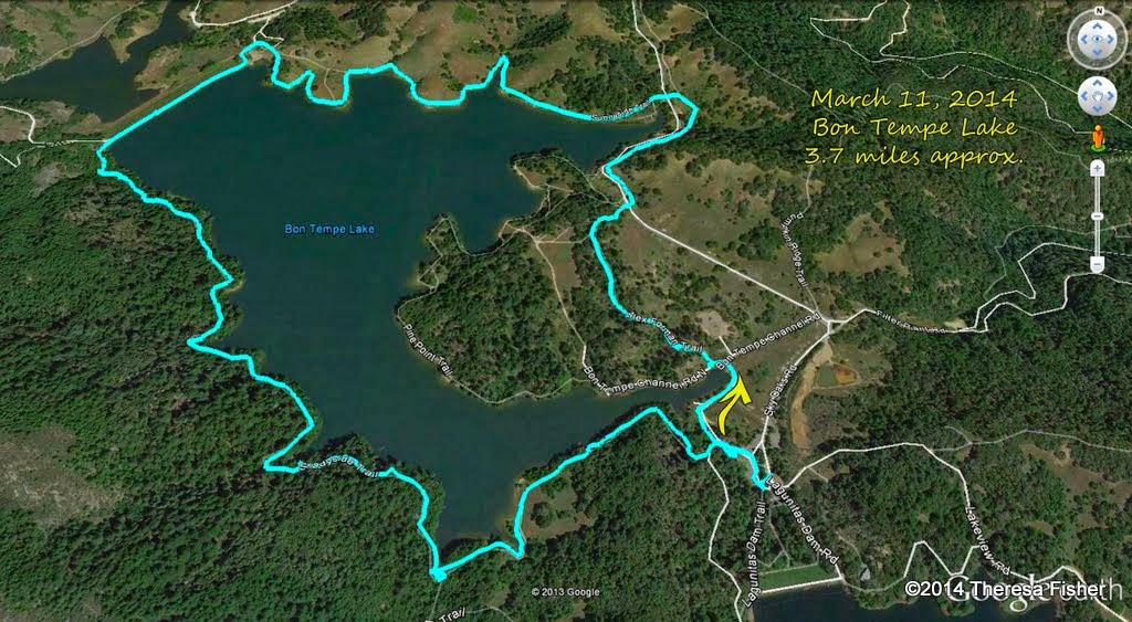
This hike is a little shorter than average at about 3.7 miles, without a great deal of elevation change.


The Google Earth image below shows both lakes in a view looking back towards Fairfax. (Click on the photo to open a larger image in your Web browser).

Wednesday, March 8, 2017

Deer Park to Phoenix Lake Hike (3/14) Preview

THIS HIKE WAS ORIGINALLY TO TAKE PLACE ON MARCH 7TH BUT HAS BEEN RESCHEDULED TO MARCH 14TH.

This is a scenic hike with lunch at Phoenix Lake.  We should see Red Larkspur, Gypsum Spring Beauty, Baby Blue Eyes, and Ground Iris  Maybe we'll hear the first Orange-Crowned Warblers of the season singing their spring song!  (Click here for a recap of our hike in March 2010 or here for photos from past hikes.)

Directions to trailhead:  Go west on Sir Francis Drake Boulevard to Fairfax. As you enter Fairfax, turn left at the gas station, and make an immediate right in front of the movie theater. This puts you on Broadway.

Make the first left onto Bolinas Avenue. Just after it veers left, turn left on Porteous Avenue. Follow it to the parking lot at Deer Park.

(Click here for a Google Maps map showing the location of Deer Park. Click on the teardrop icon to get driving directions and estimated driving time from your location.)

15 minutes from College of Marin. Carpoolers can meet at St. Rita's Church at 9:30 a.m.

Restrooms at trailhead.

Weather forecast:  As of Wednesday, March 8th, the National Weather Service forecast for the hike was partly sunny, with a high near 67. (Click here for an updated forecast).

More on this hike: Presumably we'll follow the same route as in the past. The Martin's Hiking in Marin trail guide does not have a single map and directions for our hike from Deer Park School to Phoenix Lake and back, but you can use the following two maps and hikes from their book to piece together our path:

Start off using the Martin's Hike "C6 - Deer Park Road - Yolanda Trail." Head up the Deer Park Fire Road to Oak Tree Junction, then turn left (to the south) and hike uphill on the Six Points Trail. When you reach the Six Points junction, switch to Hike "C4 - Hidden Meadow - Yolanda Trail" and hike down the Yolanda South Trail to Phoenix Lake.

Using that same hike and map, follow Shaver Grade uphill, and while doing so, refer back to the C6 hike and map to follow the Grade to Five Corners. Continue straight down Deer Park Fire Road to Boy Scout Junction. Cross the fire road and take the Junction Trail back to its intersection with Deer Park Fire Road (just where you turned off onto Six Points Trail when you were headed toward the lake).

Here's a Google Earth view looking from Deer Park over Bald Hill towards Phoenix Lake.

Here's the hike's profile.

Saturday, March 4, 2017

Audubon Canyon Hike (3/7) Preview

THIS HIKE WAS SUPPOSED TO TAKE PLACE ON FEB. 7TH, BUT WAS RAINED OUT AND RESCHEDULED FOR MARCH 7TH.

DEER PARK TO PHOENIX LAKE, ORIGINALLY SET FOR MARCH 7TH WILL TAKE PLACE MARCH 14TH. THE "FINAL EXAM" HIKE HAS BEEN PUSHED BACK A WEEK TO MARCH 21ST.

Lucky us!  We have permission to hike in Audubon Canyon Ranch Bolinas Lagoon Preserve! This is beautiful habitat, not usually open to the public.

(Click here for a recap of our 2011 hike. View photos from our past hikes at Audubon Canyon ranch in this online album).

Directions to trailhead:  

Coming from North or Central Marin: Take Sir Francis Drake Boulevard to Olema. Turn south (left) on Highway 1 and continue on for about 10 miles to Bolinas Lagoon. The preserve will be on the left approximately 1 mile further south. 

Carpoolers can meet at St. Rita's Church in Fairfax at 8:45 am.

Coming from Southern Marin:
From Highway 101 take the Stinson Beach exit. Follow the signs and Highway 1 approximately 12 miles to Stinson Beach. Continue 3 1/2 miles north to the preserve gate on right hand side of the highway.

Click here for a Google Maps map that shows the location of Audubon Canyon Ranch. Click on the teardrop icon to get driving times and directions from your location.

Time: 1 hour from College of Marin. Restrooms at trailhead.

Weather forecast: As of Saturday, March 4th, the National Weather Service forecast for the hike was partly sunny, with a high near 57. (Click here for an updated forecast).

More on this hike: If you have the Martins' book, Hiking Marin, go to hike "F18 Griffin Loop - Bird Overlook Trails" for a map of trails within the preserve.

There are two major loop trails (probably about 3 miles long each) going uphill and down, and a shorter 0.8 mile loop nearer to the bottom of the hill.

On our 2009 hike we went up the Zumie's Loop Trail, then through Junction 2 on the Martin's map, and continued south to where the Griffin Loop and Bourne trails meet, descended the Griffin Loop trail to the bottom of the hill, and then looped back to the parking area.