Wednesday, December 5, 2018

Winter 2019 Hiking Schedule and Registration on Jan 3 at 9 a.m.

Register on January 3rd at 9 a.m. for Winter 2019 Meandering in Marin with Wendy Dreskin.

3698 | Dreskin |OFF| TBA
8 Tuesdays 9:45am–1:45pm | Jan 29-Mar 19
$183 (FF TBD) |ESCOM$156 (FF TBD)

Wendy says: Sorry, they are still in the process of bargaining about State Park fees.  That's why it says TBD.   We're hoping for $2/state park hike but it could be more. 


Here is the hiking schedule:

January 29  BOOTJACK, MOUNT TAMALPAIS
     A mostly shady trail opens up to an incredible vista at a sunny (we hope!) lunch spot overlooking the ocean!   We’ll take Bootjack trail to Van Wyk Meadow, TCC trail to the Dipsea trail, and Old Mine back.  About 700’ change in elevation round trip.
      Take the Stinson Beach/Hway 1 exit off Hway 101. Go west through Tam Valley and up onto the ridge. Turn right onto Panoramic Hway and follow signs to Mt. Tamalpais.
        Time:  50 minutes from College of Marin. Restrooms at trailhead.  Fee parking area, $8 regular, $7 seniors. Bring exact change.)   

February 5  CARSON FALLS, MMWD WATERSHED
     This hike takes us through chaparral to the beautiful falls on Pine Mountain where we’ll have lunch. 
     As you enter Fairfax on Sir Francis Drake Boulevard jog left on Pacheco when you see the movie theater and make an immediate right.  This puts you on Broadway, the street that parallels Sir Francis Drake but is on the other side of the parkade. Make the first left which is Bolinas Ave. Follow the Bolinas-Fairfax Road for about 4 miles to a dirt parking lot on your left.
(300’ up, 400’ down each way on this out-and-back hike. Loose rocks on Pine Mt Fire Rd so you might want poles.)


February 12  SKY OAKS, MMWD       
     This loop starts out in oak/bay/madrone habitat, but we'll also see redwoods and some grassland.  This is a good mushroom hike with Boletes, Amanitas, Waxy Caps, Milky Caps.
       Take Sir Francis Drake Blvd. into Fairfax.  Turn left on Pacheco and make an immediate right in front of the movie theater which puts you on Broadway.  The first left puts you on Bolinas Ave.  Follow this until you see the sign on your left for Lake Bon Tempe and Lake Lagunitas. Follow the road to the tollbooth by Sky Oaks Ranger Station.  (Credit card accepted by the machine.)
      Time: 25 minutes from College of Marin. 


February  19  AUDUBON CANYON RANCH
     Lucky us!  We have permission to hike in Audubon Canyon Ranch!  This is beautiful habitat, not usually open to the public. About 1100' elevation gain. 
     Take Sir Francis Drake Blvd. to Olema. Turn south (left) on Highway 1 and follow for about 10 miles to Bolinas Lagoon. Preserve will be on the left approximately 1 mile further. The entrance will be closed with a gate.  Go south of the entrance and go in the exit.  Or from Highway 101  take the Stinson Beach exit. Follow approximately 12 miles to Stinson Beach. Continue 3 1/2 miles north to the parking lot exit just before the preserve gate on right hand side of the highway. If you don't know where it is, you may have to drive to the official entrance and turn around.
      Time: 1 hour from College of Marin.  Restrooms at trailhead.


February 26  BLITHEDALE CANYON LOOP. MILL VALLEY
     A loop with great views of Mt. Tamalpais!  Early wildflowers and probably a 9 fern day!  My favorite Star Lily patch in all Marin!
     Take East Blithedale exit from 101. Where you cross Throckmorton it becomes West Blithedale. Go .9 miles and look for parking at Marsh and West Blithedale on both the left and the right sides of the street.
     Time: 30 minutes from COM.  No restrooms at trailhead. (Uphill, followed by long level stretch. About 350’ elevation gain. If you like poles where the trail has a steep drop on one side, bring them for sections of Hoo-koo-e-koo.)


March 5  STEEP RAVINE –DIPSEA  
     On this favorite early spring hike we should see Giant Wake Robin, Redwood
Evergreen Violets, Star Lilies, Smith’s Fairy Bells, Fetid Adder’s Tongue and Calypso Orchids! We’ll go up Steep Ravine since some of us find the ladder is easier to go up than down.  Lunch (and restrooms) at Pantoll.  (If you sometimes use poles, this hike is one where you’ll want them. Lots of stairs on the downhill. 1100’ up and 1100’ back down.)
If you are heading south on Highway 1, simply continue south on Highway 1 through Stinson Beach.  The gated road to Steep Ravine cabins will be on your right. Some parking on both sides of the road.  Time: 1 hour 5 minutes from COM.  No restrooms at trailhead.
From southern Marin, take the Stinson Beach/Hway 1 exit off Hway 101. Go through Tam Junction, stay on Rt. 1 and follow signs to Muir Beach. Pass the road that goes to Muir Beach staying on Rt.1 (towards Stinson Beach), pass Slide Ranch, and keep going until you see the locked gate for the Steep Ravine cabins on the west side of the road.  There is some parking is on both sides of the road.


March 12  DEER PARK TO LAKE PHOENIX
     This is a scenic hike with lunch at Phoenix Lake. We should see Red Larkspur, Gypsum Spring Beauty, Baby Blue Eyes, and Ground Iris.  Maybe we'll hear the first  Orange-Crowned Warblers of the season singing their spring song!
(200’ up, 300’ down each direction.)
     Go west on Sir Francis Drake Blvd. to Fairfax.  As you enter Fairfax, turn left on Pachco at the gas station, and make an immediate right in front of the movie theater.  This puts you on Broadway.  Make the first left onto Bolinas Ave.  Just after it veers left, turn left on Porteous Ave.  Follow it to the parking lot at Deer Park. 
     15 minutes from College of Marin.  Restrooms at trailhead.


March 19  FINAL EXAM  BON TEMPE AND LAGUNITAS LAKES
        This is a lovely, level lakeside loop!  We could see Ring-necked ducks, Common Mergansers, American Wigeons, Ruddy ducks, Buffleheads, and more.  This could also be the week for our first Acmon blue butterfly!
       Remember to bring your contribution to our gourmet feast, a plate, cup, and utensils.
       As you enter Fairfax on Sir Francis Drake Blvd. jog left on Pacheco when you see the movie theater and make an immediate right.  This puts you on the street that parallels SF Drake but is on the other side of the parkade. Make the first left which is Bolinas Ave. Follow the Bolinas-Fairfax Rd. for about 1 mile. Turn left onto Sky Oaks Rd. Pass the kiosk and pull in to the parking area on the right where you pay. Follow the paved road on to Lake Lagunitas. We’ll have lunch at the picnic area at Lake Lagunitas so you don’t need to carry the food for the potluck.
             Time: 30 minutes from College of Marin. Portables at trailhead and en route.


Until the Winter College of Marin series of hikes begin, Wendy will be running a series of by-the-week one-way shuttle hikes. UNLIKE CLASSES THROUGH COM, RAIN CANCELS!   

Wendy says: "Please email or call to let me know if you will be there since these are shuttle hikes, and also so I can let you know if there is a rain cancellation.  In case of questionable weather, look for an email at 7:15 a.m."

Here are the dates for both Monday and Tuesday hikes:

  • Tuesday December 11 - Alpine Dam to Bon Tempe Dam 
  • Monday January 7- Sky Oaks to Deer Park
  • Tuesday January 8 - Sky Trail to Bear Valley
  • Monday January 14 -Pine Mountain/Elliott Preserve
  • Tuesday January 15 - Sky Oaks to Deer Park 
  • Monday January 21 - Sky Trail to Bear Valley
  • Tuesday January 23 - Pine Mountain/Elliott Preserve 
  • Details follow.

  • DECEMBER  11  ALPINE DAM TO BON TEMPE DAM
        
    We hike along a creek with lovely cascades and ferns.  This is usually an interesting mushroom hike as well. The start is uphill with many stairs (but we’ll find lots to look at on the way), the end is level - and in between it’s up and down!  We end up at the Bon Tempe Dam.  NOTE: This hike often takes us more than 4 hours. We could get back as late as 3 PM.
              Go west on Sir Francis Drake Blvd. to Fairfax.  As you enter Fairfax, turn left on Pacheco (at the gas station), and make an immediate right in front of the movie theater.  This puts you on Broadway.  Make the first left onto Bolinas Ave which becomes the Fairfax-Bolinas Road.  Go approximately 1½ miles.  At 700 Bolinas Road there is a wooden sign on your left saying “Lake Lagunitas.” Turn left at the sign, onto Sky Oaks Road.  After the ranger station at Sky Oaks (but before Shaver Grade) there is an unpaved road to the right. Take this to the parking lot below the Lake Bon Tempe Dam. MEET AT 9:15. We’ll carpool to the trailhead. Do not pay at the Sky Oaks toll station if you plan to take people to the trailhead.  We’ll need people who are not in a rush to take the drivers back to their cars.
          
    Portables are in the parking lot for Lake Bon Tempe.

    MONDAY, JANUARY 7  SKY OAKS TO DEER PARK 

                Mostly downhill and level!  Mushrooms and early wildflowers!
                Meet at Deer Park to carpool.  Take Bolinas Ave in Fairfax, turn left on Porteous. (If you see Deer Park Villa you’ve gone a bit too far, turn around.) Go to the parking lot at the end.
         Restrooms at Deer Park and portable at Sky Oaks and en route.  20 minutes from College of Marin.  

    TUESDAY, JANUARY 8  SKY TRAIL TO BEAR VALLEY
         
    This is a lovely trail any time of year, and especially in the “green” season! Think mushrooms!
    We’ll meet at Bear Valley and carpool to Sky Trail.  When we get to Mt. Wittenberg we’ll go down Old Pine. We’ll need some people who are not in a rush to drive people back to Sky Trail Trailhead. NOTE:  Part of this trail can get really wet/puddly if it has rained recently so use appropriate footgear.
             Take Sir Francis Drake Blvd. west to Olema.  Turn right on Rt.1, then make an immediate left onto Bear Valley Rd.  Head west about 1/2 mile. Look for a big red barn on the left and a sign for "Visitor Center; Headquarters; Information."  Turn left. Park in the lot on your left.  (Not the lot closest to the Visitor’s Center.)  Restrooms at Bear Valley, none at Sky Trail trailhead.  Outhouses at Coast Camp.

    MONDAY, JANUARY 14   PINE MOUNTAIN/ELLIOTT NATURE PRESERVE
         
    This hike starts in chaparral and passes by serpentine areas.  We go through the pygmy Sargent cypress forest, and return through oak/bay/madrone woodland. We'll check out birds and mushrooms as we go.  Maybe the first Shooting Stars of spring!
         We need people to meet at the end of Cascade Dr.in Fairfax  at 9:20. (If you have time pressure after class go there as well, since the car shuttle won’t get us back until a little after 2 PM.)  I will drive those drivers to the start of the hike. Others, meet at the trailhead.  Take the Bolinas-Fairfax Road approximately 4 miles. You past the Meadow Club (golf course) and keep going. Park across from the Pine Mountain Fire Rd.  It is a large dirt parking lot on your left, and the fire road is on the right. If you start going downhill and can see Lake Alpine, you’ve gone too far.

    TUESDAY, JANUARY 15   SKY OAKS TO DEER PARK

                Mostly downhill and level!  Mushrooms and early wildflowers!
                Meet at Deer Park to carpool.  Take Bolinas Ave in Fairfax, turn left on Porteous. (If you see Deer Park Villa you’ve gone a bit too far, turn around.) Go to the parking lot at the end.
         Restrooms at Deer Park and portable at Sky Oaks and en route.  20 minutes from College of Marin.  

    MONDAY, JANUARY 21   SKY TRAIL TO BEAR VALLEY
         
    This is a lovely trail any time of year, and especially in the “green” season! Think mushrooms and early wildflowers!
         We’ll meet at Bear Valley and carpool to Sky Trail.  When we get to Mt. Wittenberg we’ll go down Old Pine. We’ll need some people who are not in a rush to drive people back to Sky Trail. NOTE:  This trail can get really wet/puddly if it has rained recently so use appropriate footgear.
              Take Sir Francis Drake Blvd. west to Olema.  Turn right on Rt.1, then make an immediate left onto Bear Valley Rd.  Head west about 1/2 mile. Look for a big red barn on the left and a sign for "Visitor Center; Headquarters; Information."  Turn left. Park in the lot on your left.  (Not the lot closest to the Visitor’s Center.)  Restrooms at Bear Valley, none at Sky Trail trailhead.  Outhouses at Coast Camp.

    TUESDAY, JANUARY 22    PINE MOUNTAIN/ELLIOTT NATURE PRESERVE
               
    This hike starts in chaparral and passes by serpentine areas.  We go through the pygmy Sargent cypress forest, and return through oak/bay/madrone woodland. We'll check out birds and mushrooms as we go.  Maybe the first Shooting Stars of spring!
         We need people to meet at the end of Cascade Dr.in Fairfax  at 9:20. If you have time pressure after class go there as well, since the car shuttle won’t get us back until a little after 2PM.  I will drive those drivers to the start of the hike. Others, meet at the trailhead.  Take the Bolinas-Fairfax Road approximately 4 miles. You past the Meadow Club (golf course) and keep going. Park across from the Pine Mountain Fire Rd.  It is a large dirt parking lot on your left, and the fire road is on the right. If you start going downhill and can see Lake Alpine, you’ve gone too far.
  • Thursday, November 29, 2018

    Lake Lagunitas MMWD 12/4/18

    We return to the MMWD watershed for our final hike of the 2018 Fall "2" session.

    Here's what Wendy says we'll be doing:  "We make a partial circle around the lake, looking for Ring-Neck ducks, Mergansers, Grebes and other birds, and then make a loop past Pilot Knob, returning on Southern Marin Line. We usually see newts and some interesting mushrooms on this hike."

    "Bring your contribution to our gourmet feast, plus a plate, utensils, and a cup." (Click here for a recap of our December 2009 "Final Exam" hike at this location or click here for photos from past hikes.)

    Directions to trailhead: Take Sir Francis Drake Boulevard into Fairfax. Turn left on Pacheco and make an immediate right in front of the movie theater onto Broadway. The first left puts you on Bolinas Avenue. Follow this until you see the sign on your left for Lake Bon Tempe and Lake Lagunitas, Sky Oaks Rd. Follow the road to the old toll booth by Sky Oaks Ranger Station.

    Click here for the MMWD map and directions. Or click here for a Google Maps map showing the trailhead location; click on the teardrop icon to get driving directions and estimated travel time from your location.

    Unless you have an MMWD pass, continue past the old toll booth, pull over at the parking area on the right and pay the day use fee, and then continue driving until you reach the end of the road.

    The day use fee is $8.  You can use a credit card, $1, $5, or $10 bills (but not coins or $20 bills) at the automated pay station which will not give you change back if you overpay.

    Annual watershed area parking passes for Marin residents are $60 ($30 for those 62 and older). You can buy them online or at the MMWD main office in Corte Madera.

    Time: 30 minutes from College of Marin. Outhouse in parking lot.


    Weather forecast:  As of Thursday November 29th, the National Weather Service forecast for the hike was a chance of showers. Partly sunny with a high near 53.  (Click here for an updated National Weather service forecast.)

    More on this hike:  Hike "C16 - Lakeview FR to Pilot Knob" in the Martin's book, Hiking Marin, sets out a shorter hike than we'll be doing; instead of following the Pilot Knob trail back to the parking lot, we'll take a longer route back by continuing eastward and then looping back the west, picking up the Southern Marin Line Road (called the Filter Plant Road on the Martin's map). (Click here to view, zoom in on, and print a map of the MMWD watershed lands).

    Here's the route we'll follow.


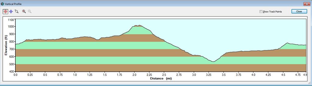
    Here's the hike profile.

    Thursday, November 22, 2018

    Dipsea to Ben Johnson/Muir Woods 11/27/18

    Having It Both Ways On the Hillside TrailThis week we head south in the County and back into the federal park lands.  Here's Wendy's description of the hike: "Instead of racing up the Dipsea, we’ll stop to admire ancient redwoods, beautiful views, and hopefully early mushrooms."  (Click here to read the recap of our 2/10/09 hike on these trails. You can view photos taken on previous hikes.)

    Directions to trailhead: From Highway 101 take the Stinson Beach exit, turn left (west) onto Shoreline Highway (Highway 1). At the junction with Loring Avenue, turn left again to continue on Shoreline Highway instead of heading into Mill Valley.

    Turn right onto Panoramic Highway and left onto Muir Woods Road. Meet at Muir Woods Parking Lot #2 (overflow parking).

    Click here for a Google Maps map that shows the location of the parking lot. Click on teardrop icon to get driving directions and time from your location.

    Time: 35 minutes from College of Marin. Restrooms at trailhead.

    Carpoolers can meet at the Greenbrae Parking & Ride lot at 9:00 a.m. (Click here for a Google Maps map showing the parking lot on Drakes Landing Road; click on the teardrop icon to get driving time and directions from your location.)

    Weather forecast: As of Wednesday, November 30th, the National Weather Service forecast for the hike was a chance of rain. Cloudy with a high near 62. (Click here for an updated forecast).

    More on this hike: We'll hike up the Dipsea Trail, then descend back to the floor of Muir Woods on the Ben Johnson Trail. (Click here to view and download the park trail map).

    If you have Tracy Salcedo-Chourre's book, Exploring Point Reyes National Seashore and Golden Gate National Recreation Area, you'll see that she proposes hiking this route in the reverse direction (up the Ben Johnson, down the Dipsea) from our plan, but her book will at least give you an idea of what our hike will be like.

    This Google Earth image shows our route and distance.

    Here's the hike's elevation profile.