Wednesday, March 30, 2011

Mount Burdell Open Space (4/5) Hike Preview

This week we return again to the Novato area go hiking.  Last week it was in the open space above Indian Valley College.  This week we hike on Mount Burdell. Here's Wendy's description of the hike: " This loop takes us by Hidden Lake which is home to thousands of Pacific tree frogs! We may see cream cups, tidy tips, baby stars, and balloon clover,  as well as seven or eight species of butterflies. This is the only spot where bitterroot, the Montana state flower, grows in Marin."

Directions to the trailhead: Take Highway 101 north and take the San Marin Drive exit. Go west on San Marin Drive. Turn right on San Andreas Drive. The entrance to the Open Space will be on your right. If you come to the dead end of San Andreas you've only gone about half a block too far. No lot but plenty of curbside parking. 30 minutes from College of Marin. No restrooms on this hike. (Carpoolers can meet at the Mission Street, San Rafael, Park & Ride lot around 9:05 am, or at the Smith Ranch Park & Ride lot around 9:15 am).

Weather forecast: As of Wednesday, March 30, the National Weather Service forecast for the day of the hike was mostly sunny, with a high near 69.(Click here for an updated forecast).

More on this hike: Hike "E13 Old Quarry Trail to Mt. Burdell" in the Martin's book, Hiking Marin, shows the general area that we'll be hiking in, although we'll probably turn left at intersection #2 and head directly to Hidden Lake rather than climb all of the way to the summit of the mountain as shown on the Martin's map. You can find a preserve map on the Marin County Open Space District's Web site for the Mount Burdell preserve. The Google Earth image below shows where we'll be hiking. (Click on the photo to open a larger image in your Web browser).

Tuesday, March 22, 2011

Indian Valley Open Space Hike (3/29) Preview

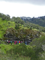
Two loops combine to make an interesting hike.  Tomcat clover, fiddleneck, and Plectritis should be in bloom this week, and if we haven't heard the first Pacific Slope flycatcher yet, we often here it at IVC.

(Click here for a recap of last year's hike).

Directions to trailhead: Take Highway 101 to the Ignacio Boulevard exit. Go west and follow Ignacio Boulevard into the Indian Valley College campus. Our hike starts from parking lot #7 by the athletic field. (Click here for to view and print a map of the campus). Bring a dozen quarters to get a ticket from the parking machines ($3/day ). 25 minutes from College of Marin. Restrooms at trailhead. (Carpoolers can meet at Smith Ranch Park & Ride lot around 9:15-20 am).

Weather forecast: As of Tuesday evening, March 22, the National Weather Service forecast for the hike was partly sunny with a high near 62. (Click here for an updated forecast).

More on this hike: Two hikes in the Martin's book, Hiking Marin, cover the area that we'll traverse: "E6 Indian Valley FR - Waterfall Trail" and "E7 Schwindt - Wildcat Trails". You can also view and print the map and species list for the Marin County Open Space District's Indian Valley preserve. (For another hike description and more photos of the IVC Open Space, check out this page on the "Bay Area Hiker" Web site). The Google Earth photo below shows this area. (Click on the photo to open a larger image in your Web browser).


Monday, March 21, 2011

Colorful Places to Welcome Spring in San Francisco

Even though we don't get extremely harsh winters in San Francisco, spring is still welcomed with a sigh of relief. Gardens that were green through the past few months introduce a fiesta of colorful flowers just in time for the lengthening days.

Embrace Mother Nature's abundance at these spots where spring is center stage. San Francisco Botanical Gar ..read more.. 

Sunday, March 20, 2011

Bon Tempe to Lagunitas "Final Exam" Hike Photos Now On-Line!

Photos taken by Theresa Fisher during last week's Bon Tempe to Lake Lagunitas "Final Exam" hike are now on-line. 

You can view them on the Meandering blog or click here for the on-line photo album.

(Click here for video clips Dick Jordan shot at luncheon held indoors at Wendy's home).

Photos of the Dedication of Silvia Lange's Bench on Angel Island

A few hardy souls braved the inclement weather on Sunday to hike up Mount Livermore on Angel Island for the dedication of a bench to the memory of Silvia Lange. 

Here's how Wendy described the event: "The hike up was quite an adventure as trees blocked the trail in many places and we had to bushwack and sometimes literally crawl to get around them."

(Click here for a few photos of the dedication).

Thursday, March 17, 2011

Oakland Mountain View Cemetery Honors the Memory of Silvia Lange

Here's additional information on the Saturday, March 19 dedication of a cenotaph to the memory of Siliva Lange which will take place at Oakland's Mountain View Cemetery:

"Bring umbrellas and we will meet at the office at 1:00 PM and drive up to the top of Plot 71, Lot 43.  Afterwards we will return to  the board room for refreshments kindly arranged by Doreen.  Let’s give our Silvia  a memorable send-off.

I understand that the following will be there: Doreen, Barbara Smith, Ron Bachman, Michael Colbruno, Barbara Gibson, Joyce Temby, Silvia ‘s niece Karen, and nephews John and Robert and their wives, Wendy and Bill Dreskin, Karin Thoreson, Stan Walker, Sharon Bozic, plus three from Angel Island.  Any others planning to join us?

For more info contact:"
Doreen Herbruger
Customer Service Manager
Mountain View Cemetery
(510) 658-2588 - phone
(510) 652-2726 - fax

Wednesday, March 16, 2011

Dedication of Silvia Lange's Bench on Angel Island (Sunday, March 20)

On Sunday, March 20, a bench on Angel Island State Park will be dedicated to the memory of Angel Island docent and Tuesday Meanderer, Silvia Lange.  (Click here for more information on this event, and another memorial event at Oakland's Mountain View Cemetery on Saturday, March 19).

Here's the latest from Wendy on Sunday's event:

"Please take the 10 AM ferry. Gloria and some musician friends have volunteered to sing Silvia songs between the arrival of the 10 AM ferry from Tiburon and the arrival of the SF ferry. Please bring some drinks to share along with the desserts. Plates, napkins, etc will be provided. Thank you all!"

(Dick Jordan will be in Los Angeles and miss both events.  If you go, please send him photos you take and your re-cap, and he'll post that information on the Meandering blog.)

Reminder - No Hike on Tuesday, March 22nd

Just a reminder from the Meandering in Marin Blog that there will be no hike on Tuesday, March 22nd.

The next hike will be on at Indian Valley College Open Space on Tuesday, March 29th, when we kick off the Spring 2011 College of Marin term.

Tuesday, March 15, 2011

Meandering Final Exam YouTube Flicks!

The rain moved the Winter "Final Exam" luncheon indoors for the first time in at least three years, but didn't dampened the appetites of the Meanderers.  (Click here to view a short YouTube video clip of the lunch).

Debbie, who has been busy raising her new puppy, came to the event with her pooch.  (Click here for a video clip of the hit of the party).

Over The Hill (And Back Again)

Why does it always seem to rain at just this one spot on the Yolanda Trail?  (Click here if you can see the YouTube video in this post).

After managing to dodge the car-eating potholes where Porteous Avenue enters the former Deer Park School property, we gathered up our gear, and set off under gray skies across the grounds of the old school and west by southwest on the Deer Park Fire Road.  Some of us got a quick peek at an elusive, Double-Shot-of-Espresso Ruby Crowned Kinglet, a bird who never wants to sit still long enough to let you find it in your binoculars.

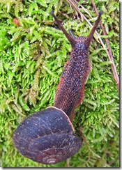
Moving At A Snail's Pace Milk Maids, Shooting Stars, and Houndstongue bloomed along this section of our route.  Dock beetles chomped on leaves, and a banana slug (who must have slept in) breakfasted as we walked by.  Within about a half hour we had turned south onto the Six Points Trail, making our way, snail-like, up the narrow path that leads to the Six Points Junction.  A Scarlet Waxy Cap and Orange Mock Oyster mushrooms told us that we were still hiking in winter.  But the stream that parallels the trail was just gurgling downhill, not rushing past us in the other direction as it would have if it had rained heavily the day before.

At Six Points we stopped to doff some layers of clothing, take a brief rest break, and quaff some water before heading down the Yolanda Trail towards Phoenix Lake.  Not long after we resumed the hike we found a field with Red Stemmed Storksbills.

For some reason—perhaps because the clouds cool as they are lifted up over Bald Hill—rain showers always seem to fall when we hike the Yolanda Trail.  So we quickly donned our jackets to ward off the five-minute bout of precipitation.  The top of Mt. Tam remained shrouded in mist.

Red Scarlett Larkspur and Lupine (some with beetles crawling about on their flowers) lined the trail.  Neil stopped to check out the rocky outcroppings, practicing his new-found skills as a geologist.
 
By noon we had reached the lake and had lunch just below the manager’s house of the old Porteous Ranch.  A Red-Tailed Hawk eyed our eats from atop a nearby tree, but after determining that we weren’t packing rodent-meat sandwiches, left us to enjoy our meal in peace.

It look us about 45 minutes to ascend the Shaver Grade to Five Corners; if the hairy caterpillar we saw along the way had followed us, he probably would have arrived 45 days later.  From there it was a 10 minute downhill saunter to Boy Scout Junction where a couple of us decided to go down the Deer Park Fire Road and the rest set off on the Junction Trail.

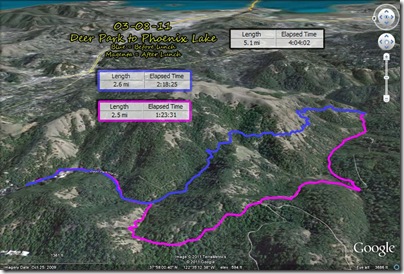
x-GoogleEarth3D-WithStats-FacingEast  
At just about our usual “quitting time” we were back at the parking lot.  We’d hiked 5.1 miles, twice gaining (and losing) about 400’ in elevation.

x-VerticalProfile

Monday, March 14, 2011

Deer Park to Phoenix Lake Hike Photos Now On-Line!

Photos shot by Theresa Fisher, Al Grumet, and Dick Jordan during last week's Deer Park to Phoenix Lake hike are now on-line.

View them on the Meandering blog or click here for the on-line photo album.

Friday, March 11, 2011

Marin Tsunami Warning Issued Following Japan Earthquake

Tsunami Warning for the Marin Coastline (issued by the San Anselmo Police Department on Friday March 11, 2011 9:57 AM PST)

Due to the 8.9 magnitude earthquake in Japan, A Tsunami Warning has been issued for the California coastline. The Marin coastline will experience strong and dangerous currents and some flooding is possible. The public is advised to stay off the beaches, out of the water and secure personal watercrafts between 7:30am and 8pm today.

Tidal surge inside the Bay is not expected to be as significant as at the coastline, however boaters and the public should stay inland and off the bay waters during this time.

Marin County public safety agencies are coordinating information and public notifications. The public is advised to call 2-1-1 for updated information. Mandatory evacuations are not in affect. Tsunami waves are estimated to reach 1 to 1.5 feet (above normal sea conditions).

The Golden Gate National Recreation Area parking lots are closed at Muir Beach and Stinson Beach. Persons in the inner bay should move off the beach and out of harbors and marinas. Persons in coastal Tsunami inundation zones should move inland and to higher ground. Marin County inundation zones include areas of Muir Beach, Stinson Beach, Marshall and Bolinas.

A Tsunami Warning means that a tsunami with significant widespread inundation is imminent or expected. Warnings indicate that widespread dangerous coastal flooding accompanied by powerful currents is possible and may continue for several hours after the initial wave. Currents may be hazardous to swimmers, boats, and coastal structures.

Please visit the County’s Office of Emergency Services website at www.readymarin.org (click on “Current Emergency Information”) for updates on Tsunami information.

For full details, go to https://local.nixle.com/alert/4665186/?sub_id=259802

Thursday, March 10, 2011

Where There's Geography, There's Hope

The 2011 Geography of Hope Conference celebrates “Reflections on Water” with literary conversations, art, and field trips to farms, wetlands, and wilderness areas in the West Marin countryside. It will take place from Friday, March 18 through Sunday, March 20, at Point Reyes Station.  Click here to go to the Conference Website where you can obtain complete details and register on-line.

The Conference is co-chaired by award-winning poet Brenda Hillman and former United States Poet Laureate Robert Hass who bring a wealth of literary inspiration and personal magnetism to the event. It also features other established and emerging writers including Michael Ondaatje, William Least Heat-Moon, Tom Farber, Eddy L. Harris, Julia Whitty, Peter Gleick, Philip Fradkin, Alex Fradkin, Tim Palmer, Linda Spalding, Pamela Michael, Claire Peaslee, eco-poets Evelyn Reilly and Jonathan Skinner, and Heyday Books publisher Malcolm Margolin.

Bon Tempe & Lagunitas Lakes "Final Exam" Hike (3/15) Preview

This is a lovely, level lakeside loop! We could see ring-necked ducks, common mergansers, American widgeons, ruddy ducks, buffleheads, and more.  This could also be the week for our first Acmon blue butterly!
Remember to bring your contribution to our gourmet feast, a plate, cup, and utensils.  (Click here for a recap of last year's hike).

Directions to trailhead:  As you enter Fairfax on Sir Francis Drake Boulevard jog left when you see the movie theater and make an immediate right. This puts you on the street that parallels Sir Francis Drake, but is on the other side of the Parkade.

Make the first left which is Bolinas Avenue. Follow the Bolinas-Fairfax Road for about 1 mile. Turn left onto Sky Oaks Road. You’ll need to pay at the kiosk ($8/day; or purchase a pass for $60 for Marin residents, $30 for Marin seniors 62 and older, good through next January; pay with $1, $5 and $10 bills or Visa or Mastercard.  $20 bills are NOT accepted by the pay station.

Follow the paved road on to Lake Lagunitas. We’ll have lunch at the picnic area at Lake Lagunitas so you don’t need to carry the food for the potluck.

Time: 30 minutes from College of Marin. Restrooms at trailhead, portables en route. Carpoolers can meet at St. Rita's Church at 9:20 am.

Weather forecast:  As of Thursday, March 10, the National Weather Service forecast for the hike was mostly cloudy with a high near 60 and a slight chance of rain. (Click here for an updated forecast).

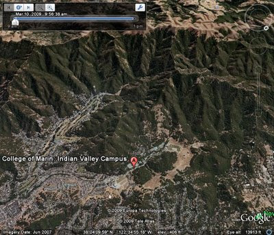
More on this hike: Hike "C13 Bon Tempe Lake Trail" in the Martins' book, Hiking Marin, shows the general area where we will be hiking. However, we'll start and end at trail junction #2 on their map, rather than at Bon Tempe dam. (Click here for an MMWD map that shows this area). The Google Earth image below shows both lakes in a view looking back towards Fairfax. (Click on the photo to open a larger image in your Web browser).
Monday, March 7, 2011

Hiking High Above The Bay

P1090368-BeeFly Bee flies.  Dock beetles.  Banana slugs.  These species of “wildlife” joined us for our annual late winter walkabout above Blithedale Canyon and the Bay.

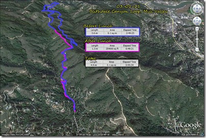
This 4.9 mile hike starts in the redwood-lined bottom of the canyon, ascends northward up the Corte Madera Ridge Fire Road, switches back southeast on H-Line Fire Road, drops down to the level Southern Marin Line Fire Road, nearly reaches Crown Road, then climbs steeply back to the southwest through the forest on the Hoo Koo E Koo Trail to the Blithedale Ridge Fire Road, before looping back down into the canyon again.

x-GoogleEarth-WithStats

Water storage tanks along the first uphill section of the hike are a popular place for graffiti artists to display their skills.  One such “painting” is very fitting since we always encounter a number of dog-walkers on this outing.

Trail Dog

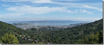
This could be a very miserable place to hike on a wet, windy day, since only the uphill section on the Hoo Koo E Koo Trail has ample cover from the tree canopy.  But as has been the case in recent years, we once again had bright sunny skies filled with wispy clouds high above the view across the Bay to Mount Diablo where we stopped for lunch.

P1090426-7 _LookingEast

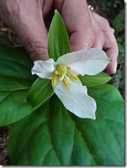
P1090406-WakeRobinWake Robin Trillium,  Shooting Stars, Indian Paintbrush, Indian Warriors, and Hound’s Tongue were some of the blooming plants that we passed as we climbed about 600’ feet over the course of 3.5 miles before losing all of our gains over the final 1.4 miles of the hike.

Three hours, fifty-five minutes, and thirty-four seconds after we started out we were back at creek-side in Blithedale Canyon, tossing our gear back in our cars.

Sunday, March 6, 2011

Blithedale Canyon Hike Photos Now On-Line!

Photos taken by Theresa Fisher and Dick Jordan during last week's Blithedale Canyon Loop hike are now on-line. 

View them on the blog or click here for the on-line photo album.

Saturday, March 5, 2011

Spring 2011 Tuesday Hike Schedule Now On-Line!

The detailed list of Spring 2011 Tuesday hike descriptions is now on-line.  (Click here to view it). The first Spring hike is on March 29th. 

The last Winter 2011 hike is on March 15th.

There is no hike on March 22nd.

Butterflies, Wildflowers, & Tidepooling with Wendy

Can't get enough of the natural world meandering with Wendy?  Join her for these outings offered through the Field Seminar Programs of the Point Reyes National Seashore Association this Spring:
  •  The Magic of Minus Tide at Duxbury Reef, Friday, May 20 or Saturday, June 18

Wednesday, March 2, 2011

Remembering Silvia Lange

Silvia's Birthday Serenade for Wendy Now gone for over a year, but never forgotten, is our singing Meanderer Silvia Lange, who was swept out to sea while walking her service dog, Hettie, on North Beach at Point Reyes National Seashore in January of 2010.

On the weekend of March 19-20, there will be two events held to help us remember Silvia.  Let Wendy (bdreskin@comcast.net, 415 457-3949) know if you plan to attend either one or both.

Cenotaph Dedication

On Saturday, March 19, 2011 at 1:00 p.m., please join Silvia's family for the dedication of a cenotaph at Oakland’s Mountain View Cemetery, the cemetery where she was a docent for so many years.  (A cenotaph is a marker where there is no body.)  Her fellow docents have selected a spot just above the  grave of one of her favorites, 1930s bandleader Anson Weeks. Bring your memories to share. Light refreshments will be served afterwards.

Angel Island Bench Dedication

On Sunday, March 20, 2011, a bench will be dedicated in Silvia’s honor on the top of Mount Livermore at Angel Island State Park where she also worked as a docent.  We will meet at 11:15 in Ayala Cove on Angel Island. (Click here for the Angel Island-Tiburon Ferry schedule).

At 11:30 we will hike up the Sunset Trail to the top of Mount Livermore.  There will be a vehicle to transport anyone who can't hike, but it can only go to within 1/4 mile of the top. At 1 PM we will dedicate the new bench honoring Silvia.  At that time we will share our memories, read some of her poetry, and perhaps even sing a song or two!
 
We will hike back down at 1:30, stopping at Silvia's favorite tree.  Plan on bringing a picnic lunch and water.  We plan to share dessert back at Ayala Cove before our time together ends. Please bring a dessert and your stories and memories of Silvia.

(Click here to read more about Silvia and last year’s celebration of her life held on Angel Island).

Sign Up For Spring Hikes!

Computer With Man with Question Mark Registration for the Spring Meandering in Marin hiking series began at the College of Marin on Monday. February 28th.  If you haven’t signed up as yet, here’s how to do so:

  1. Start the registration process at the MyCOM Portal (https://mycom.marin.edu/cp/home/displaylogin).
  2. Enter your User Name and Password if you’ve registered on-line since the new system went into place.  (If you don’t have a User Name and Password, Dick suggests calling the phone number for “Older Adults” and asking for assistance: 415-485-9305).
  3. Click on the “Student” tab.
  4. Click on “Register, Add or Drop Classes”
  5. In the “Select a Term” box pick “Spring 2011 Community Ed.”
  6. Click the “Submit” button.
  7. Under the “Add Classes Worksheet” near the button of the page, in the boxes under CRNs, enter 35021 for the Tuesday class.  (Monday is 35020).
  8. Click on “Submit Changes.”
  9. Paying the $120 class fee with a credit card via the Community Ed Website’s “E-Cashier” now works, although the process for doing so seems overly elaborate.
  10. You can always register via mail, fax (415 460-0773), or in person if you are unable to sign up for classes on-line.  Click here for more information.

Tuesday, March 1, 2011

Deer Park to Phoenix Lake Hike (3/8) Preview

This is a scenic hike with lunch at Phoenix Lake.  We should see red larkspur, gypsum spring beauty, baby blue eyes, and ground iris  Maybe we'll hear the first orange-crowned warblers of the season!  (Click here for a recap of our hike in March 2010).

Directions to trailhead:  Go west on Sir Francis Drake Boulevard to Fairfax. As you enter Fairfax, turn left at the gas station, and make an immediate right in front of the movie theater. This puts you on Broadway. Make the first left onto Bolinas Avenue. Just after it veers left, turn left on Porteous Avenue. Follow it to the parking lot at Deer Park. 
15 minutes from College of Marin. Restrooms at trailhead. Carpoolers can meet at St. Rita's Church at 9:30 a.m. (Click here for a Google Map showing the area near the trailhead and for driving directions).

Weather forecast:  As of Tuesday afternoon, March 1, the National Weather Service forecast for the hike was partly sunny, with a slight chance of showers and a high near 56.(Click here for an updated forecast).

More on this hike: Presumably we'll follow the same route as last year. The Martin's Hiking in Marin trail guide does not have a single map and directions for our hike from Deer Park School to Phoenix Lake and back, but you can use the following two maps and hikes from their book to piece together our path:

Start off using the Martin's Hike "C6 - Deer Park Road - Yolanda Trail". Head up the Deer Park Fire Road to Oak Tree Junction, then turn left (to the south) and hike uphill on the Six Points Trail. When you reach the Six Points junction, switch to Hike "C4 - Hidden Meadow - Yolanda Trail" and hike down the Yolanda South Trail to Phoenix Lake.

Using that same hike and map, follow Shaver Grade uphill, and while doing so, refer back to the C6 hike and map to follow the Grade to Five Corners. Continue straight down Deer Park Fire Road to Boy Scout Junction. Cross the fire road and take the Junction Trail back to its intersection with Deer Park Fire Road (just where you turned off onto Six Points Trail when you were headed toward the lake).

MMWD has a printable map of its watershed which shows these trails, and here's a Google Earth view looking from Deer Park over Bald Hill towards Phoenix Lake. We'll head from bottom to top and a little left of center in this picture to reach the lake, then turn right at the lake and go from top to bottom by starting up Fish Gulch (shown in purple lettering on the photo) and onto the Shaver Grade (shown in white lettering). Click on the photo to open a larger image in your Web browser.