
Tuesday, December 24, 2013
Happy Holidays from The Meandering Blog!
Happy Holidays from the Meandering Blog! See you on the trail next year!
Friday, December 20, 2013
Winter 2014 College of Marin Hike Information Now Online!

Click here for information on the Tuesday hike series.
Click here for information on the Monday hike series .
Tuesday, December 17, 2013
Meandering in 2013: It's A Wrap!
Alas, after ending today's Sky Trail to Bear Valley hike, there will be no more Meandering in Marin for us during the final two weeks of 2013!

Enjoy the holiday break from huffing and puffing up the trail!
We resume our Tuesday treks on January 7, 2014 when we do the one-way Pine Mountain/Elliott Nature Preserve shuttle hike in Fairfax.
(Registration for the College of Marin Winter 2014 hike series will open on January 2, 2014.)
Enjoy the holiday break from huffing and puffing up the trail!
We resume our Tuesday treks on January 7, 2014 when we do the one-way Pine Mountain/Elliott Nature Preserve shuttle hike in Fairfax.
(Registration for the College of Marin Winter 2014 hike series will open on January 2, 2014.)
Monday, December 16, 2013
Winter 2014 COM Hike Series Registration
Registration begins on Thursday, January 2, 2014. Look for more information from Wendy by or before that date.
Friday, December 13, 2013
Lake Lagunitas "Final Exam" Hike Photos Now Online!

View them on the Meandering blog or click here for the on-line album.
Tuesday, December 10, 2013
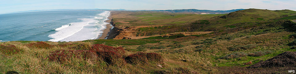
Sky Trail to Bear Valley Hike (12/17) Preview
 We return to Point Reyes National Seashore on Tuesday, December 17th for our the last outing of 2013.
 The trail is about 7.3 miles long, but a lot of it is fairly level, so the hike is a bit easier than the distance implies.
This is a shuttle hike, so CALL WENDY AT 457-3949 or send her an e-mail her at bdreskin@comcast.net if you are coming!
Note the earlier than usual meeting time at Bear Valley.
Directions to trailhead: We’ll meet at Bear Valley at 9:20 a.m. and carpool to Sky Trail.
(Click here for a MapQuest map showing the trailhead location; click on "Get Directions" at the top left side of the map and enter your location to get driving directions and estimated travel time from your location).
When we get to Mt. Wittenberg we’ll go down Old Pine to the Bear Valley Trail. Maybe by this time mushrooms will be up!
We’ll need some people who are not in a rush to drive people back to Sky Trail after we reach the Bear Valley Visitor Center and parking lot.
Restrooms at Bear Valley, none at Sky Trail trailhead, but some as we pass Coast Camp.
Carpool leaves St. Rita Church in Fairfax at 8:45 a.m.
(Click here for a MapQuest map showing St. Rita's, and directions and estimated driving time to the trailhead from there.)
Weather forecast: As of Tuesday afternoon, December 10th, the National Weather Service forecast for the hike was mostly sunny, with a high near 62. (Click here for an updated forecast).
More on this hike: "G3 Sky Trailhead to Bear Valley" in the Martins' book, Hiking Marin, is a version of this hike although we usually go straight at Junction #1 shown on their map and continue on to Sky Camp rather than take the detour up to Mt. Wittenberg (which we do on a separate loop hike from the Sky Trail trailhead) and then back down to the Sky Trail before continuing on to the Old Pine Trail, Divide Meadow and on to Bear Valley. (Click here for the Seashore's South District Hiking Map which shows these trails).
The following Google Earth image gives a bird's eye view of where we'll be hiking:

Quit Griping About the Cold Weather!
 To say that it was not warm on today's hike would be a gross understatement. It was at least as cold as if not colder when the muddle puddles in the trail were frozen solid during our December 8, 2009 hike.
The outside thermometer on Dick Jordan's car registered 42 degrees when he arrived at the Lake Lagunitas parking lot, and just 46 degrees when we finished our hike.
But, per this story on The Slatest, we could have been hiking in the Antarctic where +42 F would have felt balmy compared to the -135.8 F record lowest-on-earth temperature recorded there.

Early morning frost warnings in Marin should end by Friday of this week, and it should reach a pleasant 62 degrees (above zero) when we hike at Point Reyes National Seashore next Tuesday.
Monday, December 9, 2013
Bahia Hike Photos Now Online!
View them on the Meandering blog or click here for the on-line album.
Thursday, December 5, 2013
Muir Woods Hike Photos and Video Now Online!
View them on the Meandering blog or click here for the on-line album.
And here's a short YouTube video Dick Jordan made from clips filmed during the hike.
"WINTERIM" 2013-2014 HIKE SCHEDULE NOW ONLINE!

Click here for details on all of the "Winterim" hikes.
Lake Lagunitas “Final Exam” Hike (12/10) Preview
 We
return to the MMWD watershed for our final hike of the Fall 2012 "2"
session. Here's what we'll be doing: "We make a partial circle around
the lake, looking for ring-neck ducks, mergansers, grebes and other
birds, and then make a loop past Pilot Knob, returning on Southern Marin
Line. We usually see newts and some mushroom on this hike."
We
return to the MMWD watershed for our final hike of the Fall 2012 "2"
session. Here's what we'll be doing: "We make a partial circle around
the lake, looking for ring-neck ducks, mergansers, grebes and other
birds, and then make a loop past Pilot Knob, returning on Southern Marin
Line. We usually see newts and some mushroom on this hike."Bring your contribution to our gourmet feast, plus a plate, utensils, and a cup." (Click here for a recap of our December 2009 "Final Exam" hike at this location).
Directions to trailhead: Take Sir Francis Drake Boulevard into Fairfax. Jog left and make an immediate right in front of the movie theater. The first left puts you on Bolinas Avenue. Follow this until you see the sign on your left for Lake Bon Tempe and Lake Lagunitas. Follow the road to the toll booth by Sky Oaks Ranger Station. Then continue past to toll booth until you reach the end of the road.
(Click here for the MMWD map and directions. Or click here for a MapQuest map showing the trailhead location; click on "Get Directions" at the top left side of the map and enter your location to get driving directions and estimated travel time from your location).
The day use fee is $8. You can use $1, $5, or $10 bills and coins at the automated pay station, or a Visa or Mastercard.
Annual entrance passes are normally $60 ($30 for those 62 and older), but after September 1st you can buy one for half of those prices and the pass will be valid through January 31, 2014. (You can pay the annual pass fee at the automated pay station. Keep one part of the receipt which is a temporary pass good for two weeks, then: 1) stop at the Sky Oaks Ranger Station on the way out and ask them to send the other half of your receipt to the main office in Corte Madera which will issue the permanent pass and mail it to you, or 2) send or take the receipt to the main office yourself).
Time: 30 minutes from College of Marin. Outhouse in parking lot.
Carpoolers can meet at St. Rita's Church at 9:20 a.m. (Click here for a MapQuest map showing the St. Rita's, and directions and estimated driving time to the trailhead.)
Weather forecast: As of Thursday December 5th, the National Weather Service forecast for the hike was mostly sunny, with a high near 61. (Click here for an updated National Weather service forecast).
More on this hike: Hike "C16 - Lakeview FR to Pilot Knob" in the Martin's book, Hiking Marin, sets out a shorter hike than we'll be doing; instead of following the Pilot Knob trail back to the parking lot, we'll take a longer route back by continuing eastward and then looping back the west, picking up the Southern Marin Line Road (called the Filter Plant Road on the Martin's map). (Click here to view, zoom in on, and print a map of the MMWD watershed lands).
Although this is the final hike of the College of Marin Fall 2 session, we'll do the first "Winterim" hike on December 17 up Sky Trail to Bear Valley.
Tuesday, November 26, 2013
NEW! Get Driving Directions and Time to Trailhead on Your Smartphone!
The hike previews posted on the Meandering blog and sent to you via e-mail will now contain links to two separate MapQuest maps that will allow you to get turn-by-turn directions and estimated driving time based on current traffic conditions to the trailhead from either:
 Just click on the link to the desired map in the hike preview e-mail and it should open the MapQuest map on your computer.
If you have the free MapQuest app installed on your iPhone or your Android smartphone, simply click on the link to the desired map in the hike preview e-mail to open the MapQuest map on your smartphone, and get the driving directions/driving time..
(If you downloaded the hike preview to your computer, you may have to forward it to yourself, then download it to your phone. You can also open a map on your computer, click on "SEND" on the top right-hand side of the map and forward it to your phone via e-mail or if you click on "Mobile," via text message.)
Let Dick Jordan know if you have any questions or problems.
- Your home or other "Current Location"
- The carpool meeting place.
If you have the free MapQuest app installed on your iPhone or your Android smartphone, simply click on the link to the desired map in the hike preview e-mail to open the MapQuest map on your smartphone, and get the driving directions/driving time..
(If you downloaded the hike preview to your computer, you may have to forward it to yourself, then download it to your phone. You can also open a map on your computer, click on "SEND" on the top right-hand side of the map and forward it to your phone via e-mail or if you click on "Mobile," via text message.)
Let Dick Jordan know if you have any questions or problems.
Bahia Open Space Hike (12/3) Preview
 For
our next hike we'll head north to the Novato area and do some bird
watching on a portion of the Marin County Open Space lands. (Click here for a recap of our 2009 hike).
For
our next hike we'll head north to the Novato area and do some bird
watching on a portion of the Marin County Open Space lands. (Click here for a recap of our 2009 hike).Here's Wendy's description of the outing: "This is a wonderful birding area! I'll bring a spotting scope, but bring binoculars if you have them. We can expect about ten species of ducks, as well as stilts, avocets, grebes, raptors and songbirds.”
Directions to trailhead: Take Highway 101 and exit on Atherton Avenue in Novato. Go east, until Bugeia Lane splits left and Atherton goes right. Take Bugeia which becomes Bahia and park at the end of the street.
(Click here for a MapQuest map showing the trailhead location; click on "Get Directions" at the top left side of the map and enter your location to get driving directions and estimated travel time from your location).
Driving time from College of Marin: 35 minutes. No restrooms.
Carpoolers can meet at 9:20 a.m. at the Terra Linda Park & Ride lot on the east side of Highway 101 at the Smith Ranch Road exit. (Click here for a MapQuest map showing the Park & Ride location, and directions and estimated driving time to the trailhead.)
Weather forecast: As of Tuesday, November 26th, the weather forecast for this hike was a slight chance of rain. Mostly sunny, with a high near 55. (Click here for an updated National Weather Service forecast).
More on this hike: Hiking in this particular areas isn't covered by any of the trail guides which Dick Jordan has, but you can click here for the Marin County Open Space District's description of the Rush Creek area.
Wednesday, November 20, 2013
Muir Woods (Dipsea to Ben Johnson) Hike (11/26) Preview
 This week we head south in the County and back into the federal
parklands. Here's Wendy's description of the hike: "Instead of racing
up the Dipsea, we’ll stop to admire ancient redwoods, beautiful views,
and hopefully some mushrooms." (Click here to read the recap of our 2/10/09 hike on these trails. You can view photos taken on previous hikes.)
This week we head south in the County and back into the federal
parklands. Here's Wendy's description of the hike: "Instead of racing
up the Dipsea, we’ll stop to admire ancient redwoods, beautiful views,
and hopefully some mushrooms." (Click here to read the recap of our 2/10/09 hike on these trails. You can view photos taken on previous hikes.)Directions to trailhead: From Highway 101 take the Stinson Beach exit, turn left (west) on Shoreline Highway, right on Panoramic Highway and left on Muir Woods Road. Meet at Muir Woods Parking Lot #2.
Time: 35 minutes from College of Marin. Restrooms at trailhead. (Carpoolers can meet at the Greenbrae Park & Ride lot near the intersection of Sir Francis Drake Boulevard and Highway 101 at 9:10 am).
Weather forecast: As of Wednesday, November 20th, the National Weather Service forecast for the hike was sunny, with a high near 70. (Click here for an updated forecast).
More on this hike: We'll hike up the Dipsea Trail, then descend back to the floor of Muir Woods on the Ben Johnson Trail. (Click here to view and download the park trail map). If you have Tracy Salcedo-Chourre's book, Exploring Point Reyes National Seashore and Golden Gate National Recreation Area, you'll see that she proposes hiking this route in the reverse direction (up the Ben Johnson, down the Dipsea) from our plan, but her book will at least give you an idea of what our hike will be like.
Saturday, November 16, 2013
Boojtack to Mt. Theater and West Point Inn Hike (11/19) Preview
A mostly shady trail takes us up to the Mountain Theater where you’ll
learn the history of its construction and the tradition of drama* on the
Mountain. Lunch at the historic West Point Inn.
(*The Mountain Theater - a.k.a. The Cushing Memorial Theater- in Mount Tamalpais State Park
was constructed by the Civilian Conservation Corps in the 1930s. The
natural-stone amphitheater seats 3,750 people and features the Mountain Play each spring, produced every year since 1913). (Click here for a recap of our February 9, 2010 hike. You can view photos from a previous hike in our online album).
Tamalpais State Park
was constructed by the Civilian Conservation Corps in the 1930s. The
natural-stone amphitheater seats 3,750 people and features the Mountain Play each spring, produced every year since 1913). (Click here for a recap of our February 9, 2010 hike. You can view photos from a previous hike in our online album).
.
Directions to Trailhead: Take the Stinson Beach/Highway 1 exit off Highway 101. Go west through Tam Valley and up onto the ridge. Turn right onto Panoramic Highway and follow signs to Mt. Tamalpais. Bootjack is about 2 miles past Mountain Home.
As you drive up the mountain, look for the Bootjack picnic area and parking lot ($8/car, $7 for seniors, if you don't have a state park pass) on your right --- if you get to Pantoll at the crest of Panoramic Highway, you've gone too far and need to turn around and drive back down the mountain. (Click here for a map of Mt. Tam that you can view and print out).
Restrooms at trailhead (one at Bootjack will be closed through June, but the other should be open) and lunch stop. Driving time from College of Marin: 55 minutes. Carpoolers meet at Greenbrae Park & Ride Lot at 9:00 a.m.
Weather forecast: As of Saturday, November 16th, the National Weather Service forecast for the hike was cloudy, with 50 percent chance of rain and a high near 57. (Click here for an updated forecast).
More on this hike: Hike "B12 Bootjack - Rock Springs Trails" in the Martins' book, Hiking Marin, shows the trails we'll take. (Click here to view a copy of the Mount Tamalpais State Park brochure; the park map on the last page shows the trails).
(*The Mountain Theater - a.k.a. The Cushing Memorial Theater- in Mount
Tamalpais State Park
was constructed by the Civilian Conservation Corps in the 1930s. The
natural-stone amphitheater seats 3,750 people and features the Mountain Play each spring, produced every year since 1913). (Click here for a recap of our February 9, 2010 hike. You can view photos from a previous hike in our online album)..
Directions to Trailhead: Take the Stinson Beach/Highway 1 exit off Highway 101. Go west through Tam Valley and up onto the ridge. Turn right onto Panoramic Highway and follow signs to Mt. Tamalpais. Bootjack is about 2 miles past Mountain Home.
As you drive up the mountain, look for the Bootjack picnic area and parking lot ($8/car, $7 for seniors, if you don't have a state park pass) on your right --- if you get to Pantoll at the crest of Panoramic Highway, you've gone too far and need to turn around and drive back down the mountain. (Click here for a map of Mt. Tam that you can view and print out).
Restrooms at trailhead (one at Bootjack will be closed through June, but the other should be open) and lunch stop. Driving time from College of Marin: 55 minutes. Carpoolers meet at Greenbrae Park & Ride Lot at 9:00 a.m.
Weather forecast: As of Saturday, November 16th, the National Weather Service forecast for the hike was cloudy, with 50 percent chance of rain and a high near 57. (Click here for an updated forecast).
More on this hike: Hike "B12 Bootjack - Rock Springs Trails" in the Martins' book, Hiking Marin, shows the trails we'll take. (Click here to view a copy of the Mount Tamalpais State Park brochure; the park map on the last page shows the trails).
East Peak Hike Photos Now Online!
View them on the Meandering blog or click here for the on-line album.
At Home with The Birds
The birds we see during hikes might nest in hole in a tree, in a twig-built nest on a branch, or on the ground.
But what's it like inside of a man-made birdhouse? Take a look.
(Click here if the video player doesn't appear)
The ad is part of a campaign by the British company, Robinson's, and the RSPB, to protect British birds and wildlife.
But what's it like inside of a man-made birdhouse? Take a look.
(Click here if the video player doesn't appear)
The ad is part of a campaign by the British company, Robinson's, and the RSPB, to protect British birds and wildlife.

Sunday, November 10, 2013
California Legacy Project Film Premier, Nov. 21 at Dominican U
This event abut an the upcoming documentary film Becoming California about Point Reyes is something you may want to attend.

Here's the information on the showing provided by the Point Reyes National Seashore Association:
Here's the information on the showing provided by the Point Reyes National Seashore Association:
California Legacy Project Film Premier
Thursday, November 21st
6 pm - 8 pm, screening at 7pm
Angelico Hall, Dominican University
50 Acacia Avenue, San Rafael
refreshments * free parking * wheel chair accessible
Join
us for the premiere of a very special short film about Point Reyes
National Seashore. Narrated by Jane Fonda and featuring extraordinary
cinematography, this 20-minute film tells the remarkable story of how
natural and human change have created the park we know today and how we
can be a force of positive change in the future. The film's incredible
story of the park will inform and inspire visitors at the Bear Valley
Visitor Center.
The evening will begin with a reception, followed by a trailer for Becoming California,
a new public television documentary about the Point Reyes film. After
the films there will be a chance for Q&A with the producers.
A production of the California Environmental Legacy Project, the Becoming California
documentary takes a fresh look at our past, present and future
relationship with California's natural environment. Not the tired old
tale of people versus nature. But a new story. A story about how nature
and civilization need not be adversaries but partners - together
creating healthy, sustainable environments amidst vibrant economies. The
film is slated to air in spring 2014 and will highlight Point Reyes.
For more information about the project visit: www.calegacy.org
Or email RSVP or call (415) 663.1200 x 304 for more information.
|
Thursday, November 7, 2013
Sky Oaks MMWD Hike (11/12) Preview
This week we'll in the MMWD watershed near Fairfax. Here's Wendy's description of the hike:
"This loop starts out in oak/bay/madrone habitat, but we'll also see redwoods and some grassland. We often see a large variety of mushrooms on this hike!"
 Directions to trailhead: Take
Sir Francis Drake Boulevard into Fairfax. Jog left and make an
immediate right in front of the movie theater. The first left puts you
on Bolinas Avenue. Follow this until you see the sign on your left for
Lake Bon Tempe and Lake Lagunitas. Follow the road to the toll booth by
Sky Oaks Ranger Station. Park at the dirt parking lot on the right, just past the toll station. (Click here for the MMWD map and directions).
Directions to trailhead: Take
Sir Francis Drake Boulevard into Fairfax. Jog left and make an
immediate right in front of the movie theater. The first left puts you
on Bolinas Avenue. Follow this until you see the sign on your left for
Lake Bon Tempe and Lake Lagunitas. Follow the road to the toll booth by
Sky Oaks Ranger Station. Park at the dirt parking lot on the right, just past the toll station. (Click here for the MMWD map and directions).
The day use fee is $8. You can use $1, $5, or $10 bills and coins at the automated pay station, or a Visa or Mastercard.
Annual entrance passes for Marin residents are normally $60 ($30 for those 62 and older), but after September 1st you can buy one for half of those prices and the pass will be valid through January 31, 2014. (You pay the annual pass fee at the automated pay station, then have to either stop at the Sky Oaks Ranger Station on the way out and ask them to send your receipt to the main office in Corte Madera which will issue the pass and mail it to you, or you have to send or take the receipt to that office yourself).
Time: 25 minutes from College of Marin. Portapotty in parking lot. Carpoolers can meet at St. Rita's Church at 9:25 am.
Weather forecast: As of Thursday, November 7th, the weather forecast for this hike was a slight chance of rain. Mostly cloudy, with a high near 71. (Click here for an updated National Weather service forecast).
More on this hike: Hike "C12 Taylor-Concrete Pipe-Bullfrog FR" in the Martins' book, Hiking Marin, shows the area where we will be hiking (our route may differ) in this part of the MMWD watershed. (Click here to view and print the MMWD map of this area).
"This loop starts out in oak/bay/madrone habitat, but we'll also see redwoods and some grassland. We often see a large variety of mushrooms on this hike!"
 Directions to trailhead: Take
Sir Francis Drake Boulevard into Fairfax. Jog left and make an
immediate right in front of the movie theater. The first left puts you
on Bolinas Avenue. Follow this until you see the sign on your left for
Lake Bon Tempe and Lake Lagunitas. Follow the road to the toll booth by
Sky Oaks Ranger Station. Park at the dirt parking lot on the right, just past the toll station. (Click here for the MMWD map and directions).
Directions to trailhead: Take
Sir Francis Drake Boulevard into Fairfax. Jog left and make an
immediate right in front of the movie theater. The first left puts you
on Bolinas Avenue. Follow this until you see the sign on your left for
Lake Bon Tempe and Lake Lagunitas. Follow the road to the toll booth by
Sky Oaks Ranger Station. Park at the dirt parking lot on the right, just past the toll station. (Click here for the MMWD map and directions). The day use fee is $8. You can use $1, $5, or $10 bills and coins at the automated pay station, or a Visa or Mastercard.
Annual entrance passes for Marin residents are normally $60 ($30 for those 62 and older), but after September 1st you can buy one for half of those prices and the pass will be valid through January 31, 2014. (You pay the annual pass fee at the automated pay station, then have to either stop at the Sky Oaks Ranger Station on the way out and ask them to send your receipt to the main office in Corte Madera which will issue the pass and mail it to you, or you have to send or take the receipt to that office yourself).
Time: 25 minutes from College of Marin. Portapotty in parking lot. Carpoolers can meet at St. Rita's Church at 9:25 am.
Weather forecast: As of Thursday, November 7th, the weather forecast for this hike was a slight chance of rain. Mostly cloudy, with a high near 71. (Click here for an updated National Weather service forecast).
More on this hike: Hike "C12 Taylor-Concrete Pipe-Bullfrog FR" in the Martins' book, Hiking Marin, shows the area where we will be hiking (our route may differ) in this part of the MMWD watershed. (Click here to view and print the MMWD map of this area).
Wednesday, November 6, 2013
Fog, Glorious Fog!
Not much fog hung off the coast while we were hiking on Mount Tam yesterday.
But then, it isn't summer any longer, is it?
Missing the fog? Check out this time lapse video of rivers of it flowing into the Bay.
(Click here if you don't see the video player.)
(Read Dick Jordan's short essay about fog on his Website, Tales Told From The Road.)
But then, it isn't summer any longer, is it?
Missing the fog? Check out this time lapse video of rivers of it flowing into the Bay.
(Click here if you don't see the video player.)
(Read Dick Jordan's short essay about fog on his Website, Tales Told From The Road.)
Sunday, November 3, 2013
Tennessee Valley Hike Photos Now Online!
View them on the Meandering blog or click here for the on-line album.
Thursday, October 31, 2013
East Peak Mt. Tam Hike (11/5) Preview
 This week we hike in Mount Tamalpais State Park.
This lovely loop takes up be California torreya trees with their nutmeg-like nuts, past scenic Inspiration Point, to beautiful Colier Spring where we lunch under the redwoods. We'll take Northside Trail to International Trail after lunch.
Directions to trailhead: Take the Stinson Beach/Highway 1 exit off Highway 101. Go west through Tam Valley and up onto the ridge.
Turn right onto Panoramic Highway and follow signs to Mt. Tamalpais. Keep going up the mountain, and when you get to Pantoll at the crest of Panoramic Highway (beyond Bootjack, where our hike to the Mountain Theater began), turn to the right and head uphill.
When you top out on this road, turn right and keep going until the road ends at the East Peak parking lot. (Parking costs $8/day unless you have a park pass). (Click here for a map of Mt. Tam that you can view and print out).
1 hour from College of Marin. Carpoolers can meet at the Greenbrae Parking & Ride lot at 8:55 am. Restrooms at trailhead.
Weather forecast: As of Thursday, October 31, the National Weather forecast for the hike was sunny, with a high near 71. (Click here for an updated forecast).
More on this hike: Hike "B21 Northside - Colier – Lakeview Trails" in the Martins’ book, Hiking Marin, shows the trails we’ll be taking. You can also view and the trails on page five of the Mount Tamalpais State Park brochure.
Friday, October 25, 2013
REVISED C.O.M. FALL 2 HIKE SCHEDULE
So instead of doing our first Fall 2 hike at Devil's Gulch in Samuel P. Taylor State Park on October 29th, we'll be hiking in Tennessee Valley.
You can view and print out a revised list of the C.O.M. Fall 2 Hikes that reflects this change.
Tennessee Valley Hike (10/29) Preview
 Because of the federal government shutdown, on October 15th we hiked at Devil's Gulch in Samuel P. Taylor State Park instead Tennessee Valley in the GGNRA.
Now that the U.S. National Parks have all re-opened, we'll head into the Marin Headlands and take "a loop [around Tennessee Valley which] features panoramic views of the Bay. We often see raptors here including Northern Harriers, American Kestrels, White-Tailed Kites, Red-Shouldered Hawks and Red-Tailed Hawks. When we're lucky we see bobcats!"
(Click here for a recap of our October 2008 hike. Here's an album of photos from past hikes in this area.).
Directions to trailhead: Take the Stinson Beach exit from Highway 101. Follow signs to Stinson Beach and Muir Woods, then turn left on Tennessee Valley Road and take it to the parking lot at the end.
40 minutes from College of Marin. Carpoolers can meet at the Greenbrae Park & Ride lot 9:15 am. Portable toilets at the trailhead.
Weather forecast: As of Friday, October 25, the National Weather Service forecast for the hike was partly sunny, with a high near 68. (Click here for an updated forecast).
More information on this hike: Hike A8 Miwok – Coyote Ridge – Coastal Trails in the Martin's book, Hiking Marin, shows our route from Tennessee Valley towards Mill Valley, westward to ocean views, then back east to the parking lot.
Monday, October 21, 2013
Devil's Gulch Hike (10/15) Photos Now Online!
View them on the Meandering blog or click here for the on-line album.
Thursday, October 17, 2013
Point Reyes National Seashore Update
However, Limantour Road remains closed Monday to Friday from 8:00 am to 5:00 pm while a contractor continues repairing damage to the road caused by last winter's slide. The road is open weekends.
Bear Valley Visitor Center is open 10:00 am to 5:00 pm, weekdays, and 9:00 am to 5:00 pm weekends.
The Lighthouse will be opened tomorrow. It's regular hours will be Friday through Monday, 10:00 am to 4:30 pm.
Campgrounds are open.
For additional information, call (415) 464-5137.
Some planned outings and classes offered at the Seashore by Point Reyes National Seashore Association may have been cancelled or rescheduled due to the government shutdown, and those who signed up for such events should have already been contacted by phone or e-mail.
However, the PRNSA Website says that everything scheduled for the weekend of October 19-20, 2013 will take place as originally planned.
Call PRNSA at (415) 663-1200, Extension 373, if you have any questions.
Marin Federal Parks Set to Reopen
Websites for all of these parks are now back online.
Good news for us. We should be able to hike in Tennessee Valley when the Fall 2 series of hikes kicks off on October 29th.
Tuesday, October 15, 2013
NO HIKE ON TUESDAY, OCTOBER 22ND.
Just a reminder that there will be no hike next Tuesday, October 22nd.Our next scheduled hike will be the first of the Fall 2 session on Tuesday, October 29th. Hopefully, the federal government shutdown will have ended so we can hike in Tennessee Valley in the GGNRA on that date.
Chilled Pumpkin Soup Recipe

There's no cooking required. Just put all of the ingredients into a large bowl, stir well until it's the consistency and flavor that you like, and then refrigerate.
Dick added a bit more molasses, orange and apple juice, and less whole milk and pumpkin pie spice, than the recipe calls for. He used one 29 oz can and one 15 oz can of pumpkin and got a tad over 3 quarts of soup, enough for about 16-18 small servings like we had at lunch, or around 8 large servings. He didn't add more milk the day after refrigerating the soup.
Although the soup is designed to be served chilled, you could probably gently heat it (not too much too fast or the cream might curdle) and serve it warm instead of cold.
Sunday, October 13, 2013
Devil's Gulch "Final Exam" Hike (10/15) Preview
 Since the GGNRA and the rest of the national parks are still closed as of Sunday, October 13, this week we'll head toward West Marin and stop at Samuel P. Taylor State Park for our Fall 1 "Final Exam."
We'll hike up towards, but not all the way to the summit, of Mount Barnabe, then return to the main part of the park for our gourmet potluck lunch. Bring something to share , and utensils, plate, and cup.
Here's Wendy's description of the hike: "This may be only mountain named for a mule! We’re not going all the way to the lookout on the top, so we’ll keep within our 1000’ elevation gain limit. (Mount Barnabe is 1446’; click here for photos taken from the fire lookout). The way up is longer and more gradual (about 5% grade), but you’ll want your hiking poles for the shorter fire road down. We’ll stop by the Samuel and Sarah Taylor’s grave site." (Click here for photos from one of our previous hikes.)
Directions: Take Sir Francis Drake Boulevard past the main park entrance. As you head west, watch for the sign for Devil’s Gulch on your right and the dirt parking area on your left.
Time: 40 minutes from College of Marin. No restrooms at trailhead. (Use ones at main park entrance as you pass by.) Carpoolers can meet at St. Rita's Church in Fairfax at 9:15 am.
Weather Forecast: As of Sunday, October 13th, the National Weather Service forecast for the hike was sunny, with a high near 79. Northeast wind 5 to 9 mph. (Click here for an updated forecast).
More On This Hike: Hike "D11 Devil's Gulch to Mt. Barnabe" in the Martins' book, Hiking Marin, shows the trails we'll follow, although we'll skip the sidetrip to the summit. You can find the trails on page 4 of the park brochure.
Saturday, October 12, 2013
Indian Tree Hike (10/8) Photos Now Online!
View them on the Meandering blog or click here for the on-line album.
Friday, October 11, 2013
KQED'S Guide to Bay Area Public Spaces
KQED has just announced its online "A Guide to Public Space in the Bay Area."

The guide covers:
The guide covers:
- National Park Service and federal recreational properties
- State parks and other state-managed or -owned recreational properties
- Regional and county parks
- City parks
- Utility district watershed lands
- Locally owned and managed open space
- Nonprofit- or trust-owned open spaces
Thursday, October 10, 2013
Next Week's "Final Exam" Location "To Be Announced"
 Thanks to closure of the federal parks in Marin, the location of our Fall 1 "Final Exam" hike and luncheon is up in the air.
Plan "A" was go to Tennessee Valley in the GGNRA. But right now, hiking there might win you a free, all-expenses-paid trip to "Gitmo" for trespassing.
With luck, the GGNRA will be open for business next Tuesday. But failing that, Wendy will come up with a Plan "B" for us to finish up our first series of fall hikes.
You can read more about the park closures on Dick Jordan's travel blog, Tales Told From The Road.
Samuel P. Taylor State Park Hike Photos Now Online!
View them on the Meandering blog or click here for the on-line album.
Wednesday, October 9, 2013
Vaux Swifts at McNear's Brickyard
Vaux Swifts are making their southern migration and one of their overnight roosting stops is at McNear's Brickyard in East San Rafael, just south of the Peacock Gap housing development.

Dick Jordan and his wife, Cindy, went to the brickyard with friends about 6 PM on Wednesday and saw the swifts (which zoom around like swallows) darting back and forth across the sky. About sunset (6:38 PM), they began to dive down into the is inside the brickyard's left chimney stack.

Rusty Scalf from Berkeley estimated that over 5,000 swifts entered the chimney Wednesday evening, and that they were probably part of a group that had flown in from Oregon.
On Monday, Rusty reported that:
Parking:
The entrance (McNear Brickyard Road) narrows well before it approaches the gate. At first it is rather wide with shoulders that easily accommodate parking. It is important that you not park along the entrance road beyond where the road narrows.
Park either along Point San Pedro Road or along McNear Brickyard Road at the widest part (the first ~20% of its length). This is important. There are private residences past the gate and beyond the facility; their wishes must be respected
Entering:
You may walk around the gate and enter the brickyard on foot. Never enter the manufacturing facility itself. Stay outside the brickyard area.
Do not go past the tan house on the left and the office building on the right. Stay in the employee parking area.
Organized trips:
If you are organizing a field trip it is important to contact McNear Brick & Block and give them warning as much ahead of time as possible. Email: dan@mcnear.com, phone number: 415-453-7702.
Brickyard Operations:
Occasionally their kilns operate on a 24 hour basis. When that's the case trucks might be entering and leaving, workers could be about and there is a potential to disrupt their operation. Obviously this must be avoided so please be sensitive to the possibility.
An employee of McNear Brick & Block and his family live on the upper floor of a building that is inside the brickyard. Please respect their privacy and peace and quiet.
Act like well mannered and respectful guests and feel fortunate to have such kind hosts.
Dick Jordan and his wife, Cindy, went to the brickyard with friends about 6 PM on Wednesday and saw the swifts (which zoom around like swallows) darting back and forth across the sky. About sunset (6:38 PM), they began to dive down into the is inside the brickyard's left chimney stack.
Rusty Scalf from Berkeley estimated that over 5,000 swifts entered the chimney Wednesday evening, and that they were probably part of a group that had flown in from Oregon.
On Monday, Rusty reported that:
"Last night's Vaux's Swift 'count' at McNear Brickyard was 4,280. In recent days numbers have been running between 2,000-5,000 birds. We haven's seen the huge numbers of last year when typical evenings of late Sept had 6,000 to nearly 20,000 birds. Roosts in Oregon and Washington retained very large numbers of birds until quite late this year. It's possible that the drought has suppressed insect populations and the birds are not staging as long as in previous years. In any case, this season has been quite different from the previous two years."The brickyard is private property, but Dan McNear of McNear Brick & Block, allows birders to come into the brickyard per these rules, passed along by Rusty:
Parking:
The entrance (McNear Brickyard Road) narrows well before it approaches the gate. At first it is rather wide with shoulders that easily accommodate parking. It is important that you not park along the entrance road beyond where the road narrows.
Park either along Point San Pedro Road or along McNear Brickyard Road at the widest part (the first ~20% of its length). This is important. There are private residences past the gate and beyond the facility; their wishes must be respected
Entering:
You may walk around the gate and enter the brickyard on foot. Never enter the manufacturing facility itself. Stay outside the brickyard area.
Do not go past the tan house on the left and the office building on the right. Stay in the employee parking area.
Organized trips:
If you are organizing a field trip it is important to contact McNear Brick & Block and give them warning as much ahead of time as possible. Email: dan@mcnear.com, phone number: 415-453-7702.
Brickyard Operations:
Occasionally their kilns operate on a 24 hour basis. When that's the case trucks might be entering and leaving, workers could be about and there is a potential to disrupt their operation. Obviously this must be avoided so please be sensitive to the possibility.
An employee of McNear Brick & Block and his family live on the upper floor of a building that is inside the brickyard. Please respect their privacy and peace and quiet.
Act like well mannered and respectful guests and feel fortunate to have such kind hosts.
Parking: The entrance (McNear Brickyard Rd) narrows well before it
approaches the gate. At first it is rather wide with shoulders that
easily accommodate parking. It is important that you not park along the
entrance road beyond where the road narrows. Park either along Pt San
Pedro Road or along McNear Brickyard road at the widest part (the first
~20% of its length). This is important. There are private residences
past the gate and beyond the facility; their wishes must be respected.
Entering: You may walk around the gate and enter the brickyard on foot.
Never enter the manufacturing facility itself. Stay outside the brick
yard area. Do not go past the tan house on the left and the office
building on the right. Stay in the employee parking area.
Organized trips: If you are organizing a field trip it is important to
contact McNear Brick & Block and give them warning as much ahead of time
as possible. Email: dan@mcnear.com, phone number: 415-453-7702.
Occasionally their kilns operate on a 24 hour basis. When that's the
case trucks might be entering and leaving, workers could be about and
there is a potential to disrupt their operation. Obviously this must be
avoided so please be sensitive to the possibility.
An employee of McNear Brick & Block and his family live on the upper
floor of a building that is inside the brickyard. Please respect their
privacy and peace and quiet.
Act like well mannered and respectful guests and feel fortunate to have
such kind hosts.
Thank you,
Rusty Scalf
Berkeley
- See more at: http://birding.aba.org/message.php?mesid=527981&MLID=CA09&MLNM=CA%20-%20North%20Bay#sthash.mJ5W17D1.dpuf
Sunday, October 6, 2013
California and Bay Area Park Openings, Closures
Confused about which public parks are open in California and the San Francisco Bay Area?
In today's San Francisco Chronicle, outdoor writer Tom Stienstra answers that question.

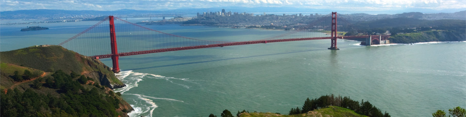
This story in the Marin I-J provides additional information on federal park closures in Marin. You can't even exit Highway 101 and drive up Conzelman Road to enjoy the view across the Golden Gate to San Francisco; that road is closed.
Don't bother going to any U.S. National Park Website for further information. They are all off-line thanks to the federal government shutdown.
In today's San Francisco Chronicle, outdoor writer Tom Stienstra answers that question.
This story in the Marin I-J provides additional information on federal park closures in Marin. You can't even exit Highway 101 and drive up Conzelman Road to enjoy the view across the Golden Gate to San Francisco; that road is closed.
Don't bother going to any U.S. National Park Website for further information. They are all off-line thanks to the federal government shutdown.
Subscribe to:
Posts (Atom)