Saturday, March 28, 2015

Lilian "Retires" From Meandering

Our Spring Meanders in Marin begin without one of our most beloved hikers: Lillian Hanahan.

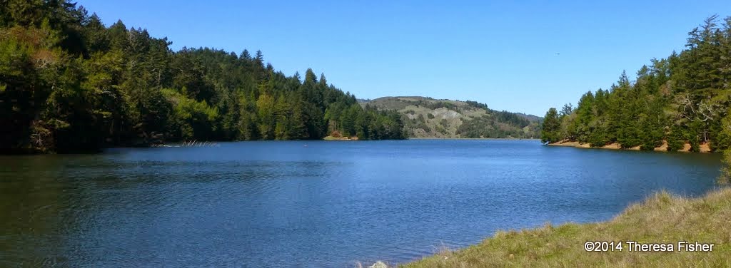
 (Theresa Fisher Photo)

After several years hiking up and down Marin County, rain or shine, Lillian decided that her last regular outing with us would be our recent "Final Exam" trek around Bon Tempe Lake.

Hopefully, Lillian will join us from time to time in the future. In the meantime, we all wish her much love and luck. We'll miss her smile a great deal, and always remember her.


Wednesday, March 25, 2015

West Ridgecrest Hike (3/31) Preview

We kick off our Spring series of Meanders on this hike (not a loop) when we’ll explore a section of the Coastal Trail with views of Stinson Beach and Bolinas Lagoon.


When Ridgecrest Boulevard opened as a toll road in the 1920s it was proclaimed California’s “Most Scenic Drive.” It’s even better hiking!

(Click here for the recap of our 2010 hike.  Photos from past hikes are in this on-line album.)

Directions to trailhead:  THERE ARE TWO WAYS TO REACH THE TRAILHEAD:
  1. Take the Fairfax Bolinas Road from Fairfax to Ridgecrest Boulevard. Park at the junction with the Fairfax-Bolinas Road. (About 1 hour driving time from the College of Marin; carpoolers can meet at St. Rita’s at 9:00 am); OR
  2. Take the Stinson Beach/Highway 1 exit off Highway 101.  Go west through Tam Valley and up onto the ridge. Turn right onto Panoramic Highway and follow signs to Mt. Tamalpais. Turn left at Rock Springs onto Ridgecrest Boulevard. Park on left at junction with the Fairfax-Bolinas Road.  (Driving time from College of Marin about 1 hour).
(Click here for a MapQuest which shows the trailhead as #1 and which can provide you with driving directions and time from your location.)

No restrooms at trailhead.

Weather forecast:  As of Wednesday, March 25th, the National Weather Service forecast for the time of the hike was sunny, with a high near 66. (Click here for an updated forecast).

More on this hike:  This hike isn’t mentioned in any of Dick Jordan’s trail guides, but we’ll be hiking south on the Coastal Trail which parallels Ridgecrest Boulevard until we reach the junction with the McKennan Gulch Trail (which heads downhill to Bolinas Lagoon) and then we will retrace our steps back north.
 
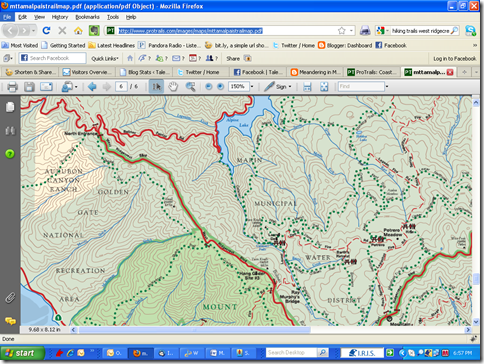
(Click here and go to page 6 of the Mt. Tam State Park brochure for the park map; click on the percentage magnification box at the top of the page and increase to about 125%-150% to get a good view of the trail which runs just west of the road).


image

Here's the hike profile.


This Google Earth image provides a bird's eye view of the route we'll take.

Drakes Bay Oyster Company Cleanup Proceeds

The Drakes Bay Oyster Company ceased operation at the end of 2014.

(Jeffrey Strain Flickr Photo) 
 
But that left the National Park Service with a major task: Removing the on-land and in-the-water traces of the commercial oyster farm. Here's the Santa Rosa Press Democrat report on how that cleanup is progressing.

Monday, March 23, 2015

Dick Jordan, Movie Star

Dick Jordan is normally "behind the camera" filming "shorts" for broadcast on MarinTV and other public access stations.

Bob Bekian Flickr Photo)

But he recently played the "Leading Man" in The White Bag, a film noir style spy thriller, filmed on location in San Rafael.

The movie should be out by summer. In the meantime, you can catch a glimpse of Dick's performance in the film's trailer.


(Click here if the YouTube video player doesn't display)

Dick is saving up his frequent flier miles in order to travel to Utah for next year's Sundance Film Festival. Look for him on the Red Carpet (or, at least, "on the carpet") at the 2016 Academy Awards in Los Angeles.

Sunday, March 22, 2015

Arch Rock Trail in Point Reyes Closed

Arch Rock, a scenic spot right on the ocean about 4 miles west of Bear Valley in Point Reyes National Seashore, has been a favorite hike destination for us during summer meanders.


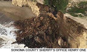
But yesterday, a portion of the trail collapsed near the rock, killing one hiker and injuring another, according to this report in today's Marin-IJ and another from ABC Channel 7 News.


 KPIX CBS Channel 5 in San Francisco filed this video report on the incident.


(Click here if the video player does not appear)

The Point Reyes National Seashore Website says that
"New hazardous conditions on Arch Rock were reported to the park on Thursday, March 19, 2015. Fissures along the top of Arch Rock had weakened the cliff."
These NPS pictures show the extent of the fissures on and near Arch Rock.

Odds are good that Arch Rock won't be a "lunch with a view" location for us anytime soon.

Wednesday, March 18, 2015

"Pre-Spring" Pine Mt./Elliott Preserve Hike (3/24) Preview

SHUTTLE HIKE - NOTE EARLY STARTING, LATE ENDING TIME 

CALL WENDY AT 457-3949 or send her an e-mail her at bdreskin@comcast.net if you are coming!

December rains cancelled this "Winterim" hike, so we'll take advantage of the two-week break between the Winter and Spring College of Marin hiking series to do a "make-up" hike.
  
This one-way shuttle hike starts in oak/bay/madrone woodland, passes through chaparral, then heads down to a valley with a stream, passing some serpentine rock areas. We'll check out birds and mushrooms as we go. There should be some interesting flowers in the serpentine areas as well as in the oak woodland. (Click here for the recap of our hike in this area in January of 2009. There are a few photos from a past hike in this area in one our online albums.)

Directions to trailhead: We need some people to meet at the end of Cascade Drive in Fairfax at 9:20 a.m. (Click here for a MapQuest map with that location and click on the #1 to get directions to it). 

If you have time pressure after class go there as well, since the car shuttle won’t get us back to the trailhead until a little after 2:00 pm. Wendy will drive those drivers to the start of the hike.

Others should meet at the trailhead by taking the Bolinas-Fairfax Road past the Meadow Club (golf course) and up to the crest of the hill. (Click here for a MapQuest map with that location and click on the #1 to get directions to it.)

Park in the parking lot across from the Pine Mountain Fire Road. It is a large dirt parking lot on your left, and the fire road is on the right. If you start going downhill and can see Lake Alpine, you’ve gone too far.  There may or may not be a porta-potty at the trailhead.

Carpool to the trailhead (not the end of Cascade Drive) will leave from St. Rita's at 9:25 a.m. (Wendy won't be at St. Rita's; she is going early to drive to the end of Cascade Drive).

Weather forecast: As of Wednesday, March 18th, the National Weather Service forecast for Fairfax on the day of the hike was partly sunny, with a high near 68. (Click here for an updated forecast).

More on this hike: We'll be hiking on both MMWD watershed lands (click here for a map that you can view, zoom in on or print) and those of the Marin County Open Space District (click here for a description of the preserve (now called Cascade Canyon Open Space Preserve instead of Elliott Preserve) on the District's Website, or click here for a map of this area).

Saturday, March 14, 2015

MCL Rush Creek Outing (March 28)

Looking for a nature outing during our Meandering layoff over the next two weeks?


On Saturday, March 28th, from 9:30 am to 12:30 pm, the Marin Conservation League will lead its 17th Walk into (Conservation) History on Saturday, March 28, at one of the best birding locations in the North Bay—Rush Creek Open Space Preserve near Novato.

This mostly level, 3-mile walk will be in the general area, although it may follow a different route, where we do our annual Bahia Open Space hike.

For details and to register for this free outing that is open to both MCL members and the general public, visit this page on the Marin Conservation League Website or phone 415-485-6257.

Wednesday, March 11, 2015

NO HIKE - MARCH 17TH

Just a reminder that the College of Marin Winter series of hikes ended yesterday.


The first hike of the Spring College of Marin Meandering hiking series will be on the West Ridgecrest Trail on Mount Tam in two weeks on Tuesday, March 31st.

Wendy may schedule a "pay-if-you-go" hike during the two-week break between the COM Winter and Spring hike series.

Tuesday, March 10, 2015

More "Otter Spotting"

We spotted an otter swimming back and forth at the west end of Phoenix Lake during our lunch break on last week's hike.

During today's "Final Exam" hike, we saw another otter swimming, diving and eating (Wendy guessed he was chomping on a crayfish) when we were about halfway around the north side of Bon Tempe Lake on the Sunnyside Trail.


The otter was too far away for Dick to photograph it, so instead he snapped this shot of the Meanderers "otter spotting." He filed an "otter spotter" report with the River Otter Ecology Project.

Zucchini-Pear Soup Recipe

Click here to view and print the recipe for the Zucchini-Pear Soup that Dick Jordan served at today's "Final Exam" luncheon.

Dick used Red Bartlett Pears, but any pear variety should work. You could probably substitute leek for the onion, too.

The recipe calls for either chicken or vegetable stock; Dick used the latter.

The recipe says to saute the vegetables and pears in a skillet, then add broth to finish the cooking.  But if your skillet isn't deep, the broth may slop out.

To avoid making a mess in the kitchen, and the necessity of using a counter top blender or food processor to puree the soup, Dick suggests that you transfer the sauteed ingredient into a 6-8 quart pot before adding the broth, bring the soup to a boil, and then let it cool a bit (so you're not splashed with hot soup) before pureeing it with an immersion blender.

Check and adjust the seasoning when you're done. Dick added lemon juice to "brighten" the flavors.

The recipe makes about a quart and a half of soup (enough to fill about 10 of the small plastic cups Dick used to serve the soup at the "Final Exam"). Dick doubled the recipe to make enough to feed our hiking group.

Dick omitted the mint leaf garnish to speed up serving the soup after the hike, and instead, drizzled the soup with sour cream thinned with lemon juice.

You can serve this soup hot or chilled. 

Thursday, March 5, 2015

Dick Jordan's "Seals" Show

Alas, equipment woes at MarinTV scutteled the first airing of Dick Jordan's "Saving Seals By The Seashore," leaving viewers sitting around their TV sets wondering "What happened?"


But the program was broadcast yesterday evening and will be again on:

+   Mon    03/09/15    07:00 PM    Comcast Channel 26
+    Thu    03/12/15    05:30 PM    Comcast Channel 26
+    Sun    03/15/15    04:30 PM    Comcast Channel 26

Touring Battery Townsley in the GGNRA

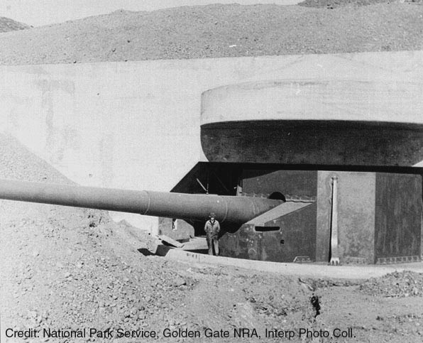
Each May when we do the Wolf Ridge hike in the Marin Headlands, we make a brief stop at Battery Townsley, one of the gun emplacements dating from the year before the U.S. entered WW II that still exists along the coast.


But when we're there on Tuesday, nothing is going on. So Marin magazine suggests that you visit on the first Sunday of the month when NPS opens the battery to the public from noon to 4 pm.


More About River Otters

While unlike yesterday, we're not often "Otter Spotters" during our Meandering hikes, those cute litter critters are making quite a comeback in Marin and elsewhere in the San Francisco Bay Area.

The following "Bay Nature on The Air" video gives an overview of the mission of the River Otter Ecology Project, headed by Dick Jordan's friend, Megan Isadore.

 
 (Click here if the YouTube Video player doesn't appear)

Wednesday, March 4, 2015

Otter Spotters

While taking our lunch break during yesterday's Deer Park to Phoenix Lake, we spotted an otter swimming back and forth at the western end of the lake.


Theresa Fisher captured this photo of the otter which Dick Jordan submitted along with an "Otter Spotter" report to the River Otter Ecology Project, headed by his friends, Megan Isadore and Terence Carroll of Forest Knolls.

The following video was shown at a gala event held by ROEP at the Bay Model last Sunday.

 
(Click here if the YouTube video player doesn't appear.)

"Snow Daze"

Anne Taylor, who hiked with us this Winter, has returned home to the Boston area where "Winter" has meant something far different this year than it has in the San Francisco Bay Area.


Here's the e-mail she sent to Dick Jordan:
"Hello Dick,

"It's Anne from Boston, emailing to say how sorry I am to miss tomorrow's hike. We returned to our home in Cambridge this past weekend, and have been trying to acclimate to all the snow. 

"Thought I would send a couple photos in case anyone from the hiking group would like to see how un-pretty the snow has become out here.

"One photo is of our back yard, the other two are photos of our street.


"Enjoy the sun and warmth out there and please give my best to the Tuesday group!

Thanks,
Anne Taylor"

Bon Tempe/Lagunitas "Final Exam" Hike (3/10) Preview


This is a lovely, level lakeside loop! We could see Ring-necked Ducks, Common Mergansers, American Widgeons, Ruddy Ducks, Buffleheads, and more.

This could also be the week for our first Acmon Blue butterfly!  (Click here for a recap of our 2010 hike. There's also an album of photos taken on past hikes.)

Remember to bring your contribution to our gourmet feast, a plate, cup, and utensils.  (We'll have lunch at Wendy's home in San Anselmo if rain - which is not likely - makes it impossible to use the group picnic area at Lake Lagunitas.)

Directions to trailhead: Take Sir Francis Drake Boulevard into Fairfax. Jog left and make an immediate right in front of the movie theater.

The first left puts you on Bolinas Avenue. Follow this until you see the sign on your left for Lake Bon Tempe and Lake Lagunitas.

Unless you have an MMWD pass, continue past the old toll booth and the Sky Oaks Ranger Station, pull over at the parking area on the right and pay the day use fee, and then continue driving until you reach the end of the road.

(Click here for the MMWD map and directions. Or click here for a MapQuest map showing the trailhead location; click on the number "1" to get driving directions and estimated travel time from your location).

The day use fee is $8. You can use $1, $5, or $10 bills (change is not given, coins aren't accepted) or Visa,  MasterCard, Discover and American Express credit cards at the two automated pay station machines which are now at the parking area just beyond the entrance station. (Note that on our November 18th Sky Oaks hike some Meanderers had difficulty getting the pay station machines to accept a credit card with a chip.)

Annual entrance passes are $60 ($30 for those 62 and older) and valid through January 31, 2015. It doesn't appear that you can purchase a pass from the new automated pay station machines. You can buy one online or by sending a check to MMWD and it will be mailed to you, or you purchase one in person at the MMWD office at 220 Nellen Avenue in Corte Madera, on the west side of Highway 101(take the southbound Lucky Drive exit).

Time: 30 minutes from College of Marin. Outhouse in parking lot.

Carpoolers can meet at St. Rita's Church at 9:20 a.m. (Click here for a MapQuest map showing St. Rita's and directions and estimated driving time to the trailhead.)

We’ll have lunch at the picnic area at Lake Lagunitas so you don’t need to carry the food for the potluck.

Restrooms at trailhead, portables en route. 

Weather forecast:  As of Wednesday, March 4th, the National Weather Service forecast for the hike was a slight chance of rain. Mostly sunny, with a high near 65. (Click here for an updated forecast).

More on this hike: Hike "C13 Bon Tempe Lake Trail" in the Martins' book, Hiking Marin, shows the general area where we will be hiking. However, we'll start and end at trail junction #2 on their map, rather than at Bon Tempe dam. (Click here for an MMWD map that shows this area).


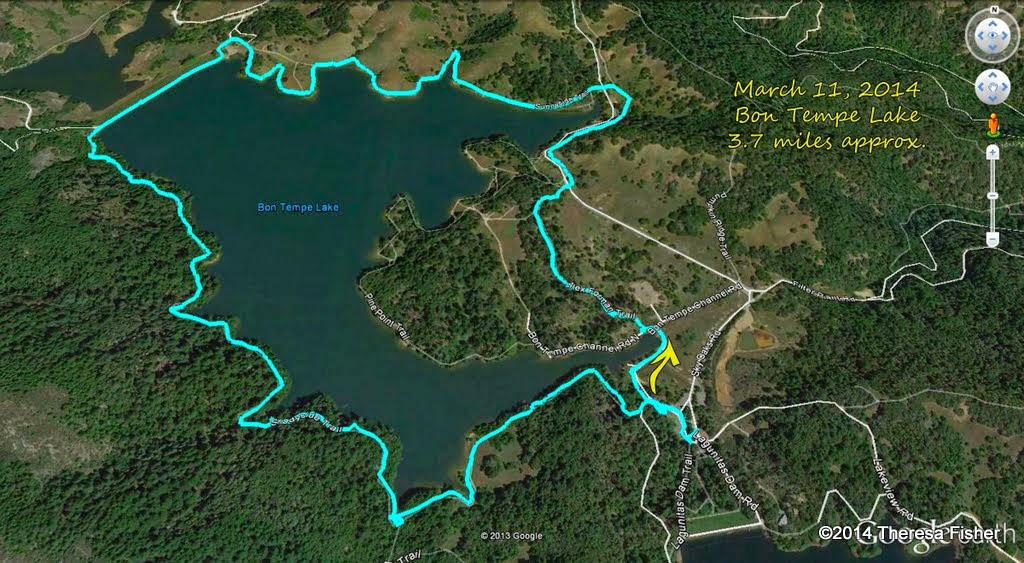
This hike is a little shorter than average at about 3.7 miles, without a great deal of elevation change.


The Google Earth image below shows both lakes in a view looking back towards Fairfax. (Click on the photo to open a larger image in your Web browser).