Saturday, June 29, 2019

Bull Point 7/2/19

"Back Off, Or Get Stomped!"This week we head through Inverness to hike on the ocean side of the Point Reyes National Seashore. Cost is $22.

Here's Wendy's description for this hike: "A beautiful but soggy (in places) walk timed to see the Coast Lilly blooming in its only site in Marin!

"Other endangered flowers we've seen other years include the Swamp Harebell, Large Flowered Lianthus, and Point Reyes Checkerbloom. We may also see Yellow-Eyed Grass, Tinker's Penny, White-Flowered Bog Orchid, and Hooker’s Evening Primrose. Some off-trail walking but little elevation gain." (Click here for the recap of our Bull Point hike on July 7, 2009.).

Directions to the trailhead: Take Sir Francis Drake Boulevard west to Olema. Turn right on Highway 1, then make an immediate left onto Bear Valley Road. Continue past the road to Park Headquarters (stop here for a restroom break; there are no porta-potties at the trailhead) and go left when you hit Sir Francis Drake again.

Go through Inverness. Go left at the "Y" (right takes you out to Pierce Point) and pass MCI and RCA stations on your right. The Bull Point parking lot will be on your left.


Carpool leaves St. Rita at 8:50 a.m.

Weather forecast: As of Saturday,June 29th, the National Weather Service forecast for the hike was mostly sunny with a high near 63. (Click here for an updated forecast).

More on this hike: Hike "H11 Bull Point and South Beach Trails" in the Martins' book, Hiking Marin, shows this as 4.0 mile out and back hike. Tracy Salcedo-Chourre's book, Exploring Point Reyes National Seashore and Golden Gate National Recreation Area, pegs it at 3.6 miles as does the park's North District Hiking Map.

The Google Earth image below shows the area where we'll be hiking. (Click on the image to open a larger version in your Web browser).

Thursday, June 20, 2019

Angel Island State Park 6/25/19

Angel Island State Park is the destination for our next summer hike.  Here's Wendy's description of the outing: Flowers, great views, and a fascinating history from when Juan Manuel de Ayala sailed the San Carlos into San Francisco Bay in 1775, through Angel Island's years as a quarantine station, its years as Fort McDowell during World War II and a Nike missile base during the Cold War. Angel Island is often good for butterflies like Anise Swallowtails, Western Tiger Swallowtails, California Sisters, and Pipevine Swallowtails.

Allow time to park and don't miss the boat! (Although it's only a 10-minute trip, the next ferry doesn't run until 11:00 a.m.)

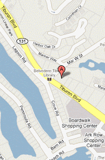
Parking gets more expensive the closer you get to the ferry. There is sometimes on-street free parking if you make a left on Mar West, the corner the library is on. (See map at left). Allow ten minutes to walk (click here to view and print walking directions) from there to the ferry.

Directions to the ferry dock: Take the Tiburon Blvd. exit from Highway 101. Follow Tiburon Blvd. to downtown Tiburon. We'll meet at the ferry dock at 21 Main Street at 9:50 a.m.

We'll take the 10 a.m. ferry from Tiburon to the island. Bring cash or check to pay for the ferry ($14.00 for Seniors, $15 for adults, covers round trip ferry and park entrance fee, pay as you board) No credit cards and no Clipper Cards. Bring $22 in cash or check for Wendy, too!

Here is a map of parking lots (cash only, no credit or debit cards, accepted) and the ferry dock provided by the Angel Island Conservancy:


Restrooms at ferry in Tiburon and on Angel Island. Carpool from Greenbrae Park and Ride at 9:10 a.m.

We'll go to the top of Mt. Livermore, eat lunch there, and take the last ferry of the day back at 3:30 p.m. Please note the late ending time.


Weather forecast: As of Thursday, June 20th, the National Weather Service forecast for Angel Island for Tuesday's hike was mostly sunny, with a high near 70. (Click here for an updated forecast).

More information on this hike: The Martin's book, Hiking Marin, sets out two hikes on the island: "A12 North Ridge Trail to Mt. Livermore" and "A13 Angel Island Perimeter Trail."

Click here to go to the Angel Island State Park page on the California State Park's Web site.  Click here for on-line information provided by the Angel Island Conservancy.

You'll find a map of the island on page 4 of the state park brochure.

Click here to listen to a podcast about Angel Island. (It may take a while for the audio player to display in your Web browser.)

Here's a Google Earth bird's eye view of the island:


Thursday, June 13, 2019

Tide Pooling with Wendy on 6/18/2019

TIDE POOLING, NO FEE 

Just a brief reminder that there is NO HIKE scheduled for June 18, but instead call or email Wendy if you'd like to join her for a 6 a.m. tide pooling adventure.

Our next hike will be on JUNE 25th,  ANGEL ISLAND STATE PARK.

(Brendon Landis Flickr Photo)

Thursday, June 6, 2019

Bolinas Ridge to Samuel P. Taylor - Shuttle Hike 6/11/19

Looking West from Bolinas Ridge (S. Walker photo)
This is another "pay-if-you-go" hike between now and the Fall 1 COM series. The cost is $22.

Directions to Trailhead:
Meet at Samuel P. Taylor State Park at 9:30 am.

Unless you have a State Park Pass, pay the $8.00 day use fee/parking if you leave your car there. 

We’ll carpool to the Bolinas Ridge trailhead and hike back down. The hike is uphill to start and then downhill and level. We could hear meadowlarks singing and see Lorquiin's admiral butterflies, western tiger swallowtails, and pipeline swallowtail caterpillars.
  
Click here for a Google Maps map showing the parking lot at Samuel P. Taylor. Click on teardrop icon on the map or on "Directions" on the left-hand side of the page for driving times and directions from your location.

Carpool leaves from St. Rita at 9:10 a.m.

Restrooms at Samuel P. Taylor, none at trailhead.

THIS IS A SHUTTLE HIKE SO CALL OR E-MAIL WENDY IF YOU'RE COMING: Home phone: 415 457-3949; cell 415 517-0488; E-mail:  bdreskin@comcast.net.

Weather forecast: As of Thursday, June 6th, the National Weather Service forecast was sunny with a high near 78. (Click here for an updated forecast).

More on this hike: "H8 - Taylor State Park to Bolinas Ridge" in the Martin's book, Hiking Marin, is a 10.2 mile loop hike which starts and ends in the state park. We're doing this hike in the opposite direction, but only one-way, from the trailhead on the south side of the road where Sir Francis Drake Boulevard reaches a crest between the McIsaac Ranch at Tocoloma (intersection of SFD and Platform Bridge Road) and Olema, so our total distance hiked should be more like 5 miles.

Although part of the area is within the GGNRA, it is actually administered by Point Reyes National Seashore. The Point Reyes Hiking Map (South District) shows the trails that we'll be following within the GGNRA.

The Google Earth image below shows the area where will be hiking viewed from just east of Olema toward Samuel P. Taylor State Park. Sir Francis Drake Boulevard is the yellow line snaking through the picture. You can see the trail beginning right off to the road on the right. (Click on the image to open a larger view in your Web browser).