We return to the MMWD watershed for our final hike of the 2018 Fall "2" session.
Here's what Wendy says we'll be doing: "We make a partial circle around the lake, looking for Ring-Neck ducks, Mergansers, Grebes and other birds, and then make a loop past Pilot Knob, returning on Southern Marin Line. We usually see newts and some interesting mushrooms on this hike."
"Bring your contribution to our gourmet feast, plus a plate, utensils, and a cup." (Click here for a recap of our December 2009 "Final Exam" hike at this location or click here for photos from past hikes.)
Directions to trailhead: Take Sir Francis Drake Boulevard into Fairfax. Turn left on Pacheco and make an immediate right in front of the movie theater onto Broadway. The first left puts you on Bolinas Avenue. Follow this until you see the sign on your left for Lake Bon Tempe and Lake Lagunitas, Sky Oaks Rd. Follow the road to the old toll booth by Sky Oaks Ranger Station.
Click here for the MMWD map and directions. Or click here for a Google Maps map showing the trailhead location; click on the teardrop icon to get driving directions and estimated travel time from your location.
Unless you have an MMWD pass, continue past the old toll booth, pull over at the parking area on the right and pay the day use fee, and then continue driving until you reach the end of the road.
The day use fee is $8. You can use a credit card, $1, $5, or $10 bills (but not coins or $20 bills) at the automated pay station which will not give you change back if you overpay.
Annual watershed area parking passes for Marin residents are $60 ($30 for those 62 and older). You can buy them online or at the MMWD main office in Corte Madera.
Time: 30 minutes from College of Marin. Outhouse in parking lot.
Carpoolers can meet at St. Rita's Church at 9:20 a.m. Click here for a Google Maps map showing St. Rita's ("A") and directions and estimated driving time to the trailhead.
Weather forecast: As of Thursday November 29th, the National Weather Service forecast for the hike was a chance of showers. Partly sunny with a high near 53. (Click here for an updated National Weather service forecast.)
More on this hike: Hike "C16 - Lakeview FR to Pilot Knob" in the Martin's book, Hiking Marin, sets out a shorter hike than we'll be doing; instead of following the Pilot Knob trail back to the parking lot, we'll take a longer route back by continuing eastward and then looping back the west, picking up the Southern Marin Line Road (called the Filter Plant Road on the Martin's map). (Click here to view, zoom in on, and print a map of the MMWD watershed lands).
Here's the route we'll follow.

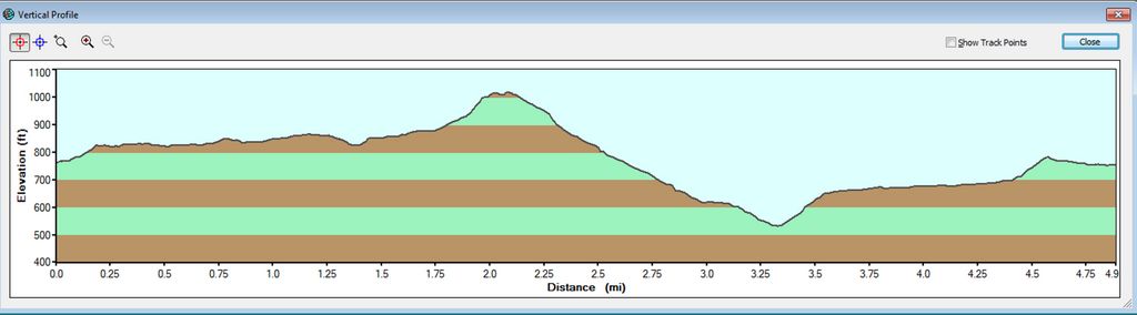
Here's the hike profile.
 This week we head south in the County and back into the federal park lands. Here's Wendy's description of the hike: "Instead of racing up the Dipsea, we’ll stop to admire ancient redwoods, beautiful views, and hopefully early mushrooms." (


 ELECTION DAY - BE SURE TO VOTE on 11/6/18
