Thursday, April 26, 2018

WOLFE RIDGE, GGNRA (5/1/18)

Here's Wendy's description of this annual Spring outing: "Wildflowers and views! 'First of spring' flowers for this hike usually include Cobweb Thistle and Bee Plant, and we sometimes see the amazing Fairy Moth hanging out by Oceanspray."  (Click here for a recap of our 2010 hike.  

Directions to trailhead: From Highway 101 southbound, take the last exit before the Golden Gate Bridge. Turn right, go under the freeway, and get in the left turn lane to go through the one way tunnel with the 5 minute traffic light. Follw the road down past the Marine Mammal Center.

Park at the end of the road. (Rodeo Beach will be on the other side of the road). (Click here for a Google Map for driving directions and times from your location.)

Time: 40 minutes from the College of Marin.

Carpoolers can meet at Greenbrae Park & Ride lot at 9:15 a.m. (Click here for a MapQuest map showing the parking lot; click on #1 to get driving time and directions from your location.)

Restrooms at trailhead. 

Weather forecast: As of Thursday, April 21st, the National Weather Service forecast for this year’s hike was sunny, with a high near 63. (Click here for an updated forecast).

More on this hike: Hike "A5 Coastal - Wolf Ridge - Miwok Trails" in the Martins' book, Hiking Marin, shows our route for this 5 mile-plus hike with a 1,000' elevation gain, as does the "Coastal-Miwok Loop" hike in Tracy Salcedo-Chourre's book, Exploring Point Reyes National Seashore and Golden Gate National Recreation Area. (Hill 88, our probable lunch spot, is 960' above sea level with lovely views on a clear day).

Here's the hike's elevation profile.


 This is the route that we'll follow.


The Google Earth photo below shows the area. (Click on it to open a larger image in your Web browser).


If you have time after the hike, stop by The Marine Mammal Center, just uphill from Rodeo Lagoon and a short distance east of the parking lot where we met for the hike.


There you are likely to see Northern Elephant Seals like the ones we saw being released at the Lifeboat Station in Point Reyes National Seashore when we hiked to Chimney Rock, California Seal Lions, Northern and Guadalupe Fur Seals, and Pacific Harbor Seals.


 (Click here for a "Patient" list.)


There should be a docent-led tour at 3:00 p.mClick here for more information about docent tours

Friday, April 20, 2018

GREEN GULCH, GGNRA, 4/24/18, NOTE CORRECTION, NOT DEER PARK TO PHOENIX,

Here’s Wendy’s description for next week's hike:  “Today we get to see the beautiful organic vegetable garden at the Zen Center’s Green Gulch Farms on our way up to the Coyote Ridge Trail. Lunch overlooking the ocean on our way back down to Muir Beach.”  (Click here for a recap or here for the on-line album of photos from a previous hike on these trails).

Directions to trailhead:  Take the Stinson Beach/Highway 1 exit off Highway 101. Go through Tam Junction, and take Shoreline Highway and follow signs to Muir Beach. (Click here for a Google Maps map that shows the trailhead parking lot. Right click on teardrop icon to get directions and driving times from your location.)

Time: 55 minutes from the College of Marin.

Carpoolers can meet at the Greenbrae Park and Ride lot at 9:00 a.m. (Click here for a Google Maps map showing the parking lot on Drakes Landing Road; right click on the teardrop icon to get driving time and directions from your location.)

Restrooms at trailhead.

Weather forecast: As of Friday, April 20th,  the forecast for the day of the hike was mostly sunny, with a high near 62.  (Click here for an updated forecast).

More on this hike:  Although our actual route may vary, hike A10 (Coastal – Coyote Ridge – Green Gulch) in the Martins’ book, Hiking Marin, covers this area.  (Click here for more information on Green Gulch Farm).

 Here's the hike profile and the route we'll follow.


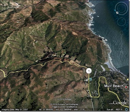
This Google Earth image shows the area where we will be hiking.

Green Gulch Google Earth View

Friday, April 13, 2018

Mount Burdell Open Space (4/17/18) Hike Preview


This week we head to the Novato area to hike on Mount Burdell.

Here's Wendy's description of the hike: "We may see Cream Cups, Tidy Tips, Baby Stars, and Balloon Clover as well as seven or eight species of butterflies. This is the only spot where Bitterroot, the Montana state flower, grows in Marin. Lunch at Hidden Lake (which given the lack of rain I expect will be Hidden Puddle or non-existent)."  (Click here for a recap of our 2009 hikeClick here for an album of photos from past hikes.)

Directions to trailhead: Take Highway 101 north and take the San Marin Drive exit. Go west on San Marin Drive. Turn right on San Andreas Drive. The entrance to the Open Space will be on your right. (If you come to the dead end of San Andreas you've gone about half a block too far.) There is no parking lot but plenty of curbside parking. There are no restrooms on this hike.

Click here for a map showing the trailhead location. Click on the teardrop to get driving time and directions from your location.

30 minutes from College of Marin.

Carpoolers can meet at 9:15 am at the Park & Ride lot on the east side of Highway 101 at Smith Ranch Road in the Terra Linda area north of the Marin Civic Center and downtown San Rafael. Click here for a map showing the location of the lot. Click on the teardrop to get driving time and directions from your location.

No restrooms on this hike, but you can use the one at the Starbuck's in the shopping center at the intersection of San Marin Drive and San Andreas Drive, just down the street from the trailhead. (Click here to get a map and driving directions.)

Weather forecast: As of Friday, April 13th, the National Weather Service forecast for the day of the hike was sunny with a high near 64. (Click here for an updated forecast).

More on this hike: Hike "E13 Old Quarry Trail to Mt. Burdell" in the Martin's book, Hiking Marin, shows the general area that we'll be hiking in, although we'll probably turn left at intersection #2 and head directly to Hidden Lake rather than climb all of the way to the summit of the mountain as shown on the Martin's map.

Click here for a Mount Burdell Open Space Preserve map from the Marin County Open Space District's Web site.

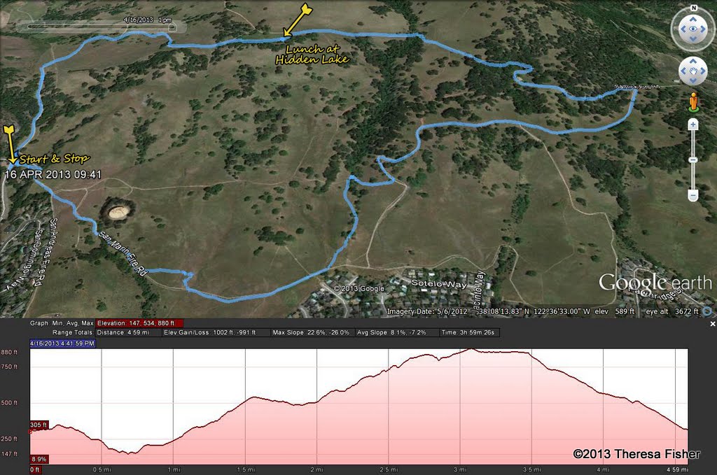
Here's the vertical profile and route for the hike.


The Google Earth image below shows where we'll be hiking. (Click on the photo to open a larger image in your Web browser).

Wednesday, April 4, 2018

CHIMNEY ROCK, PT REYES NATIONAL SEASHORE (4/10/18)

We'll return to Point Reyes National Seashore for this hike which we do every year in spring. (Click here for a recap of our 2010 trek. You can also view photos taken on past hikes.)

Here's what Wendy promises for this outing: 
"This is one of Marin's must-see spring wildflower displays.

We'll see Northern Elephant Seals at the overlook and take time to learn about their history and return from the brink of extinction. (Click here to watch Dick Jordan's "Saving Seals By The Seashore," a 3-minute "short" which aired on MarinTV.)

We often see Piegon Guiillemots, Eared Grebes in breeding plumage, Common Loons, and Savannah Sparrows on this hike. Bring binoculars if you have them."

Directions to trailhead: Take Sir Francis Drake Boulevard to Olema. Turn right at Olema onto Highway 1, then make an immediate left onto Bear Valley Road.

There are restrooms at the trailhead --- another 30-45 minutes down the road; if you need a restroom break now, take the first left off Bear Valley Road and stop at the Bear Valley Visitor Center.

Continue on Bear Valley Road until you pick up Sir Francis Drake again.

Turn left to follow Sir Francis Drake out to Point Reyes. Go through Inverness.

At the junction with Pierce Point Road, bear left and stay on Sir Francis Drake. Follow signs towards the Lighthouse and Drake’s Beach. You’ll pass the turn to Drake’s Beach on your left.

Keep going until you see a left turn to Chimney Rock. (Sir Francis Drake ends at the Lighthouse parking lot).

Driving time from the College of Marin: One hour, thirty minutes.  

(Click here for driving directions and a map showing the trailhead.)  

Carpoolers can meet at St. Rita's Church in Fairfax at 8:30 am.

Weather forecast: As of Wednesday, April 4th, the National Weather Service forecast for the Point Reyes Lighthouse area was a chance of rain and partly sunny with a high near 56. (Click here for an updated forecast).

Real-time weather reporting for the Point Reyes Lighthouse is also available (click here). Sometimes it is very windy when we do this hike, so in addition to your rain gear (if the forecast changes), be sure to toss some extra layers and a warm jacket and hat (bring some duct tape to "tie" your hat on your head) in your car in case it is "blowin' like snot" (a sailor's term for windy weather).

More on this hike: The general area covered by this hike is shown in hike "G13 PR Lighthouse and Chimney Rock" in the Martin's book, Hiking Marin and the "Chimney Rock" hike in Tracy Salcedo-Chourre's book, Exploring Point Reyes National Seashore and Golden Gate National Recreation Area.

 Click here to view and print a copy of the park map for the Point Reyes National Seashore.

You can also view and print out a map of the Chimney Rock area from the Point Reyes National Seashore Web site.

Here's the hike profile.


Here's the route we'll follow.


The Google Earth image below shows where we'll be on this outing. (Click on the photo to open a larger image in your Web browser).