Wednesday, October 24, 2018

East Peak, Mt. Tamalpais State Park 10/30/18

FALL 2  TUESDAYS INSTRUCTOR:  Wendy Dreskin TIME: 9:45 AM until 1:45 PM     
WHAT TO BRING:  Water, lunch, warm layer, hat, sunscreen. Optional equipment: hiking poles, binoculars. Walks go rain or shine, so wear raingear when appropriate. State park pass or $8 cash for parking at East Peak. MMWD pass or credit card for parking at Lake Lagunitas.     

Mount TamThis week we hike in Mount Tamalpais State Park.

This lovely loop takes us by California torreya trees with their nutmeg-like nuts, past scenic Inspiration Point, to beautiful Colier Spring where we lunch under the redwoods.

We'll take Northside Trail to International Trail after lunch.


(Click here for photos from past hikes.)

Directions to trailhead:  Take the Stinson Beach/Highway 1 exit off Highway 101. Go west through Tam Valley and up onto the ridge.

Turn right onto Panoramic Highway and follow signs to Mt. Tamalpais. Keep going up the mountain, and when you get to Pantoll at the crest of Panoramic Highway (beyond Bootjack, where our hike to the Mountain Theater begins), turn to the right and head uphill.

When you top out on this road, turn right and keep going until the road ends at the East Peak parking lot. (Parking costs $8/day unless you have a park pass).  

Click here for a Google Maps map that shows the East Peak Parking lot. Click on the teardrop icon to get driving times and directions from your location. 
  
(Click here for a map of Mt. Tam that you can view and print out).

1 hour from College of Marin.  Carpoolers can meet at the Greenbrae Parking & Ride lot at 8:55 am. Restrooms at trailhead. (Click here for a Google Maps map showing the parking lot on Drakes Landing Road; right click on the teardrop icon to get driving time and directions from your location.)

Weather forecast: As of Wednesday, October 24th, the National Weather forecast for the hike was mostly sunny with a high near 71. (Click here for an updated forecast).

More on this hike:  Hike "B21 Northside - Colier – Lakeview Trails" in the Martins’ book, Hiking Marin, shows the trails we’ll be taking.  You can also view the trails on page six of the Mount Tamalpais State Park brochure.

The following photo shows the route we'll take.


This version shows the distance we'll hike.

Here's the hike profile showing the elevation changes.


Wednesday, October 17, 2018

Estero Trail, Pt. Refer 10/23/18


Fall 2 starts with a lovely hike. This is not a loop hike, but there are marvelous views!

(Click here for a brief recap of our July 13, 2010 hike. Here's the album of photos taken during our past hikes in this area.).

Directions to trailhead:

Turn right at Olema and make an immediate left onto Bear Valley Road. (Use the restrooms at the park's Visitor Center in Bear Valley if you do not want to wait until you reach those at the trailhead). Continue until you pick up Sir Francis Drake again.

Go through Inverness and head uphill.

When you reach the turn off to the right onto Pierce Point Road, bear to the left and continue on Sir France Drake toward Chimney Rock and the Lighthouse.  Pass Mt. Vision Road on your left, and then in one mile turn left onto the road to Estero Trail.

Take this road to the parking lot at the trailhead. Click here for a Google Maps map that shows the parking lot. Click on the teardrop icon to get driving time and directions from your location.

Time: 1 hour from College of Marin. Carpoolers can meet at St. Rita's at 8:55 am.  Outhouse at the trailhead. (Pull into the Bear Valley Visitors Center area if you need an earlier restroom stop.)

Weather forecast: As of Wednesday, October 17th, the weather forecast for the hike was partly
sunny, with a high near 64.  (Click here for an updated forecast.

More on this hike: "Hike G11 Estero - Drakes Head Trails" in the Martins' book, Hiking Marin, shows where we'll be hiking, although not necessarily our exact route.

Two hikes ("Estero Trail to Sunset Beach" and "Estero Trail to Drakes Head" in Tracy Salcedo-Chourre's book, Exploring Point Reyes National Seashore and Golden Gate National Recreation Area also cover this area).

The trails are also shown on the park's North District Hiking Trails map.

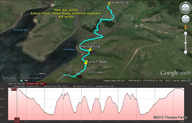
This Google Earth image gives a bird's eye view of this part of the park with the route we'll follow and the trail length and profile information. (Click on the photo to open a larger image in your Web browser).

Monday, October 15, 2018

Fall 2 2018 Hiking Schedule


TUESDAYS  FALL 2  2018 
INSTRUCTOR:  Wendy Dreskin
TIME: 9:45 AM until 1:45 PM
 
 
WHAT TO BRING:  Water, lunch, warm layer, hat, sunscreen. Optional equipment: hiking poles, binoculars. Walks go rain or shine, so wear raingear when appropriate. State park pass or $8 cash for parking at East Peak. MMWD pass or credit card for parking at Lake Lagunitas.
 
October 23  ESTERO TRAIL, POINT REYES
     This is not a loop, but there are marvelous views! 
     Take Sir Francis Drake Blvd. Turn right at Olema and make an immediate left onto Bear Valley Rd.  Continue until you pick up SF Drake again. Go through Inverness.  After the turn off to Pierce Point Road you'll pass Mt. Vision Road on your left, and then in one mile you'll come to the road to Estero Trail.  Take this road to the parking lot at the trailhead.
Time: 1 hour from College of Marin. Restrooms at the trailhead


October 30  EAST PEAK, MOUNT TAMALPAIS STATE PARK
     This lovely loop takes us by California torreya trees with their nutmeg-like nuts, past scenic Inspiration Point, to beautiful Collier Springs where we lunch under the redwoods. We’ll take Northside Trail to International Trail after lunch.
    Take the Stinson Beach/Hway 1 exit off Hway 101. Go west through Tam Valley and up onto the ridge. Turn right onto Panoramic Hway and follow signs to Mt. Tamalpais.  Keep going up the Mountain, turn right at Rock Spring, and keep going until the road ends at the East Peak parking lot. Restrooms at trailhead.
1 hour from COM.
 
 
November 6   BAHIA OPEN SPACE, NOVATO 
     This is a wonderful birding area! I’ll bring a spotting scope, but bring binoculars if you have them.  (If you don’t have any, I have extras I can loan you.)  We usually see at least eight species of ducks, as well as swans, grebes, and shorebirds.
     Take 101 and exit on Atherton Ave. in Novato. Go east, until Bugia splits left and Atherton goes right. Take Bugia, which becomes Bahia and park at the end of the street.
     Driving time from College of Marin: 35 minutes. No restrooms. 
 
 
November 13  CARSON FALLS, MMWD WATERSHED
     This hike takes us through chaparral to the beautiful falls on Pine Mountain where we’ll have lunch. 
     As you enter Fairfax on Sir Francis Drake Boulevard jog left on Pacheco when you see the movie theater and make an immediate right.  This puts you on Broadway, the street that parallels Sir Francis Drake but is on the other side of the parkade. Make the first left which is Bolinas Ave. Follow the Bolinas-Fairfax Road for about 4 miles to a dirt parking lot on your left.
 
November 20 SKY OAKS, MMWD
     This loop starts out in oak/bay/madrone habitat, but we'll also see redwoods and some grassland.  This is a good mushroom hike with Boletes, Amanitas, Waxy Caps, Milky Caps and more if we've had some rain.
       Take Sir Francis Drake Blvd. into Fairfax.  Turn left on Pacheco and make an immediate right in front of the movie theater which puts you on Broadway.  The first left puts you on Bolinas Ave.  Follow this until you see the sign on your left for Lake Bon Tempe and Lake Lagunitas. Follow the road to the tollbooth by Sky Oaks Ranger Station.  (Credit card accepted by the machine.)
      Time: 25 minutes from College of Marin. 
 
 
November 27  LAKE BON TEMPE, ROCKY RIDGE
       After we cross the dam we have about an hour of uphill walking, but we’ll take it slowly admiring the sweeping views of the lakes and checking out the early wildflowers.
     Take Sir Francis Drake Blvd. into Fairfax.  Jog left and make an immediate right in front of the movie theater.  The first left puts you on Bolinas Ave.  Follow this until you see the sign on your left for Lake Bon Tempe and Lake Lagunitas. Follow the road to the toll booth by Sky Oaks Ranger Station.  Pass the toll both and pull in to the pay area on the right.   A right turn marked Lake Bon Tempe onto a dirt road takes you to the parking lot. Portables at trailhead. Time: 25 minutes from COM.
 
 
December 4   FINAL EXAM LAKE LAGUNITAS, MMWD     
     We make a partial circle around the lake, looking for Ring-Neck Ducks, Mergansers, Grebes and other birds, and then make a loop past Pilot Knob, returning on Southern Marin Line. We usually see newts and some interesting mushrooms on this hike. Bring your contribution to our gourmet feast, plus a plate, utensils, and a cup.
      As you enter Fairfax on Sir Francis Drake Blvd. turn left on Pacheco when you see the movie theater and make an immediate right.  This puts you on Broadway, the street that parallels SF Drake but is on the other side of the parkade. Make the first left which is Bolinas Ave. Follow the Bolinas-Fairfax Rd. for about 1 mile. Turn left onto Sky Oaks Rd. You'll need to pay at the kiosk. (Credit cards accepted.) Continue to the parking lot at the end of the road.
     Driving time from College of Marin 30 minutes. Outhouse in parking lot.
 
  
-

Friday, October 12, 2018

REMINDER - NO HIKE ON TUESDAY 10/16/18

Just a quick reminder that there will be no hike this coming Tuesday, October 16, 2018.

Enjoy the lovely fall weather.


Thursday, October 4, 2018

Video of Mt Tam sent by Dick Jordan

Want to see a lovely sunrise to moonset on Mt. Tamalpais? Dick Jordan sent this along for us to all enjoy. Check it out - “Mt. Tamalpais Sunrise to Moonset” - from Gary Yost on Vimeo  at https://vimeo.com/289933681

Rock Spring, Mount Tamalpais 10/9/18 Final Hike for Fall 1

This was the hike we were supposed to take on September 25th that was cancelled because of a red flag alert. This is a classic hike on Mount Tamalpais. Wendy wrote a Marin Independent Journal article about this hike.  Click here to see Wendy's article.

Here's a brief description of the hike: Classic sites on Mt. Tamalpais popular in the heyday of hiking - Potrero Meadow Barth's Retreat and Rifle Camp. Learn about the Down and Outers Club and who Barth was!

REMEMBER TO BRING PLATE, UTENSILS, AND SOMETHING TO SHARE FOR THE GOURMET FINAL EXAM! (Let’s think green and try to cut down on paper and plastic throw-aways as much as possible). We’ll leave the food in the cars and eat when we get back, but bring your water bottle.

Directions to trailhead: Go south on Highway 101 to the Mill Valley Exit, East Blithdale. Turn left on Camino Alto (use the left turn only lane). Turn right on Miller Ave. Turn left on Montford. (The 2AM Club is the landmark.) Turn right on Molino. There is a yellow dividing line on the road so if in doubt "follow the yellow line road".  Moline becomes Edgewood, which becomes Sequoia Valley Road. At the large intersection at the top, turn right onto Panoramic Highway. At the intersection for the Pantoll Ranger Station, the road divides. Turn right onto Pantoll and keep heading uphill for about one mile. You'll come to an intersection with Ridgecrest Blvd. You'll be facing a dirt parking lot which is Rock Spring. Park here. (Click here for a map showing the parking area at the trailhead.   Click on the teardrop icon or click on "Directions" on the left-hand side of the screen to get  driving time and directions from your location.)

Driving time from College of Marin 55 minutes.


There is an outhouse at the trailhead.

Weather forecast: As of Thursday, October 4th, the National Weather Service forecast for the area around Rock Spring on Mt. Tam was sunny with a high near 68. (Click here for an updated forecast).

More on this hike: The "B17 Simmons - Potrero - Arturo Trails" hike in the Martins' book, Hiking Marin, shows the trails that we'll be hiking on, although we'll probably follow a different route (Simmons to Benstein to Potrero Meadows to Laurel Dell and back up the Cataract Trail to Rock Spring). Page 6 of the state park brochure has a trail map that shows the area.

Here's the hike profile and route we'll follow.


The Google Earth image below shows were we'll be on the mountain. (Click on the photo to open a larger image in your Web browser).