Friday, March 30, 2018

INDIAN VALLEY COLLEGE OPEN SPACE HIKE - APRIL 3, 2018

This coming week we head to Novato to hike near the Indian Valley campus of the College of Marin to kick off our series of Spring hikes.

Two loops combine to make an interesting hike. Tomcat Clover, Fiddleneck and Plectritis should be in bloom this week. We'll also see other wildflowers and early butterflies.

(Click here for a recap of our 2010 hike. You can view photos from past hikes by clicking here.)

Directions to trailhead: Take Highway 101 to the Ignacio Boulevard exit. Go west and follow Ignacio Boulevard into the Indian Valley College campus.

(Click here for a Google Maps map that shows an aerial view of the parking area. Click on the words "Indian Valley Preserve" to the right of the parking lot to get driving time and directions from your location.)

Our hike starts from parking lot #6 by the athletic field. (Click here to view and print a map of the campus).  


Bring singles or quarters (credit card may work, too) to get a ticket from the parking machines ($4/day; exact change if you are paying with cash vs. credit card). 25 minutes from College of Marin.

Carpoolers can meet at Smith Ranch Park & Ride lot at 9:15 a.m.

Restrooms at trailhead.

Weather forecast:  As of Friday, March 30th, the National Weather Service forecast for the hike was mostly sunny, with a high near 73. (Click here for an updated forecast).

More on this hike:  Two hikes in the Martin's book, Hiking Marin, cover the area that we'll traverse: "E6 Indian Valley FR - Waterfall Trail" and "E7 Schwindt - Wildcat Trails".

You can also view and print  the map for the Marin County Open Space District's Indian Valley preserve. (Click here for more information about the Indian Valley Open Space Preserve.)

Here's the route we'll take and the hike profile.


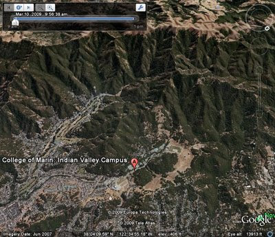
The Google Earth photo below shows this area. (Click on the photo to open a larger image in your Web browser).

Monday, March 26, 2018

SPRING 2018 HIKING SCHEDULE

Tuesday Meandering in Marin      Spring 2018
Time: 9:45 – 1:45
Instructor: Wendy Dreskin
WHAT TO BRING: Water, lunch, warm layer, hat, sunscreen. Optional equipment: hiking poles, binoculars, camera. Walks go rain or shine, so wear raingear when appropriate.

April 3 INDIAN VALLEY COLLEGE OPEN SPACE.
     Two loops combine to make an interesting hike. Tomcat Clover, Fiddleneck, and Plectritis should be in bloom this week, and if we haven't heard the first Pacific slope flycatcher yet, we often hear it at IVC.
     Take 101 to the Ignacio Blvd. exit. Go west and follow Ignacio Blvd. into the campus. Our hike starts from the athletic field near the police station. Bring quarters to get a ticket from the parking machines.
     25 minutes from College of Marin. Restrooms at trailhead.

April 10 CHIMNEY ROCK, POINT REYES NATIONAL SEASHORE
     This is one of Marin's must-see spring wildflower displays! We'll see elephant seals at the overlook and take time to learn about their history and return from the brink of extinction. We often see Pigeon Guillomots, Eared Grebes in breeding plumage, Common Loons, and Savannah Sparrows on this hike. Bring binoculars if you have them.
     Take Sir Francis Drake Blvd. At the junction with Pierce Point Rd, stay on Sir Francis Drake. Follow signs towards the Lighthouse and Drake’s Beach. You’ll pass the turn to Drake’s Beach on your left. Keep going until you see a left turn to Chimney Rock. (SFD continues on to end at the Lighthouse parking lot.)
     1 1/2 hours from College of Marin. Outhouse at trailhead.

April 17 MOUNT BURDELL OPEN SPACE
     We may see Cream Cups, Tidy Tips, Baby Stars, and Balloon Clover as well as seven or eight species of butterflies. This is the only spot where Bitterroot, the Montana state flower, grows in Marin. Lunch at Hidden Lake (which given the lack of rain I expect will be Hidden Puddle or non-existent).            
       Take 101 north and take the San Marin Drive exit. Go west on San Marin Drive. Turn right on San Andreas Drive. The entrance to the Open Space will be on your right. If you come to the dead end of San Andreas you've only gone about half a block too far.
       No lot but plenty of curbside parking. 30 minutes from College of Marin. No restrooms on this hike.

April 24 GREEN GULCH, GGNRA   NOTE CORRECTION: NOT DEER PARK TO PHOENIX

     Today we get to see the beautiful organic vegetable garden at the Zen Center’s Green Gulch Farms on our way up to the Coyote Ridge Trail. Lunch overlooking the ocean on our way back down to Muir Beach.
     Take the Stinson Beach/Hway 1 exit off Hway 101. Go through Tam Junction, and take Shoreline Highway and follow signs to Muir Beach. Restrooms at trailhead. Time: 55 minutes from COM.

May 1 WOLFE RIDGE. GGNRA
     Wildflowers and views! "First of spring" flowers for this hike usually include Cobweb Thistle and Bee Plant, and we sometimes see the amazing fairy moth hanging out by oceanspray.
       From 101 South, take the last exit before the Golden Gate Bridge. Turn right, go under the freeway, and get in the left turn lane to go through the one way tunnel with the 5 minute traffic light. Follow the road down past the Marine Mammal Center and park at the end of the road. (The beach will be on the other side of the road.) 40 minutes from COM.

May 8 KENT PUMP ROAD
     While I know we all like loops, I was so excited about osprey nests last spring when I took this hike that I decided to add it to our itinerary. Kent Lake is the largest of the MMWD reservoirs. The first Osprey nest was found at Kent Lake in 1967 when ospreys had been so decimated by DDT it was a big deal to see one. The first bald eagle nested there in 2008. In 2017 there were about eighteen active nests. We’ll hike as far as the first few nests.
       Take the Fairfax-Bolinas Road to the Alpine Dam. Parking is limited, so carpool if possible. Park when you see the dam ahead (first choice), or cross the dam and turn around so you can park on the other side and walk back across the dam.
     Time: 35 minutes from College of Marin. No restrooms at trailhead.

May 15 FINAL EXAM ROCK SPRING, MOUNT TAMALPAIS
We could see coral roots (a native orchid), meadow rue, and golden banners on this mostly shady loop hike.
Take the Mill Valley exit, East Blithedale. Turn left on Camino Alto (left turn only lane). Turn right on Miller Ave. Turn left on Montford. (The 2AM Club is the landmark.) Turn right on Molino. There is a yellow dividing line on the road you follow, so if in doubt "follow the yellow line road." Molino becomes Edgewood which become Sequoia Valley Road. At a big intersection turn right onto Panoramic Hway. At the intersection where the Pantoll Ranger Station is, turn right on Pantoll. (In other words, keep going uphill.) You'll come to an intersection with Ridgecrest Blvd. You'll be facing a dirt parking lot. This is Rock Spring. Park here
     Bring a plate and utensils, and food to share for the Gourmet Final!
     Driving time from College of Marin 55 minutes. Outhouse at trailhead and mid-way.

Sunday, March 25, 2018

A Marin IJ article - Wendy is being inducted into the Marin Hall of Fame


Marin Hall of Fame women to be honored in San Rafael ceremony


Marin Women’s Hall of Fame Class of 2018 includes, top left to right, Cyane Dandridge and Jane Kramer; bottom left to right, Trisha Garlock, Patricia Arrigoni and Wendy Dreskin. (Photos by Linda Russell; Arrigoni by Carol Visalli)
Marin Women’s Hall of Fame Class of 2018 includes, top left to right, Cyane Dandridge and Jane Kramer; bottom left to right, Trisha Garlock, Patricia Arrigoni and Wendy Dreskin. (Photos by Linda Russell; Arrigoni by Carol Visalli) 

While their work spans from environmentalism to conservation efforts to advocating for and working with children, these five women have one thing in common: they will be inducted into the Marin Women’s Hall of Fame this week.
The honorees are Cyane Dandridge, executive director of Strategic Energy Innovations; Wendy Dreskin, who spearheaded the Junior Botanist Program and Junior Bird Watcher program; Jane Kramer, the founder and executive director of Enriching Lives through Music; Trisha Garlock, co-founder of the Mill Valley schools foundation Kiddo, and Patricia Arrigoni, co-founder of the Marine Mammal Center.
The annual induction and celebration dinner is at 5 p.m. March 29 at the Peacock Gap Golf Club in San Rafael. 
Since 1987, more than 140 women have been named to the Marin Women’s Hall of Fame — a project of the YWCA San Francisco and Marin — for their work and accomplishments that shape the life, culture and landscape of the county.
As executive director of nonprofit Strategic Energy Innovations, Dandridge works to educate the public about climate change, support environmental stewardship projects and make affordable housing more energy-efficient. In 2011, she created the Marin School of Environmental Leadership to inspire and foster the next generation of environmental leaders.
For decades, Dreskin, a lifelong naturalist, has encouraged people of all ages to connect to and learn about the environment. The IJ hiking columnist spearheaded the Junior Botanist Program and Junior Bird Watcher program, which have reached thousands of Marin elementary school students, has led the College of Marin nature/hiking class Meandering in Marin since 1998 and teaches other classes to adults and children.
Kramer wants children to “compose their own lives.” She founded and is the executive director of Enriching Lives through Music, the full scholarship, multi-year, music program in the Canal neighborhood, which provides instruments, classes and performance opportunities to children.
Since Garlock co-founded Kiddo, the Mill Valley Schools Community Foundation, in 1982, the nonprofit has raised tens of millions of dollars for students to have access to art, music, drama, poetry, dance and physical education programs, as well as technology support, teacher grants, classroom and library aides. After serving as executive director of Kiddo for 32 years, she now is president of SchoolsRule-Marin.
Arrigoni is one of the founders of the Marine Mammal Center, a nonprofit veterinary research hospital and educational center, which since 1975 has rescued, rehabilitated and released marine mammals, as well as educated the public about environmentalism. She spends her time volunteering for various conservation organizations and spearheading local conservation efforts. She’s written multiple books including one about the center, “The Marine Mammal Center, How it all Began.”

Saturday, March 24, 2018

REMINDER - NO HIKE THIS TUESDAY MARCH 27, 2018

Just a quick reminder that there will be no hike this coming Tuesday, March 27, 2018.

The next scheduled Tuesday hike is April 3rd at Indian Valley College Open Space. That will be the first hike of Spring 2018.  


Saturday, March 17, 2018

REMINDER - NO HIKE THIS TUESDAY 3/20/2018

Just a quick reminder that there will be no hike this coming Tuesday, March 20, 2018.

The next scheduled Tuesday hike is April 3rd at Indian Valley College Open Space.

Also, there is no hike on Tuesday, March 27th.

Enjoy the rest of March.

Wednesday, March 14, 2018

Two Free Hikes with Wendy, 4/8/2018 and 4/22/2018

Wendy is offering two free hikes, April 8 and April 22, 2018.
Hike No. 1


Wendy is leading this hike through LandPaths on April 8.  Wendy says: "Don't worry that it says Walter is the leader - he is the docent with the key! The hike is free but you have to register. My former student Lucas Corneliussen will be on hand to catch butterflies and spot birds."  
         
Birds, Butterflies, Hosts & Late Bloomers
Bohemia Ecological Preserve Hike leader: Walter Drucker, Bohemia Ecological Preserve Docent

Join us for a special hike with seasoned naturalist Wendy Dreskin, who will share her vast knowledge and enthusiasm as we explore the birds, butterflies and their habitat on this beautiful 1000 acre preserve. We will stop for lunch during our meander.
Moderate hike with some hills, 3-4 miles.

Hike Details: From the Preserve entrance,we'll need a few people to volunteer the use of their vehicles to drive us up to Hut Hill where the hike will begin. Please come prepared for a hike over moderate terrain with some steep sections, about 3-4 miles. Clink on link for Bohemian Ecological Preserve


When and Where: We will meet at 10am at the Bohemia Ecological Preserve, 6773 Bohemian Highway,j ust past Westminster Woods. From the intersection of Graton Road and Bohemian Highway in Occidental, travel approximately 3 miles north on Bohemian Highway. The Preserve is on the right-hand side (if you are coming from Occidental) & looks like a quarry. Watch for staff or volunteers located at Bohemian Highway to direct you to parking!  


  • You will be asked to sign a liability waiver.
  • There is one porta-potty on the property (2/3 mile into our hike). There is no potable water available on the property.
  • No pets or smoking are permitted and absolutely no smoking pets!

Directions: Take 101 to the Ignacio Blvd. exit. Go west and follow Ignacio Blvd. into the campus. Our hike starts from the athletic field near the police station. Bring money to get a ticket from the parking machines.

Note on Timing: We will do our best to get back to our vehicles by 2:00 pm. However, it is possible we will get back later than intended.  If you have plans directly after this hike that you cannot miss this may not be the outing for you.  Early departures cannot be accommodated.  Thank you for your understanding!

What to bring: Please bring or wear: sturdy boots or shoes, a hat, weather appropriate clothing in layers, picnic lunch/ snacks & water, binoculars, cameras, hiking poles, and sunscreen.  

Details, Details:
We will stay together as a group & leave together.  Early departures cannot be accommodated except in case of medical emergency.

Hike No. 2

Free Earth Day hike with Marin Audubon.


Location:Novato

Trip Leader(s): Lucas Corneliussen and Wendy Dreskin

Date: Sunday, April 22  Earth Day

Start Time: 9 AM

End Time: 12:30 PM

Description: IVC Open Space Once part of the Pacheco family dairy ranch, this 653 acre open space was acquired in 1975.  It is mostly oak/bay/madrone woodland with two creeks and a man-made pond. 
We will be looking and listening for spring migrants like Pacific Slope Flycatchers, Warbling Vireos, and Orange-Crowned Warblers as well as the spring songs of resident birds.  Wear sturdy hiking shoes and be prepared to hike for several miles. Young birders especially welcome. Bring water, lunch, sunscreen, hat and dress in layers.  NOTE: This will be a shorter hike than what we'll do in the spring session of meandering. 

Restrooms at trailhead.  

Friday, March 9, 2018

Bon Tempe Lake - 3/13/18


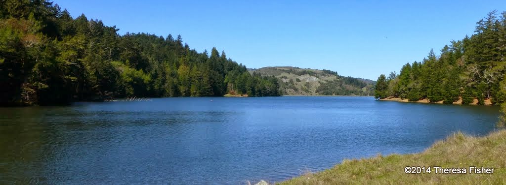
This is a lovely, level lakeside loop! We could see Ring-necked Ducks, Common Mergansers, American Widgeons, Ruddy Ducks, Buffleheads, and more. This could also be the week for our first Acmon Blue butterfly!

(Click here for a recap of our 2010 hike. There's also an album of photos taken on past hikes.)

Remember to bring your contribution to our gourmet feast, a plate, cup, and utensils. If it rains, Wendy opens her home so we may have our potluck inside. Her address is 10 East Ct. San Anselmo. 

Directions to her house follow: from Sir Francis Drake eastbound, as you would be if coming from Lake Lagunitas: left on Suffield which becomes Valley if you go straight when Suffield veers right.  Right on Traxler. Right (but not the hard right) on Hillcrest. Left on East Ct.  Don't worry about blocking in other cars as we'll all leave about the same time. 

If you skip the hike and want to come for the potluck here are directions from Sir Francis Drake Blvd westbound: Right on Butterfield. (There is a right turn only lane.) At the first stop sign, left on Rutherford. Hard right on Camino de Herrera. Right on Hillcrest Ct. Left on East Ct.  Don't worry about blocking in other cars as we'll all leave about the same time. 

Directions to trailhead: Take Sir Francis Drake Boulevard into Fairfax. Jog left and make an immediate right in front of the movie theater.

The first left puts you on Bolinas Avenue. Follow this until you see the sign on your left for Lake Bon Tempe and Lake Lagunitas.

Click here for the MMWD map and directions. Or click here for a Google Maps map showing the trailhead location; click on the teardrop icon to get driving directions and estimated travel time from your location.

Unless you have an MMWD pass, continue past the old toll booth, pull over at the parking area on the right and pay the day use fee, and then continue driving until you reach the end of the road.

The day use fee is $8.  You can use a credit card, $1, $5, or $10 bills (but not coins or $20 bills) at the automated pay station.

Annual watershed area parking passes for Marin residents are $60 ($30 for those 62 and older). You can buy them online or at the MMWD main office in Corte Madera.

Time: 30 minutes from College of Marin. Outhouse in parking lot; portables en route

Carpoolers can meet at St. Rita's Church at 9:20 a.m. Click here for a Google Maps map showing St. Rita's ("A") and directions and estimated driving time to the trailhead.

We’ll have lunch at the picnic area at Lake Lagunitas so you don’t need to carry the food for the potluck.

Weather forecast:  As of Friday, March 9th, the National Weather Service forecast for the hike was showers likely. Mostly cloudy with a high near 58. (Click here for an updated forecast).

More on this hike: Hike "C13 Bon Tempe Lake Trail" in the Martins' book, Hiking Marin, shows the general area where we will be hiking. However, we'll start and end at trail junction #2 on their map, rather than at Bon Tempe dam. (Click here for an MMWD map that shows this area).


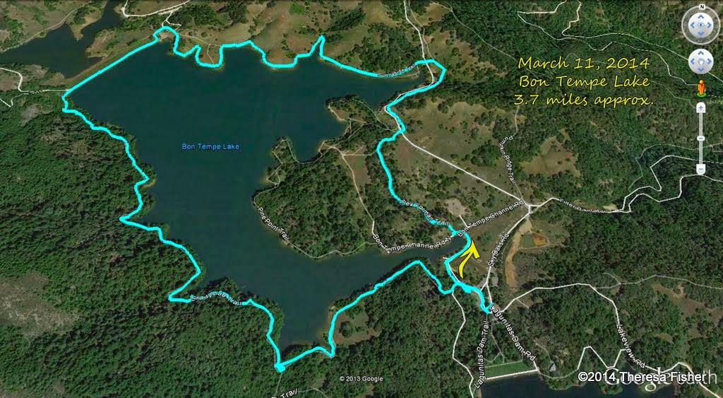
This hike is a little shorter than average at about 3.7 miles, without a great deal of elevation change.


The Google Earth image below shows both lakes in a view looking back towards Fairfax. (Click on the photo to open a larger image in your Web browser).


Friday, March 2, 2018

REMINDER-SPRING REGISTRATION BEGINS MONDAY 3/5/18


Spring 2018 is coming!

The Spring 2018 Quarter schedule will be mailed starting Tuesday February 27, 2018.

Registration for the College of Marin Community Education courses, including the Meandering in Marin Spring series, starts on Monday, March 5, 2018 at 9:00 a.m.

Here is the information you'll need to sign up:

EC | Meandering in Marin: Natural History and Hiking
If you enjoy getting exercise, socializing with a congenial group, and learning about birds, flowers, butterflies, and mushrooms, come join the Meanderers. The instructor will send field trip itineraries to enrolled students before the first class.

3251| Dreskin | OFF | TBA
7 Mondays 9:45am–1:45pm | Apr 2-May 14
3252 | Dreskin | OFF | TBA
7 Tuesdays 9:45am–1:45pm | Apr 3- May 15
$155 | ESCOM $131 per course

Thursday, March 1, 2018

Deer Park to Lake Phoenix (3/6/2018)

This is a scenic hike with lunch at Phoenix Lake.  We should see Red Larkspur, Gypsum Spring Beauty, Baby Blue Eyes, and Ground Iris  Maybe we'll hear the first Orange-Crowned Warblers of the season singing their spring song!  (Click here for a recap of our hike in March 2010 or here for photos from past hikes.)

Directions to trailhead:  Go west on Sir Francis Drake Boulevard to Fairfax. As you enter Fairfax, turn left at the gas station, and make an immediate right in front of the movie theater. This puts you on Broadway.

Make the first left onto Bolinas Avenue. Just after it veers left, turn left on Porteous Avenue. Follow it to the parking lot at Deer Park.

(Click here for a Google Maps map showing the location of Deer Park. Click on the teardrop icon to get driving directions and estimated driving time from your location.)

15 minutes from College of Marin. Carpoolers can meet at St. Rita's Church at 9:30 a.m.

Restrooms at trailhead.

Weather forecast:  As of Thursday, March 1st, the National Weather Service forecast for the hike was partly sunny, with a high near 60. (Click here for an updated forecast).

More on this hike: Presumably we'll follow the same route as in the past. The Martin's Hiking in Marin trail guide does not have a single map and directions for our hike from Deer Park School to Phoenix Lake and back, but you can use the following two maps and hikes from their book to piece together our path:

Start off using the Martin's Hike "C6 - Deer Park Road - Yolanda Trail." Head up the Deer Park Fire Road to Oak Tree Junction, then turn left (to the south) and hike uphill on the Six Points Trail. When you reach the Six Points junction, switch to Hike "C4 - Hidden Meadow - Yolanda Trail" and hike down the Yolanda South Trail to Phoenix Lake.

Using that same hike and map, follow Shaver Grade uphill, and while doing so, refer back to the C6 hike and map to follow the Grade to Five Corners. Continue straight down Deer Park Fire Road to Boy Scout Junction. Cross the fire road and take the Junction Trail back to its intersection with Deer Park Fire Road (just where you turned off onto Six Points Trail when you were headed toward the lake).

Here's a Google Earth view looking from Deer Park over Bald Hill towards Phoenix Lake.

Here's the hike's profile.